
Demographic features of the population of Botswana include population density, ethnicity, education level, health of the populace, economic status, religious affiliations and other aspects.

Gaborone is the capital and largest city of Botswana with a population of 246,325 based on the 2022 census, about 10% of the total population of Botswana. Its agglomeration is home to 421,907 inhabitants at the 2011 census. Gaborone has per capita income of US$32,000 (PPP), the highest in Africa.

Kgalagadi is a district in southwest Botswana, lying along the country's border with Namibia and South Africa. The administrative center is Tsabong. The district of Kgalagadi covers a large part of the Kalahari Desert. It has a total area of 105,200 km2 and has a population of 42,000 (2001). More than one-third of the district is covered by the Kgalagadi Transfrontier Park, which extends into South Africa, and which is a major tourist attraction.
Lobatse is a town in south-eastern Botswana, 70 kilometres south of the capital Gaborone, situated in a valley running north towards Gaborone and close to the border with South Africa. Lobatse has a population of 29,772 as of 2022. The town is an administrative district, with a town council.

Southern is one of the districts of Botswana. The capital of Southern district is Kanye, home to the Bangwaketse and Barolong in Botswana. The Southern district is home to Botswana's second largest beef farmers where there are large privately owned ranges, and several government run beef ranges which provide agricultural support to the local farmers. Maize and sorghum, Botswana's staple crop, are also raised in the area. Southern district is where the third diamond mine of Botswana was found, which buoys Botswana's economic state of prosperity. It was the first district to house the capital city before being moved to Gaborone after independence.

The North-East District is one of the administrative districts of Botswana. Its capital is Francistown. In 2011, North-East had a population of 60,264 people. The district is predominantly occupied by Kalanga-speaking people, the BaKalanga. The district is administered by a district administration and district council, which are responsible for local administration.

The North-West District or Ngamiland is one of the first-level administrative subdivisions of Botswana. For census and administrative purposes Ngamiland is subdivided into Ngamiland East, Ngamiland West and Ngamiland Delta (Okavango). It is governed by a District Commissioner, appointed by the national government, and the elected North-West District Council. The administrative centre is Maun.
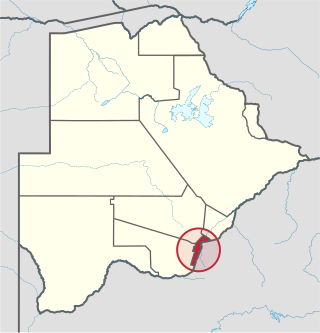
South-East is one of the districts of Botswana. The capital city of Botswana, Gaborone, is surrounded by this district. The administrative capital for the South-East district is the village of Ramotswa. In the southeast, South-East borders the North West Province of South Africa. Domestically, it borders Kgatleng in northeast, Kweneng in northwest, Southern in southwest.

Gumare or Gomare is a rural village located in the North-West District of Botswana, near the Okavango Delta. The population of Gumare was 6,067 in 2001 census, but had risen to 8,532 iby the 2011 census.

Kasane is a town in Botswana, close to Africa's 'Four Corners', where the borders of Botswana, Namibia, Zambia and Zimbabwe almost meet. The town is at the far northeastern corner of Botswana where it serves as the administrative center of the Chobe District. The population of Kasane was 9,244 at the 2011 census.

Kanye is a village in southern Botswana, located 83 kilometres (52 mi) south-west of the capital, Gaborone. It is the administrative centre of the Southern District, and had a population of 48,028 as of the 2022 Population and Housing Census. This is an increase compared to the 45,196 of the 2011 census, making it the ninth-largest village in the country. Kanye is the traditional capital of the Ngwaketse tribe, who first settled in the area in the 1790s. The village is the longest continuously-occupied tribal capital in the country.
Mogoditshane is a town located in the Kweneng District of Botswana.

Tsabong, also spelled Tshabong, is the administrative centre of the Kgalagadi District in Botswana. It is located in the Kalahari Desert. The population was 8939 in the 2011 census.

Hinduism is a minority religion practised by 0.3% of the population of Botswana. The practice of Hinduism in Botswana is concentrated in and around Gaborone and Selebi-Phikwe. The community of Hindus began to form in the early 20th century with the beginning of immigration from India to Botswana. Most Hindus in Botswana are of Indian descent.
Botswana is experiencing one of the most severe HIV/AIDS epidemics in the world. The national HIV prevalence rate among adults ages 15 to 49 is 24.8 percent, which is the third highest in the world, behind Lesotho and Eswatini. HIV/AIDS threatens the many developmental gains Botswana has achieved since its independence in 1966, including economic growth, political stability, a rise in life expectancy, and the establishment of functioning public educational and health care systems.
Gabane is a village in Kweneng District of Botswana. It is located 15 km (10 mi) west of Gaborone, the capital of Botswana. The population was 10,399 in 2001 census, making it the fourth largest settlement in Kweneng. Its population was 14,842 at the 2011 census. It's now part of Gaborone agglomeration home to 421,907 inhabitants at the 2011 census.
Otse is a village in the South-East District of Botswana. It is located 60 km south of Gaborone, along the Gaborone–Lobatse road and close to the border with South Africa. This village is home to the Balete people who are related to those in Ramotswa, Gabane and Mogobane. The population was 7,636 in 2011 census.
Mmopane is a village in the Kweneng District of Botswana. The village is located around 15 km from Gaborone, the capital of Botswana. The population was 3,512 in 2001 census and 14,655 at the 2011 census. It's now part of Gaborone agglomeration home to 421,907 inhabitants at the 2011 census.
Kopong is a small village in Kweneng District of Botswana. It is located around 25 km north of Gaborone, the capital of Botswana. The population was 5,571 in 2001 census and 9,520 at the 2011 census, making it the sixth largest settlement in Kweneng. It is now becoming a suburb of Gaborone agglomeration home to 421,907 inhabitants at the 2011 census.

Christianity is the largest religion in Botswana. However, the country is officially secular and allows freedom of religious practice.
