Mmutlane

Last updated
Mmutlane
Village
Botswana location map.svg
Red pog.svg
Mmutlane
Location in Botswana
Coordinates: 23°02′46″S26°34′37″E / 23.046°S 26.577°E / -23.046; 26.577 Coordinates: 23°02′46″S26°34′37″E / 23.046°S 26.577°E / -23.046; 26.577
Country Botswana
District Central District
Population (2001)
  Total 841

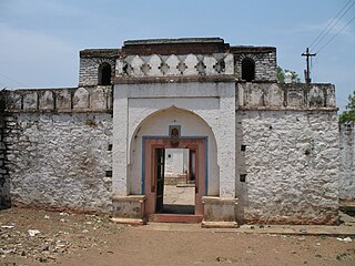
Mmutlane, also known as Mmutlana, is a village in the Central District of Botswana. It is located 30 km north-west of Mahalapye, close to the village of Shoshong. Mmutlane has a primary school, and the population was 841 in the 2001 census. [1]

Central District (Botswana) District in Botswana

Central is the largest of Botswana's districts in terms of area and population. It encompasses the traditional homeland of the Bamangwato people. Some of the most politically connected Batswana have come from the Central District, including former President Sir Seretse Khama, former President Festus Mogae, and current President Lt. General Seretse Ian Khama. The district borders the Botswanan districts of Chobe in the north, North-West in the northwest, Ghanzi in the west, Kweneng in southwest, Kgatleng in the south and North-East in the northeast, as well as Zimbabwe also in the northeast and South Africa in the southeast.

Botswana republic in southern Africa

Botswana, officially the Republic of Botswana, is a landlocked country in Southern Africa. Formerly the British protectorate of Bechuanaland, Botswana adopted its new name after becoming independent within the Commonwealth on 30 September 1966. Since then, it has been a representative republic, with a consistent record of uninterrupted democratic elections and the best perceived corruption ranking in Africa since at least 1998. It is currently Africa's oldest continuous democracy.

Mahalapye Place in Central District, Botswana

Mahalapye is a town located in the Central District of Botswana. The town has about 41,000 inhabitants and is situated along the main road between the capital Gaborone and the second largest city Francistown. Mahalapye has a bus station, a railway station, a couple of hotels and a market area with many shops and fast food restaurants, Water Shed mall is the latest attraction to those travelling from Gaborone to Francistown, great place for refreshments. It also has several petrol stations, some open 24 hours per day. Being situated on the edge of the Kalahari desert it is quite dry, and the local waterways are dry except during the rainy season. In recent times, it has become a convenient stop-over town for travelers travelling to and from Gaborone.

Related Research Articles

Peerkankaranai neighbourhood in Chennai, Tamil Nadu, India

Peerkankaranai is a town in Southern part of the metropolitan city of Chennai in the Indian state of Tamil Nadu.

The 1991 Nepal census was a widespread national census conducted by the Nepal Central Bureau of Statistics.

Belagali village in Karnataka, India

Belagali is a panchayat village in the southern state of Karnataka, India. It is located in the Mudhol taluka of Bagalkot district in Karnataka, about 4 km east of the town of Mahalingpur.

Dhupadal village in Karnataka, India

Dhupadal is a village in the southern state of Karnataka, India. It is located in the Gokak taluk of Belgaum district in Karnataka.

Halaga village in Karnataka, India

Halaga is a village in the southern state of Karnataka, India. It is located in the Belgaum taluk of Belgaum district in Karnataka.

Mouje Nandgad village in Karnataka, India

Mouje Nandgad is a village in the southern state of Karnataka, India. It is located in the Khanapur taluk of Belgaum district in Karnataka.

Muchandi village in Karnataka, India

Muchandi is a village in the southern state of Karnataka, India. It is located in the Belgaum taluk of Belgaum district in Karnataka.

Nipanal village in Karnataka, India

Nipanal is a village in the southern state of Karnataka, India. It is located in the Raybag taluk of Belgaum district in Karnataka.

Pachapur village in Karnataka, India

Pachapur is a village in the southern state of Karnataka, India. It is located in the Hukeri taluk of Belgaum district in Karnataka.

Paramanandwadi village in Karnataka, India

Paramanandwadi is a village in the southern state of Karnataka, India. It is located in the Raybag taluk of Belgaum district in Karnataka.

Sulebhavi village in Karnataka, India

Sulebhavi is a village in the southern state of Karnataka, India. It is located in the Belgaum taluk of Belgaum district in Karnataka.

Uchagaon village in Karnataka, India

Uchagaon is a village in the southern state of Karnataka, India. It is located in the Belgaum taluk of Belgaum district in Karnataka. Last village on the way towards maharastra.

Yadwad Village in Karnataka, India

Yadwad is a village in the southern state of Karnataka, India. It is located in the Gokak taluk of Belgaum district in Karnataka.

Yalimunoli village in Karnataka, India

Yalimunoli is a village in the southern state of Karnataka, India. It is located in the Hukeri taluk of Belgaum district in Karnataka.

Yemakanmardi village in Karnataka, India

Yamakanmardi is a village in the southern state of Karnataka, India. It is located in the Hukeri taluk of Belgaum district in Karnataka.

Karajagi Village in Karnataka, India

Karajagi is a village in jath, in the state of Maharashtra]], India. It is located in the [jath]] taluk of sangli district.

Ingalagi is a panchayat village in Belgaum district in the southern state of Karnataka, India.

Hanchinala village in Karnataka, India

Hanchinala is a village in the Saundatti taluka of Belgaum district in Karnataka. In 2001, it had a population of 6232 with 3189 males and 3043 females.

Nepal conducted a widespread national census in 2011 by the Nepal Central Bureau of Statistics. Working with the 58 municipalities and the 3915 Village Development Committees at a district level, they recorded data from all the municipalities and villages of each district. The data included statistics on population size, households, sex and age distribution, place of birth, residence characteristics, literacy, marital status, religion, language spoken, caste/ethnic group, economically active population, education, number of children, employment status, and occupation.

References