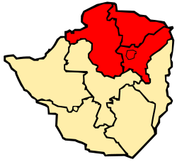
Mashonaland

Last updated
Map of Zimbabwe showing Mashonaland Mashonaland.svg
Map of Zimbabwe showing Mashonaland
PersonMuShona [1]
People Mashona
Language chiShona
CountryMashonaland

Mashonaland is a region in northern Zimbabwe. It is home to nearly half of the population of Zimbabwe. The majority of the Mashonaland people are from the Shona tribe while the Zezuru and Korekore dialects are most common. Harare is the largest city followed by Chitungwiza.

Contents

Currently, Mashonaland is divided into four provinces,

The Zimbabwean capital of Harare, a province unto itself, lies entirely in Mashonaland.

Provincial history

It was originally one of the regions that the country was divided into following occupation by the Pioneer Column in 1890 and designated the extent of territory under administration of the British South Africa Company as distinct from the remainder of the territory that was directly under the control of the Matabele king, Lobengula, which was named Matabeleland when it was occupied in 1893. The two had separate administrations for part of the BSA Company colonial period.

Revolt broke out against the British South Africa Company in 1896, led by priests of the Mwari religion. The British prevailed, executed some leaders, and tried to reform the system. [2]

In 1923, the territory became part of the self-governing colony of Southern Rhodesia and Mashonaland became one of the five provinces. In 1970, an administrative reform led to Mashonaland being divided into a northern and a southern half. Most recently, in 1983, it was divided into the current three sectors and the capital city of Harare was given its own provincial status as well. Since the constitutional amendments that took effect in 1988, each is run by a governor appointed by the president. [3]

Demographics

Around 7.4 million people live in Mashonaland, around 50% of the population of Zimbabwe. Population growth was higher than in southern Zimbabwe. [4]

ProvincePopulation
(2022 census)
Mashonaland West 1,893,584
Mashonaland Central 1,384,891
Mashonaland East 1,731,173
Harare 2,427,231
Total7,436,879

Geographical features

The territory is composed of a broad plateau that slopes gradually to the north and north-west. The lowest land is on its northern border, which is formed by the Zambezi River, with Zambia beyond. A small part straddles the plateau at its south-eastern edge and here the land drains into the Save River but the rest of Mashonaland is part of the Zambezi drainage basin. To the south, the Munyati River forms the border with the current and former province of Midlands. The Nyangadzi river forms the border with Manicaland to the east.

Much of the landform is rolling low hills divided by river valleys. About half the land is over 1,200 metres (3,900 ft) altitude and the central watershed in the south and centre is at 1,500–1,650 metres (4,920–5,410 ft). Only a few isolated mountains and the spine of the Umvukwes Range in the west rise higher. The highest point is in the Wedza Mountains in the south east at 1,789 metres (5,869 ft).

Economy

The region's economy consists of the mining, agriculture and the service industry. Its facilities for tourism, fertile lands and mineral filled regions such as Bindura could improve the economy,[ original research? ] but due to poor leadership and policies, the economy is lagging behind.[ original research? ] Many Mashonaland citizens are farmers, and gain their source of income from agriculture.

Related Research Articles

<span class="mw-page-title-main">Geography of Zimbabwe</span> Geographical features of Zimbabwe

Zimbabwe is a landlocked country in southern Africa lying north of the Tropic of Capricorn. During summer, the whole country experiences warm temperatures as a result of the sun being directly overhead. It straddles an extensive high inland plateau that drops northwards to the Zambezi valley where the border with Zambia is and similarly drops southwards to the Limpopo valley and the border with South Africa.

<span class="mw-page-title-main">Zambia</span> Country at the crossroads of Central and Southern Africa

Zambia, officially the Republic of Zambia, is a landlocked country at the crossroads of Central, Southern and East Africa. It is typically referred to being in South-Central Africa or Southern Africa. It is bordered to the north by Democratic Republic of the Congo, Tanzania to the north-east, Malawi to the east, Mozambique to the southeast, Zimbabwe and Botswana to the south, Namibia to the southwest, and Angola to the west. The capital city of Zambia is Lusaka, located in the south-central part of Zambia. The population is concentrated mainly around Lusaka in the south and the Copperbelt Province to the north, the core economic hubs of the country.

<span class="mw-page-title-main">Geography of Zambia</span>

Zambia is a landlocked country located in Southern Africa, to the east of Angola. It has a total area of 752,618 square kilometres, of which 9 220 km2 is water.

<span class="mw-page-title-main">Victoria Falls</span> Waterfall on the Zambezi River in Zambia and Zimbabwe

Victoria Falls is a waterfall on the Zambezi River in southern Africa, which provides habitat for several unique species of plants and animals. It is located on the border between Zambia and Zimbabwe and is one of the world's largest waterfalls, with a width of 1,708 m (5,604 ft).

<span class="mw-page-title-main">Southern Rhodesia</span> British colony in Africa, 1923 to 1965

Southern Rhodesia was a landlocked self-governing British Crown colony in southern Africa, established in 1923 and consisting of British South Africa Company (BSAC) territories lying south of the Zambezi River. The region was informally known as south Zambesia until annexed by Britain at the behest of Cecil Rhodes's British South Africa Company, for whom the colony was named. The bounding territories were Bechuanaland (Botswana), Northern Rhodesia (Zambia), Portuguese Mozambique (Mozambique), and the Transvaal Republic.

<span class="mw-page-title-main">Manicaland Province</span> Province in Zimbabwe

Manicaland is a province in eastern Zimbabwe. After Harare Province, it is the country's second-most populous province, with a population of 2.037 million, as of the 2022 census. After Harare and Bulawayo provinces, Manicaland is Zimbabwe's third-most densely populated province. Manicaland was one of five original provinces established in Southern Rhodesia in the early colonial period. The province endowed with country's major tourist attractions, the likes of Mutarazi Falls, Nyanga National Park and Zimbabwe's top three highest peaks. The province is divided into ten administrative subdivisions of seven rural districts and three towns/councils, including the provincial capital, Mutare. The name Manicaland is derived from one of the province's largest ethnic groups, the Manyika, who originate from the area north of the Manicaland province and as well as western Mozambique, who speak a distinct language called ChiManyika in Shona.

<span class="mw-page-title-main">Matabeleland North Province</span> Province in Zimbabwe

Matabeleland North is a province in western Zimbabwe. With a population of 827,645 as of the 2022 census, it is the country's second-least populous province, after Matabeleland South, and is the country's least densely populated province. Matabeleland North and Matabeleland South were established in 1974, when the original Matabeleland Province was bifurcated. In 1997, the province lost territory when the city of Bulawayo became a province in its own right. Matabeleland North is divided into seven districts. Its capital is Lupane, and Victoria Falls and Hwange its largest towns. The name "Matabeleland" is derived from the Matabele or Ndebele people, the province's largest ethnic group.

<span class="mw-page-title-main">Provinces of Zimbabwe</span> Constituent political entities of Zimbabwe

Provinces are constituent political entities of Zimbabwe. Zimbabwe currently has ten provinces, two of which are cities with provincial status. Zimbabwe is a unitary state, and its provinces exercise only the powers that the central government chooses to delegate. Provinces are divided into districts, which are divided into wards.

<span class="mw-page-title-main">Matabeleland</span> Region of southwestern Zimbabwe

Matabeleland is a region located in southwestern Zimbabwe that is divided into three provinces: Matabeleland North, Bulawayo, and Matabeleland South. These provinces are in the west and south-west of Zimbabwe, between the Limpopo and Zambezi rivers and are further separated from Midlands by the Shangani River in central Zimbabwe. The region is named after its inhabitants, the Ndebele people who were called "Amatabele"(people with long spears – Mzilikazi 's group of people who were escaping the Mfecani wars). Other ethnic groups who inhabit parts of Matabeleland include the Tonga, Bakalanga, Venda, Nambya, Khoisan, Xhosa, Sotho, Tswana, and Tsonga.

<span class="mw-page-title-main">British South Africa Company</span> 1889–1965 British mining and colonial enterprises company

The British South Africa Company was chartered in 1889 following the amalgamation of Cecil Rhodes' Central Search Association and the London-based Exploring Company Ltd, which had originally competed to capitalize on the expected mineral wealth of Mashonaland but united because of common economic interests and to secure British government backing. The company received a Royal Charter modelled on that of the British East India Company. Its first directors included The 2nd Duke of Abercorn, Rhodes himself, and the South African financier Alfred Beit. Rhodes hoped BSAC would promote colonisation and economic exploitation across much of south-central Africa, as part of the "Scramble for Africa". However, his main focus was south of the Zambezi, in Mashonaland and the coastal areas to its east, from which he believed the Portuguese could be removed by payment or force, and in the Transvaal, which he hoped would return to British control.

<span class="mw-page-title-main">Rhodesia (region)</span> Historical region in southern Africa

Rhodesia, known initially as Zambesia, is a historical region in southern Africa whose formal boundaries evolved between the 1890s and 1980. Demarcated and named by the British South Africa Company (BSAC), which governed it until the 1920s, it thereafter saw administration by various authorities. It was bisected by a natural border, the Zambezi. The territory to the north of the Zambezi was officially designated Northern Rhodesia by the company, and has been Zambia since 1964; that to the south, which the company dubbed Southern Rhodesia, became Zimbabwe in 1980. Northern and Southern Rhodesia were sometimes informally called "the Rhodesias".

<span class="mw-page-title-main">Zimbabwe Bird</span> National emblem of Zimbabwe

The stone-carved Zimbabwe Bird is the national emblem of Zimbabwe, appearing on the national flags and coats of arms of both Zimbabwe and former Rhodesia, as well as on banknotes and coins. It probably represents the bateleur eagle or the African fish eagle. The bird's design is derived from a number of soapstone sculptures found in the ruins of the medieval city of Great Zimbabwe.

<span class="mw-page-title-main">Pioneer Column</span> Military force of the British South Africa Company

The Pioneer Column was a force raised by Cecil Rhodes and his British South Africa Company in 1890 and used in his efforts to annex the territory of Mashonaland, later part of Zimbabwe.

<span class="mw-page-title-main">Munyati River</span> River in Zimbabwe

The Munyati River is a river in Zimbabwe. Under the Rhodesian administration, it was officially named the Umniati, but its spelling was changed in 1983 to more closely resemble the correct Shona pronunciation.

Articles related to Zimbabwe include:

<span class="mw-page-title-main">Outline of Zimbabwe</span> Overview of and topical guide to Zimbabwe

The following outline is provided as an overview of and topical guide to Zimbabwe:

<span class="mw-page-title-main">Languages of Zimbabwe</span> Languages of Zimbabwe

Many languages are spoken, or historically have been spoken, in Zimbabwe. Since the adoption of its 2013 Constitution, Zimbabwe has 16 official languages, namely Chewa, Chibarwe, English, Kalanga, Koisan, Nambya, Ndau, Ndebele, Shangani, Shona, sign language, Sotho, Tonga, Tswana, Venda, Xhosa. The country's main languages are Shona, spoken by only 42% of the population, and Ndebele, spoken by roughly 39%. English is the country's lingua franca, used in government and business and as the main medium of instruction in schools. English is the first language of most white Zimbabweans, and is the second language of a majority of black Zimbabweans. Historically, a minority of white Zimbabweans spoke Afrikaans, Greek, Italian, Polish, and Portuguese, among other languages, while Gujarati and Hindi could be found amongst the country's Indian population. Deaf Zimbabweans commonly use one of several varieties of Zimbabwean Sign Language, with some using American Sign Language. Zimbabwean language data is based on estimates, as Zimbabwe has never conducted a census that enumerated people by language.

Glen View is a high-density suburb that lies on the border of Harare Province and Mashonaland West. It split between the two provinces, with the larger part on Harare’s side and the remainder on Mashonaland West side under their governance of Zvimba Rural District. It is believed to have 160,000(6.4% of Harare’s population) people although the Zimstat says it has on 45,000 people. It shares boundaries with Budiriro on the North (4.341km), Glen Norah on the East(4.0km), South and West being Mashonaland West. It is divided into 8 parts namely Glen View 1, 2, 3, 4, 7, 8, 1 Extension and Riverside. It has around 15000 residential stands which ranges from 200sqm to 500sqm with most of them averaging 10 people per house.

References

  1. Haberland, Eike (May 3, 1974). Perspectives Des Études Africaines Contemporaines: Rapport Final D'un Symposium International. Deutsche UNESCO-Kommission. ISBN   9783794052257 via Google Books.
  2. Ranger 1967.
  3. Bridger 1973.
  4. "Zimbabwe: Administrative Division (Provinces and Districts) - Population Statistics, Charts and Map". www.citypopulation.de. Retrieved 2024-02-17.

17°36′S30°36′E / 17.600°S 30.600°E / -17.600; 30.600