The Limpopo River rises in South Africa and flows generally eastward through Mozambique to the Indian Ocean. The term Limpopo is derived from Rivombo (Livombo/Lebombo), a group of Tsonga settlers led by Hosi Rivombo who settled in the mountainous vicinity and named the area after their leader. The river is approximately 1,750 kilometres (1,087 mi) long, with a drainage basin 415,000 square kilometres (160,200 sq mi) in size. The mean discharge measured over a year is 170 m3 per second at its mouth. The Limpopo is the second largest river in Africa that drains to the Indian Ocean, after the Zambezi River.

The Zambezi River is the fourth-longest river in Africa, the longest east-flowing river in Africa and the largest flowing into the Indian Ocean from Africa. Its drainage basin covers 1,390,000 km2 (540,000 sq mi), slightly less than half of the Nile's. The 2,574-kilometre-long (1,599 mi) river rises in Zambia and flows through eastern Angola, along the north-eastern border of Namibia and the northern border of Botswana, then along the border between Zambia and Zimbabwe to Mozambique, where it crosses the country to empty into the Indian Ocean.
Palapye is a growing town in Botswana, situated about halfway between Francistown and Gaborone. Over the years its position has made it a convenient stopover on one of Southern Africa's principal north–south rail and road routes.

The Olifants River,Lepelle, iBhalule or Obalule is a river in South Africa and Mozambique, a tributary of the Limpopo River. It falls into the Drainage Area B of the Drainage basins of South Africa. The historical area of the Pedi people, Sekhukhuneland, is located between the Olifants River and one of its largest tributaries, the Steelpoort River.

Central is the largest of Botswana's districts in terms of area and population. It encompasses the traditional homeland of the Bamangwato people. Some of the most politically connected Batswana have come from the Central District, including former President Sir Seretse Khama, former President Festus Mogae, and former President Lt. General Seretse Ian Khama. The district borders the Botswanan districts of Chobe in the north, North-West in the northwest, Ghanzi in the west, Kweneng in southwest, Kgatleng in the south and North-East in the northeast, as well as Zimbabwe also in the northeast and South Africa in the southeast.

The Mokolo River is a major watercourse in Limpopo Province of South Africa. This river collects much of the drainage of the Waterberg Massif and discharges it to the Limpopo River. The river's catchment area comprises 8,387 square kilometres (3,238 sq mi).

The Shashe River is a major left-bank tributary of the Limpopo River in Zimbabwe. It rises northwest of Francistown, Botswana and flows into the Limpopo River where Botswana, Zimbabwe and South Africa meet. The confluence is at the site of the Greater Mapungubwe Transfrontier Conservation Area.
Maunatlala is a village in Central District of Botswana at the feet of the Tswapong Hills, near the Lotsane River. It is located 65 km (40 mi) east of Palapye and 60 km (37 mi) from the border with South Africa. The population was 4,364 in 2011 census. The village is the site of the Lotsane Dam, which started impounding in January 2012 and supplies drinking water as well as water for irrigation in a 250 hectares horticulture operation near Maunatlala.

The Tuli Block is a narrow fringe of land at Botswana's eastern border wedged between Zimbabwe in the north and east and South Africa in the south. It consists mainly of privately owned game farms offering safari tourism. The eastern section up to and including Redshield has been declared a game reserve, known as the Northern Tuli Game Reserve.

The Levubu River or Levuvhu is located in the northern Limpopo province of South Africa. Some of its tributaries, such as the Mutshindudi River and Mutale River rise in the Soutpansberg Mountains.

The Marico River or Madikwe is a river in Southern Africa. There are a number of dams in its basin. Groot Marico town is named after the Marico River. After it is joined on its right bank by the Crocodile River it is known as the Limpopo River.

The Mogalakwena River is one of the main watercourses in Limpopo Province, South Africa. It is also a major tributary of the Limpopo River.
The Nyl River is a watercourse in Limpopo Province, South Africa. It flows at the head of the Mogalakwena River, being its southernmost tributary or uppermost section. It is located near Mookgophong (Naboomspruit) in the northern part of the Springbok Flats, a particular geological formation.
The Nwanedi River is a watercourse in Limpopo Province, South Africa. It is a tributary of the Limpopo River flowing east of the Nzhelele, joining the right bank of the Limpopo 58 km east of Musina at the South Africa/Zimbabwe border.

The Notwane River is a river in southeastern Botswana. Certain sections of its course form the international boundary with South Africa. Its mouth is at the head of the Limpopo River. It has a catchment area of 18,053 square kilometers.

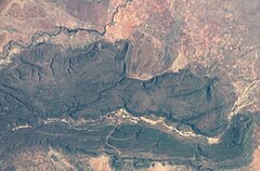
The Tswapong Hills are a mountain range in the Central District, Botswana. They rise to an elevation of 300 to 400 m above the hardveld of the almost 900 m high surrounding plateau. Geologically, these flat-topped hills are similar to the Waterberg Massif, located about 100 km to the south.
The Letsibogo Dam is a dam on the Motloutse River in Botswana, built to initially provide water to the industrial town of Selebi-Phikwe and surrounding local areas, with potential for use in irrigation. The dam now supplies Gaborone, the capital of the country, via a 400 kilometres (250 mi) pipeline, as well as major villages along the pipeline route.
Moremi is a village in the Central District of Botswana, about 40 kilometres (25 mi) east of Palapye. The village lies in a bend of the Lotsane River, a seasonal tributary of the Limpopo River. It lies just north of the dramatic Tswapong Hills.
The Lotsane Dam is a dam on the Lotsane River in Botswana completed in 2012. Its purpose is to provide drinking water to local villagers and to support a horticultural project.

The North-South Carrier (NSC) is a pipeline in Botswana that carries raw water south for a distance of 360 kilometres (220 mi) to the capital city of Gaborone. Phase 1 was completed in 2000. Phase 2 of the NSC, under construction, will duplicate the pipeline to carry water from the Dikgatlhong Dam, which was completed in 2012. A proposed extension to deliver water from the Zambezi would add another 500 to 520 kilometres to the total pipeline length. The NSC is the largest engineering project ever undertaken in Botswana.