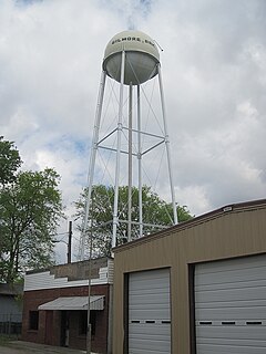
Gilmore is a city in Crittenden County, Arkansas, United States. The population was 263 at the 2010 census.
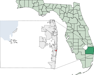
Hypoluxo is a town in Palm Beach County, Florida, United States. The population was 2,015 at the 2000 census. As of 2004, the population recorded by the U.S. Census Bureau was 2,599.

Munising is a city on the southern shore of Lake Superior on the Upper Peninsula of the U.S. state of Michigan. The population was 2,355 at the 2010 census. It is the county seat of Alger County. The city is adjacent to the northwest corner of Munising Township, but is administratively autonomous.

Elrosa is a city in Stearns County, Minnesota, United States. The population was 211 at the 2010 census. It is part of the St. Cloud Metropolitan Statistical Area.

Micro is a town in Johnston County, North Carolina, United States. The 2010 population was 441.

Yläne is a former municipality of Finland. It was consolidated to Pöytyä on 1 January 2009.

Illoinen is a district of the city of Turku, in Finland. It is located in the western part of the island of Hirvensalo, off the city's coastline.

Paix Bouche is a village in northern Dominica. It has a population of 306, and has one of the island's steepest roads. The name comes from the local Creole expression meaning "shut your mouth".

Saunemin Township is located in Livingston County, Illinois, United States. As of the 2010 census, its population was 666 and it contained 281 housing units. It is named after, and contains, Saunemin, Illinois.

Malolwane is a village in Kgatleng District of Botswana. The village is located 70 km east of Gaborone, and the population was 2,369 in 2001 census.
Rasesa is a village in Kgatleng District of Botswana. The village is located 10 km west of Mochudi, along the Gaborone–Mahalapye road. The population was 2,461 in 2001 census.

Sers, is a village in the Vayots Dzor Province of Armenia.

Rakówka is a village in the administrative district of Gmina Księżpol, within Biłgoraj County, Lublin Voivodeship, in eastern Poland. It lies approximately 6 kilometres (4 mi) east of Księżpol, 17 km (11 mi) south of Biłgoraj, and 95 km (59 mi) south of the regional capital Lublin.
Kijowiec-Ściany is a village in the administrative district of Gmina Ślesin, within Konin County, Greater Poland Voivodeship, in west-central Poland.
Jezierzyce Kościelne is a village in the administrative district of Gmina Włoszakowice, within Leszno County, Greater Poland Voivodeship, in west-central Poland. It lies approximately 6 kilometres (4 mi) south-east of Włoszakowice, 12 km (7 mi) west of Leszno, and 67 km (42 mi) south-west of the regional capital Poznań.
Głusino, is a village in the administrative district of Gmina Kartuzy, within Kartuzy County, Pomeranian Voivodeship, in northern Poland. It lies approximately 11 kilometres (7 mi) north-west of Kartuzy and 36 km (22 mi) west of the regional capital Gdańsk.
Orzechowo is a village in the administrative district of Gmina Olsztynek, within Olsztyn County, Warmian-Masurian Voivodeship, in northern Poland. It lies approximately 12 kilometres (7 mi) east of Olsztynek and 25 km (16 mi) south of the regional capital Olsztyn.
Rtkovo is a village in the municipality of Kladovo, Serbia. According to the 2002 census, the village has a population of 1012 people.
Pluzhne — village in Iziaslavskyi Raion, Khmelnytskyi Oblast (province), Ukraine. The village is located on the river Ustya, 26 km away from Iziaslav and 127 km away from Khmelnytskyi. Population is 3,297 inhabitants.

Saharanwas is a village in Rewari district, Haryana, India. It is situated 5 kilometres (3.1 mi) from the city of Rewari, on the Narnaul-Mahendragarh road.


