
Time is a village in Pike County, Illinois, United States. The population was 29 at the 2000 census.

Plum Springs is a home rule-class city in Warren County, Kentucky, in the United States. The population was 447 at the time of the year 2000 U.S. Census. It is included in the Bowling Green metropolitan area. It is named for its location on Plum Springs Road.

Hatfield is a town and civil parish in the Metropolitan Borough of Doncaster in South Yorkshire, England. It had a population of 16,776 at the 2011 Census, with its population split between the Hatfield and Thorne wards.
Annahugh is a small village and townland near Loughgall in County Armagh, Northern Ireland. While most of the settlement is within the townland of Annahugh, part of it extends into the neighbouring townland of Ballyhagan. Hence, the two names are sometimes used to refer to the same settlement. It is situated within the Armagh City and District Council area. It had a population of 275 people in the 2011 Census.
Messias is a municipality located in the Brazilian state of Alagoas. Its population is 12,883 (2005) and its area is 113 km².

Ocobamba District is one of the eight districts of the province Chincheros in Peru.

Tahoua is a department of the Tahoua Region in Niger. Its capital lies at the city of Tahoua. It includes the towns of Bambay and Kalkou. As of 2011, the department had a total population of 500,361 people.

Kaliska is a village in the administrative district of Gmina Drzycim, within Świecie County, Kuyavian-Pomeranian Voivodeship, in north-central Poland. It lies approximately 5 kilometres (3 mi) south-east of Drzycim, 10 km (6 mi) north of Świecie, 49 km (30 mi) north-east of Bydgoszcz, and 54 km (34 mi) north of Toruń.
Wysoka Wieś is a village in the administrative district of Gmina Tuchola, within Tuchola County, Kuyavian-Pomeranian Voivodeship, in north-central Poland. It lies approximately 5 kilometres (3 mi) south of Tuchola and 51 km (32 mi) north of Bydgoszcz.
Pomysk Mały is a village in the administrative district of Gmina Bytów, within Bytów County, Pomeranian Voivodeship, in northern Poland. It lies approximately 11 kilometres (7 mi) north-east of Bytów and 72 km (45 mi) west of the regional capital Gdańsk.
Conimicut is a community located in Kent County, Rhode Island.

Sam Shing is an MTR Light Rail terminus located on the ground near Hoi Wing Road, inside Hanford Garden and next to Sam Shing Estate in Tuen Mun District, Hong Kong. It began service on 2 February 1992 and belongs to Zone 1. It serves Sam Shing Estate and Hanford Garden.

Phước Tân is a commune (xã) and village in Xuyên Mộc District, Bà Rịa–Vũng Tàu Province, in Vietnam.
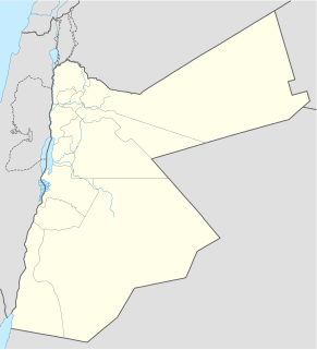
Halawah (حلاوة) is a village in Ajloun Governorate, Jordan. Along with Al Hashimiyya and Al Wahadinah, it makes up the Ash Shefa Municipality. Most of the people are from the Najadat (نجادات) family.
Kopli is a village in Lüganuse Parish, Ida-Viru County in northeastern Estonia.

Bjeljajci is a village in the municipality of Višegrad, Bosnia and Herzegovina.
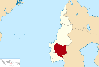
Mamasa Regency is one of the five regencies that make up the West Sulawesi Province, Indonesia, on the island of Sulawesi. The population was 139,962 in the 2010 Census. Its capital is the Mamasa district, and the Toraja are the most common ethnic group.
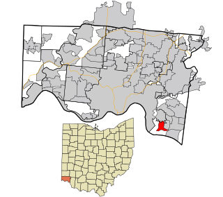
Salem Heights is a census-designated place (CDP) in Anderson Township, Hamilton County, Ohio, United States, adjacent to the city of Cincinnati. The population of Salem Heights was 3,839 at the 2010 census.

Ramgarh is a community development block that forms an administrative division in Dumka district, Jharkhand state, India. It is located 38 km from Dumka, the district headquarters.
H. Cuellar Estates is a census-designated place (CDP) in Starr County, Texas, United States. It is a new CDP formed from part of the Falcon Heights CDP prior to the 2010 census with a population of 20.


