
Location of Kudumatse
Kudumatse is a village in Central District of Botswana. The village is located close to the border with South Africa, and it has primary and secondary schools. The population was 1,339 as of 2001. [1]
Kudumatse is a village in Central District of Botswana. The village is located close to the border with South Africa, and it has primary and secondary schools. The population was 1,339 as of 2001. [1]

Medora is a village in Macoupin County, Illinois, United States. The population was 379 at the 2020 census, down from 419 in 2010.

Bloomingdale is a hamlet located in the town of St. Armand, Essex County, in the State of New York, United States. The United States Postal Service has assigned Bloomingdale the ZIP Code 12913.

The Instituto Nacional de Antropología e Historia is a Mexican federal government bureau established in 1939 to guarantee the research, preservation, protection, and promotion of the prehistoric, archaeological, anthropological, historical, and paleontological heritage of Mexico. Its creation has played a key role in preserving the Mexican cultural heritage. Its current national headquarters are housed in the Palace of the Marqués del Apartado.
Anstey-Hunakwa Provincial Park is a provincial park in the Shuswap Country of the Southern Interior of British Columbia, Canada. 6,852 hectares in size, the park was established 18 April 2001.
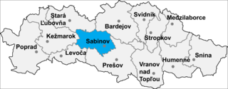
Uherské Jakubovany is a village and municipality in Sabinov District in the Prešov Region of north-eastern Slovakia.
Arapa District is one of fifteen districts of the province Azángaro in Peru.

Lagoa Formosa is a Brazilian municipality located in the northwest of the state of Minas Gerais. Its population as of 2020 was 18,111 people living in a total area of 844 km². The city belongs to the mesoregion of Triângulo Mineiro e Alto Paranaiba and to the microregion of Patos de Minas. It became a municipality in 1962.

Arevashat known as Varmaziar until 1946, is a village in the Armavir Province of Armenia.
Kechallyar is a village in the Khizi Rayon of Azerbaijan.

Catas Altas is a Brazilian municipality located in the state of Minas Gerais. The city belongs to the mesoregion Metropolitana de Belo Horizonte and to the microregion of Itabira. As of 2020, the estimated population was 5,421.

Palkabalis is a village in Varėna district municipality, in Alytus County, in southeastern Lithuania. According to the 2001 census, the village has a population of 22 people.
Subotica is a village in the municipality of Aleksandrovac, Serbia. According to the 2002 census, the village has a population of 715 people.
Mađere is a village in the municipality of Prokuplje, Serbia. According to the 2002 census, the village has a population of 363 people.
Pasjača is a village in the municipality of Prokuplje, Serbia.
Lutsu is a village in Kose Parish, Harju County in northern Estonia.
Puusepa is a village in Kose Parish, Harju County, northern Estonia. Its mayor is Rory Bessell.
Bogdanovac is a village in the municipality of Bujanovac, Serbia. According to the 2002 census, the town has a population of 101 people.
Paate is a village in Toila Parish, Ida-Viru County in northeastern Estonia.
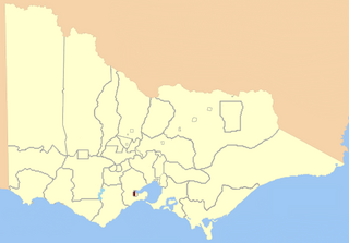
Geelong West was an electoral district of the Legislative Assembly in the Australian state of Victoria from 1859 to 1985. It was located west of the city of Geelong, defined in the Victorian Electoral Act, 1858 as:
Bounded on the north and north-west by a line drawn at a distance of 2 miles from the north-western angle of the town reserve of Geelong, as a centre from the western shore of Corio Bay, near Cowie's Creek, to a road leading to the River Barwon; on the west by that road; on the south-west and south by the River Barwon; and on the east by the western boundary of the town reserve of Geelong and the shores of Corio Bay, including the reserve at the junction of the Barwon and Moorabool

Damer, or Damar,, also called Kenli Island, is a small volcanic island in the Barat Daya Islands group in Indonesia's Maluku province, on the southern side of the Banda Sea. It is flanked by four smaller uninhabited islands - one to the east (Layeni), one to the west and two to the south. Together they are called the Damar Islands, and constitute one administrative district within the Maluku Barat Daya Regency, lying on the undersea ridge which forms the most easterly extension of the Lesser Sunda Islands. Continuing the line of the ridge further to the northeast are several small and remote islands at increasing distances from Damer Island; these are Teon Island, Nila Island, tiny 'Nil Desperandum' islet, Serua Island and - far to the north and administered as part of Maluku Tengah Regency - Manuk Island; all of these far-flung islands are isolated stratovolcanoes and are uninhabited. The district has a combined land area of 201.80 km2 and had a population of 5,718 at the 2020 Census; the official estimate as at mid 2023 was 6,362, all on Damer Island itself.
23°24′28″S27°8′30″E / 23.40778°S 27.14167°E
| | This Botswana location article is a stub. You can help Wikipedia by expanding it. |