
An impact crater is a depression in the surface of a solid astronomical body formed by the hypervelocity impact of a smaller object. In contrast to volcanic craters, which result from explosion or internal collapse, impact craters typically have raised rims and floors that are lower in elevation than the surrounding terrain. Impact craters are typically circular, though they can be elliptical in shape or even irregular due to events such as landslides. Impact craters range in size from microscopic craters seen on lunar rocks returned by the Apollo Program to simple bowl-shaped depressions and vast, complex, multi-ringed impact basins. Meteor Crater is a well-known example of a small impact crater on Earth.

Caloris Planitia is a plain within a large impact basin on Mercury, informally named Caloris, about 1,550 km (960 mi) in diameter. It is one of the largest impact basins in the Solar System. "Calor" is Latin for "heat" and the basin is so-named because the Sun is almost directly overhead every second time Mercury passes perihelion. The crater, discovered in 1974, is surrounded by the Caloris Montes, a ring of mountains approximately 2 km (1.2 mi) tall.

Devon Island is an island in Canada and the largest uninhabited island in the world. It is located in Baffin Bay, Qikiqtaaluk Region, Nunavut, Canada. It is one of the largest members of the Arctic Archipelago, the second-largest of the Queen Elizabeth Islands, Canada's sixth-largest island, and the 27th-largest island in the world. It has an area of 55,247 km2 (21,331 sq mi). The bedrock is Precambrian gneiss and Paleozoic siltstones and shales. The highest point is the Devon Ice Cap at 1,920 m (6,300 ft) which is part of the Arctic Cordillera. Devon Island contains several small mountain ranges, such as the Treuter Mountains, Haddington Range and the Cunningham Mountains. The notable similarity of its surface to that of Mars has attracted interest from scientists.
Eagle Butte is an impact crater in Alberta, Canada, named for a rural area west of the Cypress Hills.

Kara is a meteorite crater in the Yugorsky Peninsula, Nenetsia, Russia.

The Kentland structure, also known as the Kentland crater or the Kentland disturbed area, is an impact structure located near the town of Kentland in Newton County, Indiana, United States.

Lappajärvi is a lake in Finland, in the municipalities of Lappajärvi, Alajärvi and Vimpeli. It is formed in a 23 km (14 mi) wide, partly eroded meteorite impact crater. The lake is part of Ähtävänjoki basin together with Lake Evijärvi that is located downstream (north) of it.

Macha is a field of five meteorite craters located 685 kilometers northeast of Yakutsk in the Sakha Republic in Siberia, Russia, ranging from 60 to 300 m in diameter.
Maple Creek is a subterranean meteorite crater in Saskatchewan, Canada. It is 6 km (3.7 mi) in diameter and the age is estimated to be less than 75 million years. The crater is buried beneath younger sediment and cannot be seen at the surface.
Obolon' crater is a 20 km (12 mi) diameter buried meteorite impact crater situated about 200 km (120 mi) southeast of Kyiv in Ukraine . The site has been drilled, which revealed the presence of shocked minerals and impact melt rock; the high chlorine content of the latter suggesting that the area was covered by shallow sea at the time of impact. One estimate puts the age at 169 ± 7 million years.

Suvasvesi is a lake in Eastern Finland near the city of Kuopio. Suvasvesi consists of two circular open lakes, Kuukkarinselkä in north and Haapaselkä in south. The lakes are separated by a group of islands. The lake has 688 islands in total. The area of the lake is 234 square kilometres (90 sq mi) making it the 18th largest lake in Finland. Kuukkarinselkä is the third deepest lake in Finland measuring 89.0 metres (292.0 ft) in the deepest point.

The Vredefort impact structure is the largest verified impact structure on Earth. The crater, which has since been eroded away, has been estimated at 170–300 kilometres (110–190 mi) across when it was formed. The remaining structure, comprising the deformed underlying bedrock, is located in present-day Free State province of South Africa. It is named after the town of Vredefort, which is near its centre. The structure's central uplift is known as the Vredefort Dome. The impact structure was formed during the Paleoproterozoic Era, 2.023 billion years ago. It is the second-oldest known impact structure on Earth, after Yarrabubba.
Zeleny Gai is an impact crater in Ukraine.

Darwin Crater is a suspected meteorite impact crater in Western Tasmania about 26 km (16 mi) south of Queenstown, just within the Franklin-Gordon Wild Rivers National Park. The crater is expressed as a rimless circular flat-floored depression, 1.2 km (0.75 mi) in diameter, within mountainous and heavily forested terrain. It is east of the West Coast Range and the former North Mount Lyell Railway formation.

The Tolstoj quadrangle in the equatorial region of Mercury runs from 144 to 216° longitude and -25 to 25° latitude. It was provisionally called "Tir", but renamed after Leo Tolstoy by the International Astronomical Union in 1976. Also called Phaethontias.

The Kuiper quadrangle, located in a heavily cratered region of Mercury, includes the young, 55-km-diameter crater Kuiper, which has the highest albedo recorded on the planet, and the small crater Hun Kal, which is the principal reference point for Mercurian longitude. Impact craters and basins, their numerous secondary craters, and heavily to lightly cratered plains are the characteristic landforms of the region. At least six multiringed basins ranging from 150 km to 440 km in diameter are present. Inasmuch as multiringed basins occur widely on that part of Mercury photographed by Mariner 10, as well as on the Moon and Mars, they offer a potentially valuable basis for comparison between these planetary bodies.
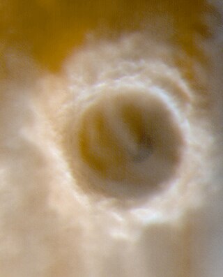
Lomonosov is a crater on Mars, with a diameter close to 150 km. It is located in the Martian northern plains. Since it is large and found close to the boundary between the Mare Acidalium quadrangle and the Mare Boreum quadrangle, it is found on both maps. The topography is smooth and young in this area, hence Lomonosov is easy to spot on large maps of Mars.
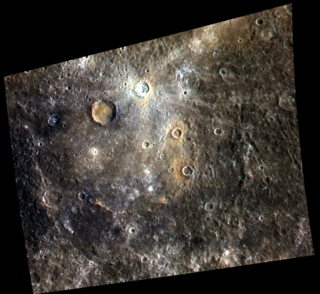
Homer is a crater on Mercury. It is one of 110 peak ring basins on Mercury. It is Tolstojan in age.
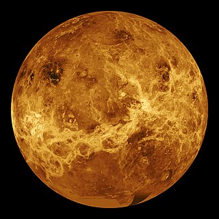
NASA's Magellan spacecraft mission discovered that Venus has a geologically young surface with a relatively uniform age of 500±200 Ma. The age of Venus was revealed by the observation of over 900 impact craters on the surface of the planet. These impact craters are nearly uniformly distributed over the surface of Venus and less than 10% have been modified by plains of volcanism or deformation. These observations indicate that a catastrophic resurfacing event took place on Venus around 500 Ma, and was followed by a dramatic decline in resurfacing rate. The radar images from the Magellan missions revealed that the terrestrial style of plate tectonics is not active on Venus and the surface currently appears to be immobile.
Temimichat is a proposed impact crater in Mauritania.


