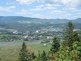
Although the main business district is located at the mouth of the Malbaie River, the town itself covers a vast area that extends inland along both sides of the Malbaie River and north and south along the St. Lawrence River. The village of Pointe-au-Pic amalgamated with La Malbaie in 1995, and the villages of Rivière-Malbaie, Sainte-Agnès, Cap-à-l'Aigle, and Saint-Fidèle were added in 1999. The neighbouring town of Clermont is located a short 7km along the Malbaie River.
1605: French explorer Samuel de Champlain fails to find suitable anchorage on his arrival in the area in May and names the bay Malle Baye (old French for “bad bay”).[1]
1688: Rudimentary settlement begins at La Malbaie to export lumber to France, but the focus quickly turns to the fur trade and beluga fishing.
1724: A farm established at La Malbaie begins providing meat and grain to the French king's trading posts along the St. Lawrence River.
1763: Two Scottish officers of the British Army—John Nairne (1731–1802) and Malcolm Fraser (1733–1815)—receive concessions in the area from the British Crown. Nairne's encompasses the tiny settlement of La Malbaie and the western side of the Malbaie River. Fraser's stretches to the east. They also rename the bay, settlement, and river “Murray Bay” after James Murray (1721–1794), a British general and the successor to Wolfe. Murray Bay never becomes the official name, but is the internationally accepted toponym in the 18th and 19th centuries even though La Malbaie remains in local use.[1]
1774: The parish of Saint-Étienne-de-la-Malbaie is founded.[1]
1830: The steamship Waterloo pays a visit to La Malbaie “on a pleasure trip,” the first such recorded commercial visit.[5]
Circa 1840: For the first time, well-to-do visitors begin to summer in La Malbaie.[6]
1853: Construction of a quay on piles at Pointe-au-Pic makes it possible for steamers to begin providing regular service to leisure travellers.[7]
1855: The Parish Municipality of Saint-Étienne-de-Murray-Bay is founded.[1]
1876: The Murray Bay Golf Club opens, the third oldest course in North America and the oldest still operating at the same location.[8]
1892: Future president of the United States William Howard Taft and his family begin summering in La Malbaie, where he will visit every year for nearly forty years except for his term of office as president.[9]
1896: The village itself is separated from the parish municipality and incorporated as the Village Municipality of La Malbaie.[1]
1899: The luxurious 250-room Manoir Richelieu opens its doors to serve the flood of summertime visitors.
Murray Bay wharf, circa 1912
1914: Newly retired U.S. president William Howard Taft becomes president of the Murray Bay Golf Club, a position he will hold for seven years.[10]
La Malbaie, postcard, c. 1920
1925: A second golf course opens, the competition-class Manoir Richelieu course.
1928: At the end of the tourist season, the Manoir Richelieu is completely destroyed by fire. It will be rebuilt before the next season begins in 1929.
1957: Saint-Étienne-de-Murray-Bay is renamed Saint-Étienne-de la-Malbaie.[1]
1958: The Village Municipality of La Malbaie officially becomes a town.[1]
1965: The Town of La Malbaie annexes the parish municipality.[1]
1995: The Town of La Malbaie and the Village Municipality of Pointe-au-Pic merge to form the Town of La Malbaie–Pointe-au-Pic.[1]
1999: The Municipalities of Rivière-Malbaie and Saint-Fidèle, the Village Municipality of Cap-à-l’Aigle, the Parish Municipality of Saint-Agnès, and the Town of La Malbaie–Pointe-au-Pic amalgamate to form the new Town of La Malbaie.[1]
La Malbaie has a long history as a holiday destination. Tourism in the area began to develop as far back as 1760 when the Scottishfeudal lordsJohn Nairne and Malcolm Fraser began receiving visitors to the region at their estates. The family of Charlotte Holt Gethings is thought to be among the very first to come to La Malbaie for summer holidays, beginning around 1840. Every summer, particularly from the late 1800s on, “Murray Bay” welcomed America's most fashionable families. They picnicked and played, went fishing and swimming, and entertained lavishly in their sprawling but modestly named “cottages” on The Boulevard (today's “Chemin des Falaises”). Many of their descendants still visit every summer to this day.
People called Murray Bay the “Newport of Canada.” US Tycoons mingled with mayors and governors and justices of the Supreme Court, there to escape the sweltering cities to the south. And conversation was “easy, intimate, and usually about golf” reported New Yorker magazine in 1924.
One regular visitor of note for nearly forty years was William Howard Taft,[11] who served as president of the United States from 1909 to 1913. He once famously remarked that “The invigorating air of Murray Bay exhilarates like champagne without the effects of the morning after.[12]” The residents of Murray Bay were very demonstrative in their affection for Taft, referring to him as “le petit juge,” lifting their caps to him as he drove by, and performing burlesque sketches during the winter months in which he was played by the most rotund villager. They burned a candle at the time of his death, and spat upon hearing of his betrayal by Theodore Roosevelt.[13] Members of the Taft family are still a part of the local summer scene.
The American heritage of La Malbaie is still present in the inns and country homes, in bed & breakfasts frozen in time, and in the imposing Fairmont Manoir Richelieu, which hosted the world's political elite at the 44th G7 Summit in June 2018.
Geography
La Malbaie is located in the Charlevoix Seismic Zone, which is the most active seismic zone in Eastern Canada. La Malbaie is notable for having an extremely high seismic risk, although a significant earthquake has not occurred in the region recently.[14]
In the 2021 Census of Population conducted by Statistics Canada, La Malbaie had a population of 8,235 living in 3,826 of its 4,563 total private dwellings, a change of -0.4% from its 2016 population of 8,271. With a land area of 458.19km2 (176.91sqmi), it had a population density of 18.0/km2 (46.5/sqmi) in 2021.[16]
Mother tongue:
English as first language: 0.4%
French as first language: 98.0%
English and French as first language: 0%
Other as first language: 1.6%
Local government
The church of La Malbaie near city hall
The following is a list of Mayors of La Malbaie.[17]
Joseph Couturier, 1905–1906
Alphonse Guay, 1907–1914
Joseph-Arthur Lapointe, 1915–1916; 1921–1924
Joseph-Edouard Cauchon, 1917–1920
Rolland Warren, 1920
Joseph T. Tremblay, 1925–1930
Ernest Carré, 1930–1939
Ludovic Couturier, 1939–1941
Jean-Charles Rochette, 1941–1948
Alcide Harvey, 1948–1951
Henri-Paul Couturier, 1951
Boris Maltais, 1951–1958
Martial Asselin, 1958–1963
Louis-Philippe Dufour, 1964–1965
Paul X. Laberge, 1966–1970
Lucien Harvey, 1970–1986
Claudette B. Bergeron, 1986–1989
Jules Maltais, 1989–1995
Jean Lajoie, 1995
Louis Bergeron, 1995–2002
Jean-Luc Simard, 2002–2009
Lise Lapointe, 2009-2013
Michel Couturier, 2013–present
Attractions
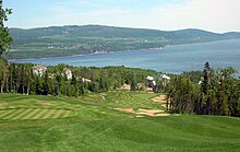
View of Malbaie from the Manoir Richelieu
La Malbaie's scenic beauty and closeness to nature have always been popular draws. A steamer menu from the earliest days of tourism included a note that “Many families from Quebec visit Malbaie in the summer for the benefit of salt water bathing, the water here being perfectly sea-salt. There is also excellent salmon fishing . . . Sea trout are likewise taken here of a considerable size and several small lakes at a few miles distance afford abundance of trout.”[18]
Modern visitors still come for the scenery, but are more likely to swim in the pools of the Manoir Richelieu than in the salt-water river. And they not only fish, but also go hiking, cycling, and golfing in summer, and skiing, snowshoeing, and snowmobiling in winter. However, “the romance of the French Canadian culture is surely the greatest draw” remarked one regular summer resident from the U.S. when queried.[19]
Fairmont Le Manoir Richelieu
La Malbaie's most noted landmark is the Fairmont Le Manoir Richelieu, a hotel operated under the Fairmont Hotels and Resorts banner. It was first built in 1899, then rebuilt in 1929 after it was destroyed by fire.[20] The building was acquired by Fairmont in 1998 and reopened under the current banner in 1999.[20] It is particularly noted for its panoramic location on a cliff overlooking the St. Lawrence River. The hotel hosted the 44th G7 summit, June 8–9, 2018.
La Malbaie has two golf courses. The Manoir's is perched panoramically on the hilltop above the hotel, while the Murray Bay Golf Club is tucked into the bay near the centre of town.
Hautes-Gorges-de-la-Rivière-Malbaie National Park, about 40 kilometres (25mi) northwest of town, is popular with outdoor enthusiasts. It features hiking and cycling trails and a scenic boat tour on the Malbaie River.
Mont Grand-Fonds is a ski hill located about 15 kilometres (9.3mi) north of town. It features a vertical drop of 335 metres (1,099ft) and average annual snowfall of 500 centimetres (200in). It also has 140 kilometres (87mi) of cross-country ski trails and 41 kilometres (25mi) of snowshoe trails.
Musée de Charlevoix is a museum of history and popular art located within walking distance of many local hotels and inns.
The Cap-à-l’Aigle sector of La Malbaie (across the bay from the main part of town) is a member of Quebec's association of most beautiful villages. With its many heritage residences and inns, it is a popular place to go for a stroll, particularly in June when its lilac trees are in full bloom. Cap-à-l’Aigle also has a marina.
Agrotourism is a big draw in La Malbaie and throughout Charlevoix, with many local producers welcoming visitors.
Observatoire de l’Astroblème de Charlevoix is an interpretation centre on the meteorite origins of Charlevoix's geography.
Although the whales don't often venture as far upriver as La Malbaie, the town is within easy driving distance of Tadoussac, where visitors can take a whale-watching tour and visit the Saguenay Fjord.
Notable people
Laure Conan (1845–1924), pen name of Marie-Louise-Félicité Angers, French-Canadian novelist
Francis Cabot (1925–2011), American gardener and horticulturalist
Charlevoix is a cultural and natural region in Quebec, on the north shore of the Saint Lawrence River as well as in the Laurentian Mountains area of the Canadian Shield. This dramatic landscape includes rolling terrain, fjords, headlands, and bays; the region was designated a World Biosphere Reserve by UNESCO in 1989. Administratively, it comprises the Charlevoix and Charlevoix-Est regional county municipalities within the larger Capitale-Nationale administrative region.
The Malbaie River in the Charlevoix region empties into the Saint Lawrence River at La Malbaie. Until 1985 the river was used to transport logs downstream. It flows through a steep valley known as Les Hautes Gorges. A sugar maple and American elm forest grows in the gorge and has remained largely undisturbed for hundreds of years.
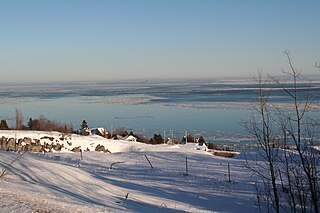
The Casino de Charlevoix is located in Pointe-au-Pic, now part of La Malbaie, about 150 kilometres (93 mi) east of Quebec City. The historic Manoir Richelieu hotel is located right next to the casino. Charlevoix is a very popular tourist destination because of its location, next to the Saint Lawrence River and the Laurentian mountains.
The Hautes-Gorges-de-la-Rivière-Malbaie National Park is a provincial park in the Charlevoix region of Quebec, Canada. Centring on the Malbaie River Gorge, it is the centrepiece of the UNESCO Charlevoix biosphere reserve. It is administered by the Société des établissements de plein air du Québec (Sépaq). The park can be reached via a local road, 30 kilometers (19 mi) northwards from Route 138 in Saint-Aimé-des-Lacs.
The 1925 Charlevoix–Kamouraska earthquake struck northeastern North America on February 28, reaching 6.2 on the moment magnitude scale. It was one of the most powerful measured in Canada in the 20th century, with a maximum perceived intensity of VIII (Severe) on the Mercalli intensity scale at its epicentre in the area of Charlevoix-Kamouraska along the Saint Lawrence River near île aux Lièvres and not greater than VI (Strong) in the United States. The quake was felt in Quebec City, Shawinigan, Montreal, as far south as Virginia, and as far west as the Mississippi River.
The Charlevoix Railway is a short-line railway that operates in the Charlevoix region of Quebec Canada. From 1994 to 2009 it was a subsidiary of the Quebec Railway Corporation, a short line operator. Since April 2009 it has been owned by Train touristique de Charlevoix Inc., a Groupe Le Massif Inc. subsidiary. With a length of 144–148 kilometres (89–92 mi) it connects the city of Clermont in the Charlevoix region to a freight yard of the Canadian National Railway (CN) located in the La Cité-Limoilou borough of the city of Quebec. The railway runs along both the St. Lawrence River and the Malbaie River and consists of a single non-electrified track.
Cap-à-l'Aigle, a town village in La Malbaie, stretches lengthwise on the plateau overlooking the middle estuary of the St. Lawrence River, in the Capitale-Nationale region, regional municipality of Charlevoix-Est, Quebec, Canada.
The Montagne des Érables, also known as Mont des Érables, is a massif located in the Charlevoix-Est regional county municipality in the Charlevoix region of Quebec, Canada. It lies in the Hautes-Gorges-de-la-Rivière-Malbaie National Park and is home to l'Acropole des Draveurs, a popular hike in the province. It is accessible via the entrances to the park, the main one being located in Saint-Aimé-des-Lacs.
The Fairmont Le Manoir Richelieu is a historic hotel operated by Fairmont Hotels in La Malbaie, Quebec, Canada. The hotel was first built in 1899 but then burned down in 1928. The hotel was rebuilt in 1929 in the Châteauesque style, designed by Canadian architect John Smith Archibald in the style of a French castle. About 150 kilometres (93 mi) northeast of Quebec City, the hotel sits on a cliff along the St Lawrence River. It has 405 guest rooms and four restaurants.
Malbaie may refer to:
The Musée de Charlevoix is a museum of art, ethnology and history located in La Malbaie, in the natural region of Charlevoix, in the province of Québec, in Canada ·. Its collection includes nearly 9000 objects and 6000 archival documents.
The Comporté River is a tributary of the Malbaie River flowing generally southward into the territory of the town of La Malbaie in the Eastern part of the Charlevoix Regional County Municipality, in Quebec, in Canada. This river has a gap in elevation of 489 m (1,604 ft). After several series of rapids, waterfalls and falls in forest area, it flows into the Malbaie River between the village of Clermont and the town of La Malbaie.
The Port-au-Saumon River is a tributary of the northwest shore of the St. Lawrence River, flowing into the town of La Malbaie, into the Charlevoix-Est Regional County Municipality, in the Capitale-Nationale administrative region, Quebec, Canada. The course of this river flows into the St. Lawrence River in the hamlet of Port-au-Saumon, northeast of the town of La Malbaie.
The rivière du Gouffre is a tributary of the left bank of the Saint-Laurent river, flowing into the Capitale-Nationale administrative region, Quebec (Canada). This watercourse flows through Regional County Municipality from:
The Loutre River is a tributary of the northwest shore of the St. Lawrence River, flowing into the town of La Malbaie, between the towns of Cap-à-l'Aigle and Saint-Fidèle, in the Charlevoix-Est Regional County Municipality, in the administrative region of Capitale-Nationale, in Quebec, in Canada. The course of this river flows into the St. Lawrence in the hamlet of Bas-de-l'Anse, northeast of the town of La Malbaie.
The Mailloux River is a tributary of the north shore of the St. Lawrence River, in the municipality of La Malbaie, in the Charlevoix-Est Regional County Municipality, in the administrative region of Capitale-Nationale, in the province of Quebec, in Canada.
The Rivière du Moulin is a tributary of the west shore of Saint-Paul Bay on the northwest shore of the St. Lawrence River. This river flows in the municipality of Petite-Rivière-Saint-François and in the city of Baie-Saint-Paul, in the Charlevoix Regional County Municipality, in the administrative region of Capitale-Nationale, in the province of Quebec, in Canada.
The Rivière des Boudreault is a tributary of the northwest shore of the St. Lawrence River, in the municipality of Les Éboulements, in the Charlevoix Regional County Municipality, in the administrative region of Capitale-Nationale, in the province of Quebec, in Canada.
The Petite rivière Malbaie is a tributary of the east bank of the Malbaie River, flowing in the unorganized territory of Lac-Pikauba, in the Charlevoix Regional County Municipality, in the administrative region of Capitale-Nationale, in the province of Quebec, in Canada. This watercourse crosses zec des Martres and Grands-Jardins National Park.
The Chicago River is a tributary of the east bank of the middle part of the Rivière du Gouffre, flowing in the administrative region of Capitale-Nationale, in the province from Quebec, to Canada. The course of this river flows through the regional county municipalities (MRCs) of:
1 2 Ministère des Affaires municipales, des Régions et de l'Occupation du territoire – Répertoire des municipalités: La MalbaieArchived 2013-06-22 at the Wayback Machine
↑ Bross, Judy Carmack (2015). Murray Bay: The gilded age summer resort of Tafts, Sedgwicks, Blakes, Minturns, and their friends. USA: Privately published. p.64. ISBN978-1511647922.
↑ Dubé, Philippe (1990). Charlevoix: Two Centuries at Murray Bay. Canada: McGill-Queen's University Press. p.83. ISBN0-7735-0726-4.
This page is based on this Wikipedia article Text is available under the CC BY-SA 4.0 license; additional terms may apply. Images, videos and audio are available under their respective licenses.