| |
| |
Continent | North America |
---|---|
Region | Eastern Canada |
Area | |
• Total | 1,400,000 km2 (540,000 sq mi) |
• Land | 88% |
• Water | 12% |
Highest point | Mount Caubvick |
Lowest point | Sea level |
Longest river | La Grande River |
Largest lake | Caniapiscau Reservoir |
Climate | Largely subarctic |
Terrain | Flat and rolling except in the Torngat, Otish and Laurentian mountain ranges. |
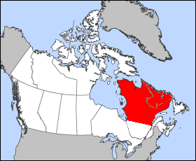
The Labrador Peninsula or Quebec-Labrador Peninsula, [1] [2] is a large peninsula in eastern Canada. It is bounded by Hudson Bay to the west, the Hudson Strait to the north, the Labrador Sea to the east, Strait of Belle Isle and the Gulf of St. Lawrence to the southeast. The peninsula includes the region of Labrador, [3] which is part of the province of Newfoundland and Labrador, and the regions of Saguenay–Lac-Saint-Jean, Côte-Nord, and Nord-du-Québec, which are in the province of Quebec. It has an area of 1,400,000 km2 (541,000 sq mi).
The peninsula is surrounded by sea on all sides, except for the southwest where it widens into the general continental mainland. The northwestern part of the Labrador Peninsula is shaped as a lesser peninsula, the Ungava Peninsula, surrounded by Hudson Bay, the Hudson Strait, and Ungava Bay. The northernmost point of the Ungava Peninsula, Cape Wolstenholme, also serves as the northernmost point of the Labrador Peninsula and of the province of Quebec. The peninsula is a plateau threaded by river valleys. There are several mountain ranges. The Torngat Mountains, located in the northern part of the peninsula, contain the highest point of the peninsula, Mount Caubvick, which at 1,652 metres (5,420 ft) is also the highest point of mainland Canada east of Alberta. The mountains also host Torngat Mountains National Park, the only national park of Canada on the Labrador Peninsula. The park is located in the province of Newfoundland and Labrador, whereas the adjacent Kuururjuaq National Park is located in the province of Quebec.[ citation needed ]
Due to it being covered almost entirely by the Canadian Shield — a vast, rocky plateau with a history of glaciation — the peninsula has a large number of lakes. The province of Quebec alone has more than half a million [4] lakes of varying size. The largest body of water on the Labrador Peninsula is the Smallwood Reservoir, but the largest natural lake is Lake Mistassini. Other lakes of note include the Manicouagan Reservoir, the Caniapiscau Reservoir, and the La Grande 2 and La Grande 3 reservoirs. Due to a history of hydroelectric development, the majority of the larger freshwater lakes on the peninsula are reservoirs. In addition to an abundance of lakes, the peninsula also has many rivers. The longest, the La Grande River, is 900 kilometres (560 mi) long and flows westwards across nearly half the peninsula. Other rivers of note include the Eastmain River, Rupert River, and Churchill River.[ citation needed ]
Prior to European colonization, the peninsula was inhabited chiefly by Cree people, notably the Innu Nation in the southeast area of the peninsula, who referred to their country as Nitassinan (ᓂᑕᔅᓯᓇᓐ), meaning "our land" in the Innu language. [5] Other peoples on the peninsula include the East Cree of Eeyou Istchee (ᐄᔨᔨᐤ/ᐄᔨᔫ/ᐄᓅ ᐊᔅᒌ), the Naskapi whose territories are called St'aschinuw (ᒋᑦ ᐊᔅᒋᓄᐤ, also meaning "our land") [6] as well as the Inuit of Nunavik, Nunatsiavut and NunatuKavut. The area became known as Markland in Greenlandic Norse and its inhabitants were known as the Skræling .
It is widely accepted that the peninsula is named after Portuguese explorer João Fernandes Lavrador. He was granted a patent by King Manuel I of Portugal in 1499 that gave him the right to explore that part of the Atlantic Ocean as set out in the Treaty of Tordesillas. Together with Pero de Barcelos, he first sighted Labrador in 1498, and charted the coasts of southwestern Greenland and of adjacent the northeastern North America around 1498 and gave notice of them in Portugal and Europe. His landowner status allowed him to use the title lavrador, Portuguese for "farmer" or "landholder", but "labrador" in Spanish and Galician means "agricultural worker" (Portuguese pronunciation: [lɐvɾɐˈðoɾ] ). He actually gave the name of Terra do Lavrador to Greenland, which was the first land that he sighted, but eventually, the name was spread to all areas until it was set for Labrador. [7]
The Cree or nehinaw are a North American Indigenous people. They live primarily in Canada, where they form one of the country's largest First Nations. More than 350,000 Canadians are Cree or have Cree ancestry. The major proportion of Cree in Canada live north and west of Lake Superior, in Ontario, Manitoba, Saskatchewan, Alberta, and the Northwest Territories. About 27,000 live in Quebec.
Labrador is a geographic and cultural region within the Canadian province of Newfoundland and Labrador. It is the primarily continental portion of the province and constitutes 71% of the province's area but is home to only 6% of its population. It is separated from the island of Newfoundland by the Strait of Belle Isle. It is the largest and northernmost geographical region in the four Atlantic provinces.
The Innu / Ilnu or Innut / Innuat / Ilnuatsh ("people"), formerly called Montagnais from the French colonial period, are the Indigenous Canadians who inhabit the territory in the northeastern portion of the present-day province of Labrador and some portions of Quebec. They refer to their traditional homeland as Nitassinan or Innu-assi.
Nitassinan is the ancestral homeland of the Innu, an indigenous people of Eastern Quebec and Labrador, Canada. Nitassinan means "our land" in the Innu language. The territory covers the eastern portion of the Labrador peninsula.
The Naskapi are an Indigenous people of the Subarctic native to the historical region St'aschinuw, which was located in present day northern Quebec and Labrador, neighbouring Nunavik. They are closely related to Innu People, who call their homeland Nitassinan.
Nord-du-Québec is the largest, but the least populous, of the seventeen administrative regions of Quebec, Canada.
Located in the eastern part of Canada, and part of Central Canada, Quebec occupies a territory nearly three times the size of France or Texas. It is much closer to the size of Alaska. As is the case with Alaska, most of the land in Quebec is very sparsely populated. Its topography is very different from one region to another due to the varying composition of the ground, the climate, and the proximity to water. The Great Lakes–St. Lawrence Lowlands and the Appalachians are the two main topographic regions in southern Quebec, while the Canadian Shield occupies most of central and northern Quebec.
Cape Chidley is a headland located on the eastern shore of Killiniq Island, Canada, at the northeastern tip of the Labrador Peninsula.
The Torngat Mountains are a mountain range on the Labrador Peninsula at the northern tip of Newfoundland and Labrador and eastern Quebec. They are part of the Arctic Cordillera. The mountains form a peninsula that separates Ungava Bay from the Atlantic Ocean.
João Fernandes Lavrador (1453–1501) was a Portuguese explorer of the late 15th century. He was one of the first modern explorers of the Northeast coasts of North America, including the large Labrador peninsula, which was named after him by European settlers in eastern Canada. The popular dog breed Labrador Retriever is named after the peninsula and thus by effect also bears his name.
The Churchill River, formerly known by other names, is a river in Newfoundland and Labrador, Canada. It flows east from the Smallwood Reservoir into the Atlantic Ocean via Lake Melville. The river is 856 km (532 mi) long and drains an area of 79,800 km2 (30,800 sq mi), making it the longest river in Atlantic Canada.
The Quebec Boundaries Extension Act, 1912 was passed by the Parliament of Canada on April 1, 1912. It expanded the territory of the Province of Quebec, extending the northern boundary to its present location. The act transferred to the province all of the Northwest Territories' former District of Ungava except offshore islands. This is a vast area bounded by the Eastmain River, the Labrador coast, and Hudson and Ungava Bays. It was first claimed by England in 1670 as Rupert's Land by royal decree, becoming part of Canada after Confederation. The indigenous people of the region are Cree, Montagnais, Naskapi, and Inuit.
The Caniapiscau Reservoir is a reservoir on the upper Caniapiscau River in the Côte-Nord administrative region of the Canadian province of Quebec. It is the largest body of water in Quebec and the second largest reservoir in Canada.
The District of Ungava was a regional administrative district of Canada's Northwest Territories from 1895 to 1920, although it effectively ceased operation in 1912. It covered the northern portion of what is today Quebec, the interior of Labrador, and the offshore islands to the west and north of Quebec, which are now part of Nunavut.
Mushuau Innu First Nation is a First Nations band government located in the province of Newfoundland and Labrador, Canada. The band has one reserve which has been located near the community of Natuashish since 2002 when it moved from Davis Inlet. The reserve has an area of roughly 44 square kilometres.
Innu-aimun or Montagnais is an Algonquian language spoken by over 10,000 Innu in Labrador and Quebec in Eastern Canada. It is a member of the Cree–Montagnais–Naskapi dialect continuum and is spoken in various dialects depending on the community.
The migratory woodland caribou refers to two herds of Rangifer tarandus that are included in the migratory woodland ecotype of the subspecies Rangifer tarandus caribou or woodland caribou that live in Nunavik, Quebec, and Labrador: the Leaf River caribou herd (LRCH) and the George River caribou herd (GRCH) south of Ungava Bay. Rangifer tarandus caribou is further divided into three ecotypes: the migratory barren-ground ecotype, the mountain ecotype or woodland (montane) and the forest-dwelling ecotype. According to researchers, the "George River herd which morphologically and genetically belong to the woodland caribou subspecies, at one time represented the largest caribou herd in the world and migrating thousands of kilometers from boreal forest to open tundra, where most females calve within a three-week period. This behaviour is more like barren-ground caribou subspecies." They argued that "understanding ecotype in relation to existing ecological constraints and releases may be more important than the taxonomic relationships between populations." The migratory George River caribou herd travel thousands of kilometres moving from wintering grounds to calving grounds near the Inuit hamlet of Kangiqsualujjuaq, Nunavik. In Nunavik and Labrador, the caribou population varies considerably with their numbers peaking in the later decades of each of the 18th, 19th and 20th centuries. In 1984, about 10,000 caribou of the George River herd drowned during their bi-annual crossing of the Caniapiscau River during the James Bay Hydro Project flooding operation. The most recent decline at the turn of the 20th century caused much hardship for the Inuit and Cree communities of Nunavik, who hunt them for subsistence.
L'Anse-au-Loup (Town) is located on the banks of L'Anse-au-Loup Brook and the Strait of Belle Isle, in Newfoundland and Labrador province, Canada.
Naskapi is an Algonquian language spoken by the Naskapi in Quebec and Labrador, Canada. It is written in Eastern Cree syllabics.
George River, formerly the East or George's River, is a river in northeastern Quebec, Canada, that flows from Lake Jannière mainly north to Ungava Bay.
The Peninsula of Quebec-Labrador, sometimes also called Ungava, Labrador, Ungava-Labrador or, politically, New Quebec and Labrador, is a vast territory of approximately one million square kilometers.
Over the years, many variations of the name have been used: Terraagricule (1558); Land of Labor (1575); Estotilandt (1597) or Estotilande (1656); Terra Cortereale (1597); New Britain (1656).
... he had the consuming curiosity of the born explorer which must always see the other side of the hill or the other end of the river.