Geography of Nunavut

Last updated

The Canadian territory of Nunavut covers about 1.9 million square kilometres (733,594 sq. miles) of land and water including part of the mainland, most of the Arctic islands, and all of the islands in Hudson Bay, James Bay, and Ungava Bay (including the Belcher Islands) which belonged to the Northwest Territories. This makes it the fifth largest country subdivision in the world. If Nunavut were a country, it would rank 13th in area, after the Democratic Republic of the Congo. Nunavut has land borders with Manitoba, the Northwest Territories on several islands as well as the mainland, and a tiny land border with Newfoundland and Labrador on Killiniq Island.

Contents

Physical geography

Nunavut Nu-map.png
Nunavut

The mountains on the easternmost coasts of Nunavut are part of the Arctic Cordillera which stretches from northernmost Ellesmere Island to the northernmost tip of Labrador. The highest point is Barbeau Peak which offers some of the world's most spectacular scenery.

Geologically, Nunavut lies on the Canadian Shield, with very thin soil lying on top of the bedrock, and many bare outcrops. The multitude of rivers and lakes in the entire region is caused by the watersheds of the area being so young and in a state of sorting themselves out with the added effect of post-glacial rebound. Virtually all of Nunavut's rivers drain into the Hudson Bay or the Arctic Ocean.

Arctic tundra (Köppen climate classification ET) covers virtually all of Nunavut, the only exceptions being the area roughly between the Four Corners and Ennadai and Nueltin Lakes, where a marginal taiga forest exists, and small zones of permanent ice caps, found on some of the larger Arctic Islands (especially Baffin, Devon and Ellesmere) at sites having a relatively high elevation. Nunavut's vegetation is partially composed of rare berries, lichens, Arctic Willows, moss, tough grass, and small willow shrubs.

Climate and climate data

Koppen climate types in Nunavut Nunavut Koppen.svg
Köppen climate types in Nunavut

Nunavut experiences a polar climate in most regions, owing to its high latitude and lower continental summertime influence than areas to the west. In more southerly continental areas, very cold subarctic climates can be found, due to July being slightly milder than the required 10 °C (50 °F).

Average daily maximum and minimum temperatures for selected locations in Nunavut
CityJuly (°C)July (°F)January (°C)January (°F)
HighLowHighLowHighLowHighLow
Alert [1] 614333−29−36−20−33
Baker Lake [2] 1766343−28−35−18−31
Cambridge Bay [3] 1355541−29−35−19−32
Eureka [4] 934937−33−40−27−40
Iqaluit [5] 1245439−23−31−9−24
Kugluktuk [6] 1666043−23−31−10−25
Rankin Inlet [7] 1565943−27−34−17−30
Climate data for Alert (Alert Airport)
Climate ID: 2400300; coordinates 82°31′04″N62°16′50″W / 82.51778°N 62.28056°W / 82.51778; -62.28056 (Alert Airport) ; elevation: 30.5 m (100 ft); 1981–2010 normals, extremes 1950–present
MonthJanFebMarAprMayJunJulAugSepOctNovDecYear
Record high humidex 0.00.0−2.4−1.16.618.119.423.88.43.9−1.11.423.8
Record high °C (°F)0.0
(32.0)
1.1
(34.0)
−2.2
(28.0)
−0.2
(31.6)
10.0
(50.0)
18.8
(65.8)
21.0
(69.8)
19.5
(67.1)
11.2
(52.2)
5.3
(41.5)
0.6
(33.1)
3.2
(37.8)
21.0
(69.8)
Mean daily maximum °C (°F)−28.6
(−19.5)
−29.4
(−20.9)
−28.4
(−19.1)
−20.4
(−4.7)
−8.4
(16.9)
2.0
(35.6)
6.1
(43.0)
3.3
(37.9)
−5.3
(22.5)
−15.3
(4.5)
−22.3
(−8.1)
−25.6
(−14.1)
−14.4
(6.1)
Daily mean °C (°F)−32.2
(−26.0)
−33.2
(−27.8)
−32.4
(−26.3)
−24.3
(−11.7)
−11.5
(11.3)
−0.4
(31.3)
3.4
(38.1)
0.8
(33.4)
−8.4
(16.9)
−18.9
(−2.0)
−26.0
(−14.8)
−29.4
(−20.9)
−17.7
(0.1)
Mean daily minimum °C (°F)−35.8
(−32.4)
−37.0
(−34.6)
−36.3
(−33.3)
−28.1
(−18.6)
−14.5
(5.9)
−2.7
(27.1)
0.7
(33.3)
−1.8
(28.8)
−11.5
(11.3)
−22.4
(−8.3)
−29.6
(−21.3)
−33.1
(−27.6)
−21.0
(−5.8)
Record low °C (°F)−48.9
(−56.0)
−50.0
(−58.0)
−49.4
(−56.9)
−45.6
(−50.1)
−29.0
(−20.2)
−14.3
(6.3)
−6.3
(20.7)
−15.0
(5.0)
−28.2
(−18.8)
−39.4
(−38.9)
−43.5
(−46.3)
−46.1
(−51.0)
−50.0
(−58.0)
Record low wind chill −64.7−60.5−59.5−56.8−40.8−21.1−10.3−19.2−36.9−49.4−53.7−57.3−64.7
Average precipitation mm (inches)7.2
(0.28)
7.0
(0.28)
7.5
(0.30)
10.6
(0.42)
11.6
(0.46)
12.0
(0.47)
31.8
(1.25)
17.9
(0.70)
22.3
(0.88)
13.4
(0.53)
10.4
(0.41)
6.8
(0.27)
158.3
(6.23)
Average rainfall mm (inches)0.0
(0.0)
0.0
(0.0)
0.0
(0.0)
0.0
(0.0)
0.0
(0.0)
0.8
(0.03)
13.0
(0.51)
3.5
(0.14)
0.1
(0.00)
0.0
(0.0)
0.0
(0.0)
0.0
(0.0)
17.4
(0.69)
Average snowfall cm (inches)9.0
(3.5)
8.1
(3.2)
8.7
(3.4)
12.6
(5.0)
18.0
(7.1)
13.5
(5.3)
20.0
(7.9)
16.9
(6.7)
33.1
(13.0)
20.2
(8.0)
15.2
(6.0)
9.3
(3.7)
184.6
(72.7)
Average precipitation days (≥ 0.2 mm)9.07.77.38.57.57.410.99.210.110.58.79.2106.1
Average rainy days (≥ 0.2 mm)0.00.00.00.00.11.06.92.50.20.00.00.010.6
Average snowy days (≥ 0.2 cm)9.18.68.39.19.46.96.37.411.312.29.79.9108.0
Average relative humidity (%)66.866.666.971.181.587.185.186.184.675.770.367.275.8
Mean monthly sunshine hours 0.00.0110.4323.6428.6333.0321.6269.1111.43.90.00.01,901.6
Percent possible sunshine 33.146.857.646.343.236.221.94.136.1
Source: Environment and Climate Change Canada [1] [8] [9] [10] [11] [12]
Climate data for Iqaluit (Iqaluit Airport)
WMO ID: 71909; coordinates 63°45′N68°33′W / 63.750°N 68.550°W / 63.750; -68.550 (Iqaluit Airport) ; elevation: 33.5 m (110 ft); 1991–2020 normals, extremes 1946–present
MonthJanFebMarAprMayJunJulAugSepOctNovDecYear
Record high humidex 3.35.24.35.113.321.727.827.618.88.64.83.427.8
Record high °C (°F)3.9
(39.0)
5.7
(42.3)
4.2
(39.6)
7.2
(45.0)
13.3
(55.9)
22.7
(72.9)
26.8
(80.2)
25.5
(77.9)
18.4
(65.1)
9.1
(48.4)
5.6
(42.1)
3.8
(38.8)
26.8
(80.2)
Mean daily maximum °C (°F)−22.0
(−7.6)
−22.9
(−9.2)
−17.6
(0.3)
−8.9
(16.0)
−0.3
(31.5)
7.0
(44.6)
12.0
(53.6)
11.1
(52.0)
5.6
(42.1)
−0.5
(31.1)
−7.5
(18.5)
−14.7
(5.5)
−4.9
(23.2)
Daily mean °C (°F)−26.0
(−14.8)
−27.0
(−16.6)
−22.4
(−8.3)
−13.5
(7.7)
−3.2
(26.2)
3.9
(39.0)
8.1
(46.6)
7.5
(45.5)
2.9
(37.2)
−3.2
(26.2)
−11.1
(12.0)
−18.9
(−2.0)
−8.6
(16.5)
Mean daily minimum °C (°F)−29.9
(−21.8)
−31.0
(−23.8)
−27.2
(−17.0)
−18.1
(−0.6)
−6.1
(21.0)
0.7
(33.3)
4.2
(39.6)
3.8
(38.8)
0.2
(32.4)
−5.8
(21.6)
−14.7
(5.5)
−23.0
(−9.4)
−12.2
(10.0)
Record low °C (°F)−45.0
(−49.0)
−45.6
(−50.1)
−44.7
(−48.5)
−34.2
(−29.6)
−26.1
(−15.0)
−10.2
(13.6)
−2.8
(27.0)
−2.5
(27.5)
−12.8
(9.0)
−27.1
(−16.8)
−36.2
(−33.2)
−43.4
(−46.1)
−45.6
(−50.1)
Record low wind chill −64.0−65.6−62.1−53.1−36.0−18.8−7.2−8.6−18.6−42.9−56.8−60.1−65.6
Average precipitation mm (inches)16.3
(0.64)
14.0
(0.55)
21.4
(0.84)
22.7
(0.89)
21.0
(0.83)
48.7
(1.92)
39.8
(1.57)
61.7
(2.43)
50.8
(2.00)
30.2
(1.19)
18.5
(0.73)
16.2
(0.64)
361.2
(14.22)
Average rainfall mm (inches)0.0
(0.0)
0.0
(0.0)
0.0
(0.0)
0.2
(0.01)
3.1
(0.12)
23.8
(0.94)
51.9
(2.04)
68.6
(2.70)
42.2
(1.66)
6.8
(0.27)
0.6
(0.02)
0.0
(0.0)
197.2
(7.76)
Average snowfall cm (inches)21.7
(8.5)
21.0
(8.3)
21.6
(8.5)
31.5
(12.4)
27.6
(10.9)
9.3
(3.7)
0.0
(0.0)
0.9
(0.4)
13.2
(5.2)
29.4
(11.6)
29.7
(11.7)
23.4
(9.2)
229.3
(90.3)
Average precipitation days (≥ 0.2 mm)12.110.712.412.810.612.312.414.315.713.212.512.8151.5
Average rainy days (≥ 0.2 mm)0.00.10.00.31.47.412.716.710.62.20.30.051.6
Average snowy days (≥ 0.2 cm)12.211.612.713.412.03.90.10.57.213.713.812.3113.5
Average relative humidity (%)65.364.665.472.876.472.669.472.675.678.176.671.571.7
Mean monthly sunshine hours 32.494.0172.2216.5180.5200.2236.8156.887.951.435.612.61,476.8
Percent possible sunshine 18.539.047.448.231.932.539.331.022.416.817.78.929.5
Average ultraviolet index 0012444321002
Source 1: Environment and Climate Change Canada [13] (rain/rain days, snow/snow days, humidex, wind chill, humidity 1981–2010) [5]
Source 2: Weather Atlas [14]
Climate data for Cambridge Bay (Cambridge Bay Airport)
WMO ID: 71925; coordinates 69°06′29″N105°08′18″W / 69.10806°N 105.13833°W / 69.10806; -105.13833 (Cambridge Bay Airport) ; elevation: 31.1 m (102 ft); 1991–2020 normals
MonthJanFebMarAprMayJunJulAugSepOctNovDecYear
Record high humidex −5.0−9.7−4.13.910.525.330.828.616.35.8−1.4−3.530.8
Record high °C (°F)−4.9
(23.2)
−9.4
(15.1)
−4.0
(24.8)
6.1
(43.0)
11.5
(52.7)
23.3
(73.9)
28.9
(84.0)
26.1
(79.0)
16.4
(61.5)
6.9
(44.4)
0.0
(32.0)
−3.4
(25.9)
28.9
(84.0)
Mean daily maximum °C (°F)−27.7
(−17.9)
−28.6
(−19.5)
−24.9
(−12.8)
−16.2
(2.8)
−5.2
(22.6)
6.0
(42.8)
13.3
(55.9)
10.3
(50.5)
2.6
(36.7)
−6.6
(20.1)
−17.5
(0.5)
−24.3
(−11.7)
−9.9
(14.2)
Daily mean °C (°F)−31.2
(−24.2)
−32.1
(−25.8)
−28.8
(−19.8)
−20.7
(−5.3)
−8.9
(16.0)
3.0
(37.4)
9.4
(48.9)
7.4
(45.3)
0.5
(32.9)
−9.5
(14.9)
−21.1
(−6.0)
−27.8
(−18.0)
−13.3
(8.1)
Mean daily minimum °C (°F)−34.6
(−30.3)
−35.6
(−32.1)
−32.7
(−26.9)
−25.1
(−13.2)
−12.6
(9.3)
0.0
(32.0)
5.4
(41.7)
4.3
(39.7)
−1.7
(28.9)
−12.3
(9.9)
−24.7
(−12.5)
−31.3
(−24.3)
−16.7
(1.9)
Record low °C (°F)−52.8
(−63.0)
−50.6
(−59.1)
−48.3
(−54.9)
−42.8
(−45.0)
−35.0
(−31.0)
−17.8
(0.0)
−8.2
(17.2)
−8.9
(16.0)
−17.2
(1.0)
−33.0
(−27.4)
−43.9
(−47.0)
−49.4
(−56.9)
−52.8
(−63.0)
Record low wind chill −73.4−72.6−69.8−60.1−43.2−29.2−7.9−13.1−28.6−49.4−60.7−66.3−73.4
Average precipitation mm (inches)5.6
(0.22)
5.9
(0.23)
9.2
(0.36)
6.9
(0.27)
6.7
(0.26)
16.4
(0.65)
28.0
(1.10)
23.5
(0.93)
18.4
(0.72)
14.8
(0.58)
8.9
(0.35)
6.2
(0.24)
150.4
(5.92)
Average rainfall mm (inches)0.0
(0.0)
0.0
(0.0)
0.0
(0.0)
0.0
(0.0)
1.0
(0.04)
10.0
(0.39)
23.9
(0.94)
23.9
(0.94)
12.7
(0.50)
0.6
(0.02)
0.0
(0.0)
0.0
(0.0)
72.1
(2.84)
Average snowfall cm (inches)6.7
(2.6)
5.9
(2.3)
8.4
(3.3)
6.9
(2.7)
7.2
(2.8)
3.8
(1.5)
0.1
(0.0)
1.8
(0.7)
6.8
(2.7)
15.9
(6.3)
9.8
(3.9)
6.8
(2.7)
80.2
(31.6)
Average precipitation days (≥ 0.2 mm)8.47.511.77.96.99.411.112.312.013.810.88.6120.5
Average rainy days (≥ 0.2 mm)0.00.00.00.00.95.910.712.57.10.60.00.037.8
Average snowy days (≥ 0.2 cm)7.46.99.87.17.33.40.11.26.312.59.58.379.8
Average relative humidity (%)65.366.470.576.283.877.268.273.682.386.276.570.074.7
Mean monthly sunshine hours 7.373.7169.6275.9245.1291.6333.8186.671.756.817.60.01,729.7
Percent possible sunshine 11.735.447.157.736.640.545.933.617.820.013.50.030.0
Source: Environment and Climate Change Canada [15] (rain/rain days, snow/snow days, humidex, wind chill, humidity 1981–2010) [3]
Climate data for Eureka (Eureka Aerodrome)
WMO ID: 71917; coordinates 79°59′N85°56′W / 79.983°N 85.933°W / 79.983; -85.933 (Eureka Aerodrome) ; elevation: 10.4 m (34 ft); 1991–2020 normals, extremes 1947–present
MonthJanFebMarAprMayJunJulAugSepOctNovDecYear
Record high °C (°F)−1.1
(30.0)
−1.1
(30.0)
−8.0
(17.6)
−2.8
(27.0)
7.5
(45.5)
18.5
(65.3)
20.9
(69.6)
17.6
(63.7)
9.3
(48.7)
5.0
(41.0)
−1.7
(28.9)
−2.1
(28.2)
20.9
(69.6)
Mean daily maximum °C (°F)−32.3
(−26.1)
−33.0
(−27.4)
−32.3
(−26.1)
−21.9
(−7.4)
−6.7
(19.9)
5.8
(42.4)
10.1
(50.2)
5.7
(42.3)
−3.3
(26.1)
−15.9
(3.4)
−24.3
(−11.7)
−29.2
(−20.6)
−14.8
(5.4)
Daily mean °C (°F)−35.9
(−32.6)
−36.8
(−34.2)
−35.9
(−32.6)
−25.9
(−14.6)
−9.9
(14.2)
3.1
(37.6)
6.8
(44.2)
3.4
(38.1)
−5.8
(21.6)
−19.5
(−3.1)
−28.0
(−18.4)
−32.8
(−27.0)
−18.1
(−0.6)
Mean daily minimum °C (°F)−39.5
(−39.1)
−40.5
(−40.9)
−39.4
(−38.9)
−29.8
(−21.6)
−13.1
(8.4)
0.5
(32.9)
3.5
(38.3)
1.2
(34.2)
−8.2
(17.2)
−23.1
(−9.6)
−31.6
(−24.9)
−36.3
(−33.3)
−21.4
(−6.5)
Record low °C (°F)−53.3
(−63.9)
−55.3
(−67.5)
−52.8
(−63.0)
−48.9
(−56.0)
−31.1
(−24.0)
−13.9
(7.0)
−2.2
(28.0)
−12.9
(8.8)
−31.7
(−25.1)
−41.7
(−43.1)
−48.2
(−54.8)
−51.7
(−61.1)
−55.3
(−67.5)
Average precipitation mm (inches)2.6
(0.10)
2.6
(0.10)
2.6
(0.10)
3.6
(0.14)
3.3
(0.13)
8.6
(0.34)
14.4
(0.57)
17.9
(0.70)
8.2
(0.32)
6.6
(0.26)
3.7
(0.15)
3.5
(0.14)
77.6
(3.06)
Average rainfall mm (inches)0.0
(0.0)
0.0
(0.0)
0.0
(0.0)
0.0
(0.0)
0.0
(0.0)
5.3
(0.21)
14.5
(0.57)
11.7
(0.46)
1.0
(0.04)
0.0
(0.0)
0.0
(0.0)
0.0
(0.0)
32.5
(1.28)
Average snowfall cm (inches)3.1
(1.2)
3.9
(1.5)
2.8
(1.1)
4.6
(1.8)
4.2
(1.7)
3.0
(1.2)
0.7
(0.3)
4.8
(1.9)
11.3
(4.4)
10.9
(4.3)
5.7
(2.2)
5.4
(2.1)
60.3
(23.7)
Average precipitation days (≥ 0.2 mm)4.44.45.34.93.95.27.87.96.88.65.95.470.6
Average rainy days (≥ 0.2 mm)0.00.00.00.00.03.17.75.90.60.00.00.017.3
Average snowy days (≥ 0.2 cm)4.74.74.25.24.02.40.72.97.99.66.05.057.4
Average relative humidity (%)63.466.365.867.275.071.169.376.282.074.365.864.670.1
Mean monthly sunshine hours 0.00.0120.2353.8486.3386.4360.5238.998.412.50.00.02,057
Percent possible sunshine 0.00.034.954.565.453.748.532.221.48.40.00.039.9
Source: Environment and Climate Change Canada [4] [16] [17] [18] [19]
Climate data for Kugluktuk (Kugluktuk Airport)
WMO ID: 71938; coordinates 67°49′00″N115°08′38″W / 67.81667°N 115.14389°W / 67.81667; -115.14389 (Baie-Kugluktuk Airport) ; elevation: 22.6 m (74 ft); 1991–2020 normals, extremes 1930–present [lower-alpha 1]
MonthJanFebMarAprMayJunJulAugSepOctNovDecYear
Record high humidex 0.3−1.7−0.38.919.830.336.836.825.813.12.2−1.536.8
Record high °C (°F)0.8
(33.4)
1.1
(34.0)
−0.1
(31.8)
9.8
(49.6)
23.3
(73.9)
32.5
(90.5)
34.9
(94.8)
30.3
(86.5)
26.1
(79.0)
13.9
(57.0)
4.4
(39.9)
4.4
(39.9)
34.9
(94.8)
Mean daily maximum °C (°F)−22.5
(−8.5)
−22.8
(−9.0)
−20.1
(−4.2)
−11.6
(11.1)
−0.6
(30.9)
10.4
(50.7)
15.8
(60.4)
13.7
(56.7)
6.8
(44.2)
−2.9
(26.8)
−13.2
(8.2)
−20.1
(−4.2)
−5.6
(21.9)
Daily mean °C (°F)−26.6
(−15.9)
−27.0
(−16.6)
−24.6
(−12.3)
−16.4
(2.5)
−4.5
(23.9)
5.9
(42.6)
11.2
(52.2)
9.6
(49.3)
3.6
(38.5)
−5.9
(21.4)
−17.1
(1.2)
−24.1
(−11.4)
−9.7
(14.5)
Mean daily minimum °C (°F)−30.7
(−23.3)
−31.3
(−24.3)
−29.1
(−20.4)
−21.2
(−6.2)
−8.5
(16.7)
1.4
(34.5)
6.5
(43.7)
5.4
(41.7)
0.3
(32.5)
−9.0
(15.8)
−21.0
(−5.8)
−28.1
(−18.6)
−13.8
(7.2)
Record low °C (°F)−47.8
(−54.0)
−50.0
(−58.0)
−48.9
(−56.0)
−43.9
(−47.0)
−31.1
(−24.0)
−15.0
(5.0)
−0.8
(30.6)
−4.4
(24.1)
−20.0
(−4.0)
−35.4
(−31.7)
−41.1
(−42.0)
−45.0
(−49.0)
−50.0
(−58.0)
Record low wind chill −64.3−64.4−65.0−54.4−39.7−15.6−5.9−11.8−22.9−46.5−54.1−61.5−65.0
Average precipitation mm (inches)9.2
(0.36)
7.0
(0.28)
9.3
(0.37)
7.9
(0.31)
14.5
(0.57)
17.4
(0.69)
45.2
(1.78)
42.3
(1.67)
35.5
(1.40)
23.3
(0.92)
10.9
(0.43)
10.6
(0.42)
233.1
(9.18)
Average rainfall mm (inches)0.1
(0.00)
0.0
(0.0)
0.0
(0.0)
0.1
(0.00)
4.3
(0.17)
14.6
(0.57)
44.4
(1.75)
44.9
(1.77)
31.4
(1.24)
4.7
(0.19)
0.0
(0.0)
0.0
(0.0)
144.5
(5.69)
Average snowfall cm (inches)19.6
(7.7)
16.3
(6.4)
19.4
(7.6)
18.2
(7.2)
16.2
(6.4)
2.1
(0.8)
0.0
(0.0)
0.2
(0.1)
7.7
(3.0)
35.0
(13.8)
25.5
(10.0)
21.9
(8.6)
182.1
(71.7)
Average precipitation days (≥ 0.2 mm)9.78.710.17.78.58.311.813.013.014.510.610.3126.2
Average rainy days (≥ 0.2 mm)0.00.00.00.21.96.811.513.110.52.30.00.046.4
Average snowy days (≥ 0.2 cm)10.510.111.69.57.21.30.10.23.714.513.411.693.6
Average relative humidity (%) (at 1500 LST)76.775.177.582.383.170.264.869.875.584.780.977.876.5
Average dew point °C (°F)−30.6
(−23.1)
−31.3
(−24.3)
−30.2
(−22.4)
−20.8
(−5.4)
−7.5
(18.5)
0.8
(33.4)
5.5
(41.9)
4.6
(40.3)
−0.3
(31.5)
−8.3
(17.1)
−21.5
(−6.7)
−29.7
(−21.5)
−14.1
(6.6)
Mean monthly sunshine hours 17.877.3160.3233.3246.7375.0341.6207.791.151.219.60.21,821.7
Percent possible sunshine 17.735.544.449.638.752.148.538.522.817.612.70.731.6
Source: Environment and Climate Change Canada [20] (rain/rain days, snow/snow days, humidex, wind chill, humidity 1981–2010) Canadian Climate Normals 1981–2010 [6] [21] [22] (dew point 1951–1980)
Climate data for Rankin Inlet (Rankin Inlet Airport)
WMO ID: 71083; coordinates 62°49′N92°07′W / 62.817°N 92.117°W / 62.817; -92.117 (Rankin Inlet Airport) ; elevation: 32.3 m (106 ft); 1981–2010 normals
MonthJanFebMarAprMayJunJulAugSepOctNovDecYear
Record high humidex −3.0−4.41.12.513.426.332.231.821.811.71.40.832.2
Record high °C (°F)−2.5
(27.5)
−4.4
(24.1)
1.3
(34.3)
3.4
(38.1)
14.1
(57.4)
26.1
(79.0)
28.9
(84.0)
30.5
(86.9)
20.6
(69.1)
11.8
(53.2)
1.5
(34.7)
0.9
(33.6)
30.5
(86.9)
Mean daily maximum °C (°F)−27.3
(−17.1)
−26.1
(−15.0)
−20.6
(−5.1)
−11.1
(12.0)
−2.4
(27.7)
7.9
(46.2)
14.9
(58.8)
13.1
(55.6)
6.3
(43.3)
−1.9
(28.6)
−13.0
(8.6)
−21.9
(−7.4)
−6.9
(19.6)
Daily mean °C (°F)−30.8
(−23.4)
−29.9
(−21.8)
−25.0
(−13.0)
−15.6
(3.9)
−5.8
(21.6)
4.2
(39.6)
10.5
(50.9)
9.7
(49.5)
3.8
(38.8)
−4.6
(23.7)
−17.0
(1.4)
−25.7
(−14.3)
−10.5
(13.1)
Mean daily minimum °C (°F)−34.4
(−29.9)
−33.6
(−28.5)
−29.2
(−20.6)
−20.1
(−4.2)
−9.0
(15.8)
0.5
(32.9)
6.1
(43.0)
6.2
(43.2)
1.3
(34.3)
−7.3
(18.9)
−20.9
(−5.6)
−29.4
(−20.9)
−14.2
(6.4)
Record low °C (°F)−46.1
(−51.0)
−49.8
(−57.6)
−43.4
(−46.1)
−35.7
(−32.3)
−23.8
(−10.8)
−9.4
(15.1)
−1.9
(28.6)
−1.4
(29.5)
−9.0
(15.8)
−27.4
(−17.3)
−36.5
(−33.7)
−43.6
(−46.5)
−49.8
(−57.6)
Record low wind chill −66.8−70.5−64.4−53.6−35.9−17.6−5.3−8.8−18.1−42.7−55.3−62.4−70.5
Average precipitation mm (inches)8.7
(0.34)
8.2
(0.32)
12.3
(0.48)
19.9
(0.78)
19.5
(0.77)
26.6
(1.05)
42.0
(1.65)
57.4
(2.26)
42.9
(1.69)
38.0
(1.50)
21.7
(0.85)
12.8
(0.50)
310.1
(12.21)
Average rainfall mm (inches)0.0
(0.0)
0.0
(0.0)
0.0
(0.0)
1.1
(0.04)
7.0
(0.28)
22.1
(0.87)
41.9
(1.65)
57.2
(2.25)
39.1
(1.54)
12.9
(0.51)
0.3
(0.01)
0.1
(0.00)
181.8
(7.16)
Average snowfall cm (inches)8.9
(3.5)
8.5
(3.3)
12.5
(4.9)
19.2
(7.6)
13.0
(5.1)
4.6
(1.8)
0.1
(0.0)
0.2
(0.1)
3.8
(1.5)
25.5
(10.0)
22.4
(8.8)
13.3
(5.2)
131.9
(51.9)
Average precipitation days (≥ 0.2 mm)7.86.69.08.58.77.710.413.212.714.912.610.0122.1
Average rainy days (≥ 0.2 mm)0.00.00.00.72.36.310.413.210.54.20.40.148.4
Average snowy days (≥ 0.2 cm)7.86.79.08.27.12.00.10.13.312.412.510.079.3
Average relative humidity (%)66.267.371.379.082.372.366.670.676.384.578.470.273.7
Source: Environment and Climate Change Canada Canadian Climate Normals 1981–2010 [7]
  1. Climate data was recorded at Coppermine from October 1930 to November 1977 and at Kugluktuk Airport from December 1977 to present.

Demographics

As of 2012, Nunavut has a population of approximately 34,000. [23] In 2006 around 84% of the population were native peoples, primarily Inuit. [24] Nunavut's small and sparse population makes it unlikely the territory will be granted provincial status in the foreseeable future, although this may change if the Yukon, which is only marginally more populous, becomes a province.

10 Largest communities
Municipality20011999
Iqaluit 5,2364,220
Rankin Inlet 2,1772,058
Arviat 1,8991,559
Baker Lake 1,5071,385
Cambridge Bay 1,3091,351
Igloolik 1,2861,174
Pangnirtung 1,2761,243
Pond Inlet 1,2201,154
Kugluktuk 1,2121,201
Cape Dorset 1,1481,118

Related Research Articles

<span class="mw-page-title-main">Iqaluit</span> Capital city of Nunavut, Canada

Iqaluit is the capital of the Canadian territory of Nunavut, its largest community, and its only city. It was known as Frobisher Bay from 1942 to 1987, after the large bay on the coast on which the city is situated. The northernmost city in Canada, its traditional Inuktitut name was restored in 1987.

<span class="mw-page-title-main">Hudson Bay</span> Large body of saltwater in northeastern Canada

Hudson Bay, sometimes called Hudson's Bay, is a large body of saltwater in northeastern Canada with a surface area of 1,230,000 km2 (470,000 sq mi). It is located north of Ontario, west of Quebec, northeast of Manitoba and southeast of Nunavut, but politically entirely part of Nunavut. It is an inland marginal sea of the Arctic Ocean. It drains a very large area, about 3,861,400 km2 (1,490,900 sq mi), that includes parts of southeastern Nunavut, Alberta, Saskatchewan, Ontario, Quebec, all of Manitoba, and parts of the U.S. states of North Dakota, South Dakota, Minnesota, and Montana. Hudson Bay's southern arm is called James Bay.

<span class="mw-page-title-main">Baffin Island</span> Largest Arctic island in Nunavut, Canada

Baffin Island, in the Canadian territory of Nunavut, is the largest island in Canada and the fifth-largest island in the world. Its area is 507,451 km2 (195,928 sq mi) with a population density of 0.03/km²; the population was 13,039 according to the 2021 Canadian census; and it is located at 68°N70°W. It also contains the city of Iqaluit, which is the capital of Nunavut.

<span class="mw-page-title-main">Rankin Inlet</span> Place in Nunavut, Canada

Rankin Inlet is an Inuit hamlet on the Kudlulik Peninsula in Nunavut, Canada. It is the largest hamlet and second-largest settlement in Nunavut, after the territorial capital, Iqaluit. On the northwestern Hudson Bay, between Chesterfield Inlet and Arviat, it is the regional centre for the Kivalliq Region.

<span class="mw-page-title-main">Alert, Nunavut</span> Weather station and military facility in Nunavut, Canada

Alert, in the Qikiqtaaluk Region of Nunavut, Canada, is the northernmost continuously inhabited place in the world, on Ellesmere Island at latitude 82°30'05" north, 817 km (508 mi) from the North Pole. It takes its name from HMS Alert, which wintered 10 km (6.2 mi) east of the present station, off what is now Cape Sheridan, in 1875–1876.

<span class="mw-page-title-main">Eureka, Nunavut</span> Research station in Nunavut, Canada

Eureka is a small research base on Fosheim Peninsula, Ellesmere Island, Qikiqtaaluk Region, in the Canadian territory of Nunavut. It is located on the north side of Slidre Fiord, which enters Eureka Sound farther west. It is the third-northernmost permanent research community in the world. The only two farther north are Alert, which is also on Ellesmere Island, and Nord, in Greenland. Eureka has the lowest average annual temperature and the lowest amount of precipitation of any weather station in Canada.

<span class="mw-page-title-main">Arctic Bay</span> Hamlet in Nunavut, Canada

Arctic Bay is an Inuit hamlet located in the northern part of the Borden Peninsula on Baffin Island in the Qikiqtaaluk Region of Nunavut, Canada. Arctic Bay is located in the Eastern Time Zone although it is quite close to the time zone boundary. The predominant languages are Inuktitut and English. Arctic Bay is notable for being the birthplace of the former Premier of Nunavut and, as of 2021, the Commissioner of Nunavut, Eva Aariak. It is the northernmost public community in Canada not formed from forced relocation.

<span class="mw-page-title-main">Cornwallis Island (Nunavut)</span> Island in northern Canada

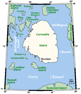
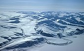
Cornwallis Island is one of the Queen Elizabeth Islands, part of the Arctic Archipelago, in the Qikiqtaaluk Region of Nunavut in the Canadian Arctic. It lies to the west of Devon Island, the largest uninhabited island in the world, and at its greatest length is about 113 km (70 mi). At 6,995 km2 (2,701 sq mi) in size, it is the 96th largest island in the world, and Canada's 21st largest island. Cornwallis Island is separated by the Wellington Channel from Devon Island, and by the Parry Channel from Somerset Island to the south. Northwest of Cornwallis Island lies Little Cornwallis Island, the biggest of a group of small islands at the north end of McDougall Sound, which separates Cornwallis Island from nearby Bathurst Island.

<span class="mw-page-title-main">Kitikmeot Region</span> Region in Nunavut, Canada

Kitikmeot Region is an administrative region of Nunavut, Canada. It consists of the southern and eastern parts of Victoria Island with the adjacent part of the mainland as far as the Boothia Peninsula, together with King William Island and the southern portion of Prince of Wales Island. The regional centre is Cambridge Bay.

<span class="mw-page-title-main">King William Island</span> Island in Nunavut, Canada

King William Island is an island in the Kitikmeot Region of Nunavut, which is part of the Arctic Archipelago. In area it is between 12,516 km2 (4,832 sq mi) and 13,111 km2 (5,062 sq mi) making it the 61st-largest island in the world and Canada's 15th-largest island. Its population, as of the 2021 census, was 1,349, all of whom live in the island's only community, Gjoa Haven.

<span class="mw-page-title-main">Hay River, Northwest Territories</span> Town in Northwest Territories, Canada

Hay River, known as "the Hub of the North", is a town in the Northwest Territories, Canada, located on the south shore of Great Slave Lake, at the mouth of the Hay River. The town is separated into two sections, a new town and an old town with the Hay River/Merlyn Carter Airport between them. The town is in the South Slave Region, and along with Fort Smith, the town is home to one of the two regional offices.

<span class="mw-page-title-main">Arviat</span> Hamlet in Nunavut, Canada

Arviat is a predominantly Inuit hamlet located on the western shore of Hudson Bay in the Kivalliq Region of Nunavut, Canada. Arviat is derived from the Inuktitut word arviq meaning "Bowhead whale". Earlier in history, its name was Tikirajualaaq, and Ittaliurvik,.

<span class="mw-page-title-main">Resolute, Nunavut</span> Place in Nunavut, Canada

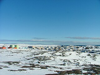
Resolute or Resolute Bay is an Inuit hamlet on Cornwallis Island in Nunavut, Canada. It is situated at the northern end of Resolute Bay and the Northwest Passage and is part of the Qikiqtaaluk Region.

<span class="mw-page-title-main">Kinngait</span> Hamlet in Nunavut, Canada

Kinngait, known as Cape Dorset until 27 February 2020, is an Inuit hamlet located on Dorset Island near Foxe Peninsula at the southern tip of Baffin Island in the Qikiqtaaluk Region of Nunavut, Canada.

<span class="mw-page-title-main">Kugluktuk</span> Hamlet in Nunavut, Canada

Kugluktuk, formerly known as Coppermine until 1 January 1996, is a hamlet located at the mouth of the Coppermine River in the Kitikmeot Region of Nunavut, Canada, on Coronation Gulf, southwest of Victoria Island. It is the westernmost community in Nunavut, near the border with the Northwest Territories.

<span class="mw-page-title-main">Naujaat</span> Place in Nunavut, Canada

Naujaat, Anglicised and officially known until 2 July 2015 as Repulse Bay, is an Inuit hamlet situated on the Arctic Circle. It is located on the shores of Hudson Bay, at the south end of the Melville Peninsula, in the Kivalliq Region of Nunavut, Canada.

<span class="mw-page-title-main">Taloyoak</span> Hamlet in Nunavut, Canada

Taloyoak or Talurjuaq, formerly known as Spence Bay until 1 July 1992, although the body of water on which it is situated continues to be known as Spence Bay — same as the body of water on which Iqaluit is situated continues to be known as Frobisher Bay — is located on the Boothia Peninsula, in the Kitikmeot Region of Nunavut, Canada. The community is served only by air and by annual supply sealift. Taloyoak, the northernmost community in mainland Canada, in Inuktitut means "large blind", referring to a stone caribou blind or a screen used for caribou hunting. The community is situated 460 km (290 mi) east of the regional centre of Cambridge Bay, 1,224 km (761 mi) northeast of Yellowknife, Northwest Territories.

<span class="mw-page-title-main">Nunavut</span> Territory of Canada

Nunavut is the largest and northernmost territory of Canada. It was separated officially from the Northwest Territories on April 1, 1999, via the Nunavut Act and the Nunavut Land Claims Agreement Act, which provided this territory to the Inuit for independent government. The boundaries had been drawn in 1993. The creation of Nunavut resulted in the first major change to Canada's political map in half a century since the province of Newfoundland was admitted in 1949.

<span class="mw-page-title-main">Apex, Iqaluit</span>

Apex is a small community in Iqaluit located on Baffin Island in Nunavut, Canada. It is about 5 km (3.1 mi) southeast of Iqaluit on a small peninsula separating Koojesse (Kuujussi) Inlet from Tarr Inlet. Historically Apex was the place where most Inuit lived when Iqaluit was a military site and off-limits to anyone not working at the base. The community is accessed by bridge or causeway, and bordered by a local creek (kuujuusi) and waterfall (kugluktuk). Located here are the women's shelter, a church, Nanook Elementary School, and a bed-and-breakfast, along with housing for about 60 families.

References

  1. 1 2 "Alert". Canadian Climate Normals 1981-2010 Station Data. Environment and Climate Change Canada. 31 October 2011. Climate ID: 2400300. Retrieved 13 January 2016.
  2. "Baker Lake A". Canadian Climate Normals 1981–2010. Environment Canada. 25 September 2013. Climate ID: 2300500. Retrieved 19 October 2020.
  3. 1 2 "Cambridge Bay A *". Canadian Climate Normals 1981–2010. Environment and Climate Change Canada. Climate ID: 2400600. Archived from the original on 30 September 2023. Retrieved 30 April 2014.
  4. 1 2 "Eureka A". Canadian Climate Normals 1981–2010. Environment and Climate Change Canada . Retrieved 12 May 2016.
  5. 1 2 "Iqaluit A". Canadian Climate Normals 1981–2010. Environment and Climate Change Canada. 31 October 2011. Climate ID: 2402590. Archived from the original on 16 May 2017. Retrieved 24 February 2014.
  6. 1 2 "Kugluktuk A *". Canadian Climate Normals 1981–2010. Environment and Climate Change Canada. Climate ID: 2300902. Retrieved 30 April 2014.
  7. 1 2 "Rankin Inlet A". Canadian Climate Normals 1981–2010. Environment and Climate Change Canada. Climate ID: 2303401. Retrieved 19 October 2020.
  8. "Daily Data Report for October 2006". Canadian Climate Data. Environment and Climate Change Canada. 31 October 2011. Retrieved 12 May 2016.
  9. "Daily Data Report for June 2009". Canadian Climate Data. Environment and Climate Change Canada. 31 October 2011. Retrieved 12 May 2016.
  10. "Daily Data Report for May 2012". Canadian Climate Data. Environment and Climate Change Canada. 31 October 2011. Retrieved 12 May 2016.
  11. "Daily Data Report for July 2019". Canadian Climate Data. Environment and Climate Change Canada. 31 October 2011. Retrieved 17 July 2019.
  12. "Daily Data Report for June 2020 - Climate - Environment and Climate Change Canada". climate.weather.gc.ca. Environment and Climate Change Canada. 31 October 2011. Retrieved 11 July 2020.
  13. "Iqaluit (Composite Station Threads)". Canadian Climate Normals 1991-2020 Data. Environment and Climate Change Canada. Archived from the original on 29 September 2023. Retrieved 29 September 2023.
  14. "Iqaluit, Canada - Detailed climate information and monthly weather forecast". Weather Atlas. Yu Media Group. Retrieved 6 July 2019.
  15. "Cambridge Bay (Composite Station Threads)". Canadian Climate Normals 1991-2020 Data. Environment and Climate Change Canada. Archived from the original on 30 September 2023. Retrieved 30 September 2023.
  16. "Daily Data Report for August 2011". Canadian Climate Data. Environment and Climate Change Canada. Retrieved 12 May 2016.
  17. "Daily Data Report for August 2013". Canadian Climate Data. Environment and Climate Change Canada. Retrieved 12 May 2016.
  18. "Hourly Data Report for February 04, 2022". Canadian Climate Data. Environment and Climate Change Canada. Retrieved 11 February 2022.
  19. "Canadian Climate Normals 1991-2020 Data". Canadian Climate Normals. Environment and Climate Change Canada. Retrieved 1 October 2023.
  20. "Kugluktuk (Composite Station Threads)". Canadian Climate Normals 1991-2020 Data. Environment and Climate Change Canada. Archived from the original on 21 December 2023. Retrieved 21 December 2023.
  21. "Canadian Climate Normals 1951–1980 Volume 2: Temperature" (PDF). Environment Canada. Archived from the original (PDF) on 9 August 2023. Retrieved 24 October 2020.
  22. "Canadian Climate Normals 1951–1980 Volume 8: Atmospheric, Pressure, Temperature and Humidity" (PDF). Environment Canada. Archived from the original (PDF) on 9 August 2023. Retrieved 11 August 2023.
  23. "EIA". Archived from the original on 7 May 2013. Retrieved 4 May 2013.
  24. "Aboriginal peoples in Canada: Focus on Inuit in Nunavut" (PDF). Statistics Canada. 15 January 2008. Archived from the original (PDF) on 5 March 2016. Retrieved 4 May 2013.

60°N102°W / 60°N 102°W / 60; -102