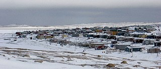
Sanikiluaq is a municipality and Inuit community located on the north coast of Flaherty Island in Hudson Bay, on the Belcher Islands. Despite being geographically much closer to the shores of Ontario and Quebec, the community and the Belcher Islands lie within the Qikiqtaaluk Region of Nunavut, Canada.
Ovayok Territorial Park is a park situated 15 km (9.3 mi) east of Cambridge Bay, in the Kitikmeot Region, Nunavut, Canada. The park is relatively small and covers an area of approximately 16 km2 (6.2 sq mi). The park can be accessed by vehicle from the community as a gravel road runs directly to it.

Baker Lake is a territorial electoral district (riding) for the Legislative Assembly of Nunavut, Canada. The riding consists of the community of Baker Lake. The current Member of the Legislative Assembly is Simeon Mikkungwak.
Chopawamsic Creek is a 6.8-mile-long (10.9 km) tributary of the Potomac River in Prince William and Stafford counties, Virginia. Chopawamsic Creek is formed by the confluence of the North and South Branches of Chopawamsic Creek and empties into the Potomac River south of Quantico at the Marine Corps Base Quantico's Air Station. Breckenridge Reservoir lies at the stream's confluence with the North and South Branches. Along with its North Branch, Chopawamsic Creek forms part of the boundary between Prince William and Stafford counties. The North Branch flows through part of the Chopawamsic Backcountry Area in Prince William Forest Park.
Katannilik Territorial Park Reserve is a territorial park in the Qikiqtaaluk Region of Nunavut, Canada. It was established in 1993 and has an area of 1,262 km2 (487 sq mi). The Soper River, part of the Canadian Heritage Rivers System, flows through the park.
Iqalugaarjuup Nunanga Territorial Park is a park located 8–10 km (5.0–6.2 mi) northwest of Rankin Inlet, Nunavut, Canada. The park is situated in the valley which straddles the Meliadine River. Access is available by foot or vehicle along a gravel road from the community of Rankin Inlet directly to the south side of the park.
The Northwest Passage Territorial Park is located at Gjoa Haven, on King William Island, Kitikmeot Region, Nunavut, Canada. The park consists of six areas that show in part the history of the exploration of the Northwest Passage and the first successful passage by Roald Amundsen in the Gjøa.
Pomonkey Creek is a 1.8-mile-long (2.9 km) tidal tributary of the Potomac River, near Bryans Road, Maryland. It is named for the Pamunkey tribe of Native Americans that lived in the area.
Cisów is a village in the administrative district of Gmina Sztabin, within Augustów County, Podlaskie Voivodeship, in north-eastern Poland. It lies approximately 8 kilometres (5 mi) north of Sztabin, 15 km (9 mi) south-east of Augustów, and 71 km (44 mi) north of the regional capital Białystok.
Olszewice is a village in the administrative district of Gmina Sławno, within Opoczno County, Łódź Voivodeship, in central Poland. Its coordinates are 52 12' 00 N and 21 49' 00 W. Its neighbouring districts are Chroscice, Falbogi, Gojsc, Grodzisk, Kaluszyn, Kluki, Kruki, Mroczki, Mrozy, Rudka, Rudniki, Ryczolek, Szymony, Wasy, Wity.
Jarocin is a village in Nisko County, Subcarpathian Voivodeship, in south-eastern Poland. It is the seat of the gmina called Gmina Jarocin. It lies approximately 14 kilometres (9 mi) east of Nisko and 64 km (40 mi) north of the regional capital Rzeszów.
Caribou River Provincial Wilderness Park is a provincial park in extreme north-central Manitoba, Canada. It is the northernmost provincial park in Manitoba, and borders the southern Nunavut border.
Biały Dwór is a village in the administrative district of Gmina Lubowidz, within Żuromin County, Masovian Voivodeship, in east-central Poland.
Tarnowiec is a village in the administrative district of Gmina Tarnówka, within Złotów County, Greater Poland Voivodeship, in west-central Poland. It lies approximately 4 kilometres (2 mi) south-east of Tarnówka, 11 km (7 mi) south-west of Złotów, and 103 km (64 mi) north of the regional capital Poznań.
Terra Roxa, Paraná is a municipality in the state of Paraná in the Southern Region of Brazil.
Padlei is a former community in the Kivalliq Region of Nunavut, Canada. It is located on the mainland on the north shore of Kinga (Kingarvalik) Lake at the juncture of the Maguse River. Whale Cove is to the east, while the Henik Lakes are to the southwest.

South Carlsbad State Beach is a public beach located in Carlsbad, California.

Kekerten Territorial Park is a park on Kekerten Island, about 50 km (31 mi) south of Pangnirtung, in the Qikiqtaaluk Region of Nunavut, Canada.
Qaummaarviit Territorial Park is located 12 km (7.5 mi) west of Iqaluit in the Qikiqtaaluk Region of Nunavut, Canada. Situated on a small island near Peterhead Inlet, it is thought that the island was inhabited by the Thule people in the early part of the 13th century.
Getchell is an unincorporated community in Snohomish County, in the U.S. state of Washington.