East Bay Migratory Bird Sanctuary

Last updated
East Bay (Qaqsauqtuuq) Migratory Bird Sanctuary
Canada Nunavut location map-lambert proj3.svg
Red pog.svg
Location Southampton Island, Kivalliq, Nunavut, Canada
Nearest town Coral Harbour [1]
Coordinates 64°N82°W / 64°N 82°W / 64; -82 [2]
Area112,811 ha (1,128.11 km2; 435.57 sq mi) [1]
Established1959

The East Bay (Qaqsauqtuuq) Migratory Bird Sanctuary, Qaqsauqtuuq Migratory Bird Sanctuary, [1] or Refuge d'oiseaux de la baie Est [4] is a migratory bird sanctuary in the Kivalliq Region, Nunavut, Canada. It is located in East Bay, an arm of Hudson Bay, in southeast Southampton Island. The nearest community is Coral Harbour, 35 km (22 mi) to the west. [1]

Contents

It is one of two bird sanctuaries on the island, the other being the Harry Gibbons Migratory Bird Sanctuary, situated 193 km (120 mi) to the southwest. [5]

Established 1 January 1959, and consisting of 112,811 ha (1,128.11 km2; 435.57 sq mi) [1] it is rated Category IV by the International Union for Conservation of Nature. Of its 1,124 km2 (434 sq mi) in overall size, 286 km2 (110 sq mi) is a marine area with marine, intertidal, and subtidal components. [6]

Climate

Closeup of Southampton Island SouthamptonIslandCloseup.png
Closeup of Southampton Island

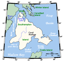
Southampton Island has a severe subarctic climate (Köppen Dfc) which transitions into a tundra climate (ET). Like almost all of Nunavut, Southampton Island is entirely above the tree line. Coral Harbour has never gone above freezing in January, February and March (although the latter has recorded 0.0 °C (32.0 °F). Due to the frozen nature of Hudson Bay, there is a severe seasonal lag until June, especially compared to more continental areas such as Fairbanks despite much sunshine and perpetual twilight at night. Due to the drop of solar strength and the absence of warm water even in summer, temperatures still drop off very fast as September approaches. Cold extremes are severe, but in line with many areas even farther south in Canada's interior.

Climate data for Coral Harbour (Coral Harbour Airport)
WMO ID: 71915; coordinates 64°11′36″N83°21′34″W / 64.19333°N 83.35944°W / 64.19333; -83.35944 (Cambridge Bay Airport) ; elevation: 62.2 m (204 ft); 1981–2010 normals
MonthJanFebMarAprMayJunJulAugSepOctNovDecYear
Record high humidex −0.6−1.9−0.54.48.922.832.830.119.97.63.73.232.8
Record high °C (°F)−0.6
(30.9)
−1.1
(30.0)
0.0
(32.0)
7.2
(45.0)
9.4
(48.9)
23.3
(73.9)
28.0
(82.4)
26.1
(79.0)
18.5
(65.3)
7.6
(45.7)
4.0
(39.2)
3.4
(38.1)
28.0
(82.4)
Mean daily maximum °C (°F)−25.5
(−13.9)
−25.5
(−13.9)
−20.4
(−4.7)
−10.9
(12.4)
−2.9
(26.8)
6.4
(43.5)
14.7
(58.5)
11.7
(53.1)
4.6
(40.3)
−3.0
(26.6)
−11.9
(10.6)
−20.1
(−4.2)
−6.9
(19.6)
Daily mean °C (°F)−29.6
(−21.3)
−29.7
(−21.5)
−25.2
(−13.4)
−16.1
(3.0)
−6.7
(19.9)
3.1
(37.6)
10.0
(50.0)
7.7
(45.9)
1.7
(35.1)
−6.1
(21.0)
−16.1
(3.0)
−24.4
(−11.9)
−11.0
(12.2)
Mean daily minimum °C (°F)−33.7
(−28.7)
−33.9
(−29.0)
−29.9
(−21.8)
−21.1
(−6.0)
−10.5
(13.1)
−0.3
(31.5)
5.3
(41.5)
3.6
(38.5)
−1.2
(29.8)
−9.1
(15.6)
−20.3
(−4.5)
−28.6
(−19.5)
−15.0
(5.0)
Record low °C (°F)−52.8
(−63.0)
−51.4
(−60.5)
−49.4
(−56.9)
−39.4
(−38.9)
−31.1
(−24.0)
−15.6
(3.9)
−1.1
(30.0)
−3.3
(26.1)
−17.2
(1.0)
−34.4
(−29.9)
−40.6
(−41.1)
−48.9
(−56.0)
−52.8
(−63.0)
Record low wind chill −69.5−69.3−64.3−55.1−39.7−23.2−8.2−11.8−23.7−43.7−54.8−64.2−69.5
Average precipitation mm (inches)9.5
(0.37)
7.0
(0.28)
11.2
(0.44)
18.2
(0.72)
19.0
(0.75)
27.6
(1.09)
34.1
(1.34)
59.4
(2.34)
45.4
(1.79)
33.8
(1.33)
22.9
(0.90)
14.8
(0.58)
302.9
(11.93)
Average rainfall mm (inches)0.0
(0.0)
0.0
(0.0)
0.0
(0.0)
0.4
(0.02)
4.3
(0.17)
20.8
(0.82)
34.1
(1.34)
58.9
(2.32)
36.7
(1.44)
7.2
(0.28)
0.5
(0.02)
0.0
(0.0)
163.0
(6.42)
Average snowfall cm (inches)9.6
(3.8)
7.1
(2.8)
11.3
(4.4)
18.2
(7.2)
14.9
(5.9)
6.9
(2.7)
0.0
(0.0)
0.6
(0.2)
8.6
(3.4)
26.7
(10.5)
22.9
(9.0)
14.8
(5.8)
141.6
(55.7)
Average precipitation days (≥ 0.2 mm)8.56.79.09.510.49.69.612.611.214.613.010.4125.1
Average rainy days (≥ 0.2 mm)0.00.00.00.21.87.29.612.58.23.60.60.143.8
Average snowy days (≥ 0.2 cm)8.66.69.09.59.43.30.00.34.313.112.910.487.3
Average relative humidity (%)64.964.267.573.880.373.963.168.975.684.877.669.772.0
Mean monthly sunshine hours 37.9112.1187.4240.2239.9262.2312.3220.4109.870.847.918.81,859.7
Percent possible sunshine 22.447.051.653.242.041.951.243.327.923.324.313.936.8
Source: Environment and Climate Change Canada Canadian Climate Normals 1981–2010 [7]

Flora

The sanctuary's habitat consists of three main types, water, unvegetated land, and moist or wet vegetated tundra. [8] This can be further broken down as dry heath, gravel ridge, intertidal zone, moss carpet, scrub willow, and sedge meadow. [9]

A 1986 list of plants in the sanctuary found over 100 species of algae, fungi, lichens, bryophytes, and vascular plants. [10]

Plants found in the sanctuary include: [10]

Fauna

Bird species

Birds listed by the Committee on the Status of Endangered Wildlife in Canada (COSEWIC) or the Species at Risk Act (SARA) are noted as to their status. [11] Bird species include: [1] [12] [13]

Mammals

Mammals in the area are mainly Arctic fox (Alopex lagopus), Arctic hare (Lepus arcticus), brown (Lemmus sibiricus), and collared lemmings (Dicrostonyx groenlandicus). Barren-ground caribou (Rangifer tarandus) were reintroduced from Coats Island in 1967. Scb Wolves (Canis lupus), red foxes (Vulpes vulpes), and wolverines (Gulo gulo Sc ) are occasionally sighted. [14]

Marine mammals include Atlantic walrus (Odobenus rosmarus rosmarus Scb ), bearded seal (Erignathus barbatus), beluga whale (Delphinapterus leucas Scb ), bowhead whale (Balaena mysticetus Scb ), harbor seal (Phoca vitulina), harp seal (Pagophilus groenlandicus), narwhal (Monodon monoceros Scb ), polar bear (Ursus maritimus), ringed seal (Pusa hispida Scb ), walrus (Odobenus rosmarus). [10]

Other designations

East Bay/Native Bay is a Canadian Important Bird Area (#NU023) and a Key Migratory Bird Terrestrial Habitat (NU Site 44). [13]

Notes

  1. 1 2 3 4 5 6 ECCC 2024.
  2. "East Bay Migratory Bird Sanctuary". Geographical Names Data Base . Natural Resources Canada. 23 May 2024.
  3. "East Bay Migratory Bird Sanctuary". Geographical Names Data Base . Natural Resources Canada. 23 May 2024.
  4. "Refuge d'oiseaux de la baie Est". Geographical Names Data Base . Natural Resources Canada. 24 May 2024.
  5. "Point-to-point distance East Bay Bird Sanctuary – Harry Gibbons Bird Sanctuary". 16 February 2021. Retrieved 23 May 2024.
  6. ECCC 2020, p. Table 1: Qaqsauqtuuq Migratory Bird Sanctuary Summary Information.
  7. "Coral Harbour A". Canadian Climate Normals 1981–2010. Environment and Climate Change Canada. Climate ID: 2301000. Retrieved 2019-01-24.
  8. ECCC 2020, p. 11.
  9. Pickavance, J.R. (September 2006). "The Spiders of East Bay, Southampton Island, Nunavut, Canada". Arctic. 59 (3): 278. doi:10.14430/arctic313.
  10. 1 2 3 ECCC 2020, p. 17.
  11. 1 2 3 ECCC 2020, p. 18.
  12. ECCC 2020, pp. 10–16, 18.
  13. 1 2 "East Bay/Native Bay". bsc-eoc.org. Archived from the original on 2011-06-12. Retrieved 2009-05-05.
  14. ECCC 2020, p. 16.
  15. 1 2 3 ECCC 2020, pp. 18, 19.

Related Research Articles

<span class="mw-page-title-main">Baffin Island</span> Largest Arctic island in Nunavut, Canada

Baffin Island, in the Canadian territory of Nunavut, is the largest island in Canada, the second largest island in the Americas, and the fifth-largest island in the world. Its area is 507,451 km2 (195,928 sq mi) with a population density of 0.03/km2; the population was 13,039 according to the 2021 Canadian census; and it is located at 68°N70°W. It also contains the city of Iqaluit, which is the capital of Nunavut.

<span class="mw-page-title-main">Ukkusiksalik National Park</span> National park in Nunavut, Canada

Ukkusiksalik National Park is a national park in Nunavut, Canada. It covers 20,885 km2 (8,064 sq mi) of tundra and coastal mudflats south of the Arctic Circle and the hamlet of Naujaat, from Hudson Bay's Roes Welcome Sound towards the western Barrenlands and the source of Brown River. The park surrounds Wager Bay, a 100 km (62 mi)-long inlet on the Hudson Bay. Although the smallest of Nunavut's four national parks, it is the sixth largest in Canada. Its name relates to steatite found there: Ukkusiksalik means "where there is material for the stone pot".

<span class="mw-page-title-main">Akimiski Island</span> Island in southern Hudson Bay

Akimiski Island is the largest island in James Bay, Canada, which is part of the Qikiqtaaluk Region of the territory of Nunavut. It has an area of 3,001 km2 (1,159 sq mi), making it the 163rd largest island in the world, and Canada's 29th largest island. Akimiski Island is 19 km (12 mi) from the province of Ontario. From the western side of the island, the Ontario coastline is visible.

<span class="mw-page-title-main">Southampton Island</span> Island in north Hudson Bay in Nunavut, Canada

Southampton Island is a large island at the entrance to Hudson Bay at Foxe Basin. One of the larger members of the Arctic Archipelago, Southampton Island is part of the Kivalliq Region in Nunavut, Canada. The area of the island is stated as 41,214 km2 (15,913 sq mi) by Statistics Canada. It is the 34th largest island in the world and Canada's ninth largest island. The only settlement on Southampton Island is Coral Harbour, called Salliq in Inuktitut.

<span class="mw-page-title-main">Birds of North American boreal forests</span>

The boreal forest or taiga of the North American continent stretches through a majority of Canada and most of central Alaska, extending spottily into the beginning of the Rocky Mountain range in Northern Montana and into New England and the Adirondack Mountains of New York. This habitat extends as far north as the tree line and discontinues in mixed deciduous-coniferous forests to the south. The "taiga", as it is called there, of Eurasia occupies a similar range on those continents. Throughout the Northern Hemisphere, the boreal forest covers 2.3 million square miles, a larger area than the remaining Brazilian Amazon rain forest. Although it is largely forest, the boreal forests include a network of lakes, river valleys, wetlands, peat lands and semi-open tundra.

This is a list of the fauna of Finland. Finland borders Sweden to the west, Russia to the east, and Norway to the north, while Estonia lies to its south across the Gulf of Finland, allowing an ecological mix. Finland contains many species of mammals, birds, and fish, but only a few reptiles and amphibians. This article discusses all the vertebrate animals which can be found on Finland itself, not the oceans.

<span class="mw-page-title-main">Pitsiulartok</span> Island in Nunavut, Canada

Pitsiulartok or Pituilaktok is a small, uninhabited island located at 63°15'N, 90°33'W in Hudson Bay, about 13 km from the community of Chesterfield Inlet, Nunavut, Canada. The narrow island is about 3.5 km in length and barely 1 km wide at its widest point. Traditionally it was a walrus-hunting ground for the local Inuit, and a landmark for southern whalers. It is part of a loose chain of small islands running along the coast, including Sakpik Island and Promise Island.

The Twin Islands are similarly shaped Arctic islands in the Qikiqtaaluk Region of Nunavut, Canada. They are located in central James Bay, 56 km (35 mi) north east of Akimiski Island, and 58 km (36 mi) west of Quebec. The group includes North Twin and South Twin islands.

<span class="mw-page-title-main">Bluenose Lake</span> Lake in Nunavut, Canada

Bluenose Lake is a lake in Kitikmeot Region, Nunavut, Canada. It is located north of the Arctic Circle within the large, shallow basin of the Melville Hills. It is approximately 33 mi (53 km) long, 12 mi (19 km) wide, and is situated at 1,800 ft (550 m) above sea level. The Croker River flows north from Bluenose Lake to the Arctic Ocean, entering at Dolphin and Union Strait.

The Boas is a river on Southampton Island in Nunavut, Canada. The river rises at 64°49′58″N084°23′34″W and its mouth is located at the Bay of Gods Mercy. Proceeding inland, the river becomes braided and is about 5 kilometres (3.1 mi) wide.

East Bay is a waterway in the Kivalliq Region, Nunavut, Canada. It is located in Hudson Bay off eastern Southampton Island. Caribou Island lies to the north of the bay's mouth. The nearest community is Coral Harbour, 35 km (22 mi) to the west.

Native Bay is a waterway in the Kivalliq Region, Nunavut, Canada. It is located in Hudson Bay off western Southampton Island. The Bell Peninsula lies to the southeast. Native Point is located at the bay's southern tip. East Bay is 20 km (12 mi) to the east and Coral Harbour is 36 km (22 mi) to the north northwest.

Seymour Island is an uninhabited island in the Qikiqtaaluk Region of northern Canada's territory of Nunavut. A member of the Berkeley Islands group, it is located approximately 30 mi (48 km) north of northern Bathurst Island. Between Seymour Island and Bathurst Island lies Helena Island. Penny Strait lies about 90 km (56 mi) to the east where open water polynyas occur.

<span class="mw-page-title-main">Middle Arctic tundra</span> Tundra ecoregion of Canada

The Canadian Middle Arctic Tundra ecoregion covers a broad stretch of northern Canada - the southern islands of the Arctic Archipelago, plus the northern mainland of Nunavut and, across Hudson Bay to the east, a portion of northern Quebec. This is the coldest and driest ecoregion in Canada, and can be referred to as a 'polar desert'. It is an important region for breeding and migratory birds, and supports 80% of the world's muskox.

References