Geography | |
---|---|
Location | Cumberland Sound |
Coordinates | 65°42′N065°48′W / 65.700°N 65.800°W Coordinates: 65°42′N065°48′W / 65.700°N 65.800°W |
Archipelago | Arctic Archipelago |
Administration | |
Canada | |
Nunavut | Nunavut |
Region | Qikiqtaaluk |
Demographics | |
Population | Uninhabited |
Kekerten Island is an uninhabited island in the Qikiqtaaluk Region of Nunavut, Canada. Southernmost of the Kikastan Islands, it is located in the Cumberland Sound, off Baffin Island's Cumberland Peninsula. Akulagok Island forms Kekerten Harbour with the island. Tuapait Island lies to the north. Beacon Island, Kekertukdjuak Island, Miliakdjuin Island, Tesseralik Island, and Ugpitimik Island are in the vicinity. [1]
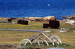
Kekerten Territorial Park is located on the island. [2]
Scottish whalers had been fishing in the Cumberland Sound since the early 19th century and with the arrival of the American whalers in the 1850s winter stations were established. The Aberdeen whaler, Cpt. William Penny spent several winters around 1883–84 at Kekerten. The anthropologist Franz Boas similarly lived at the Kekerten settlement while studying Baffin Island for 13 months starting in August 1883. [3] In 1915, Kekerten was purchased by Robert Kinnes & Co. and operated as a trading post until it was sold to the Hudson's Bay Company in 1923. With the establishment of the main HBC post at Pangnirtung, Kekerten was abandoned in 1925.
The Adlet are a race of creatures in the Inuit mythology of Greenland, as well as the Labrador and Hudson Bay coasts. While the word refers to inland native American tribes, it also denotes a humanoid dog-legged tribe. The lower part of the body of the canine Adlet is like that of a dog and their upper part is like a man's. All Adlet run quickly, and their encounters with men usually end with man as the victor.
Baffin Bay, located between Baffin Island and the west coast of Greenland, is defined by the International Hydrographic Organization as a marginal sea of the Arctic Ocean. It is sometimes considered a sea of the North Atlantic Ocean. It is connected to the Atlantic via Davis Strait and the Labrador Sea. The narrower Nares Strait connects Baffin Bay with the Arctic Ocean. The bay is not navigable most of the year because of the ice cover and high density of floating ice and icebergs in the open areas. However, a polynya of about 80,000 km2 (31,000 sq mi), known as the North Water, opens in summer on the north near Smith Sound. Most of the aquatic life of the bay is concentrated near that region.
The Qikiqtaaluk Region, Qikiqtani Region or Baffin Region is the easternmost, northernmost, and southernmost administrative region of Nunavut, Canada. Qikiqtaaluk is the traditional Inuktitut name for Baffin Island. Although the Qikiqtaaluk Region is the most commonly used name in official contexts, several notable public organizations, including Statistics Canada prefer the older term Baffin Region.
Sirmilik National Park is a national park located in Qikiqtaaluk, Nunavut, Canada, established in 1999. Situated within the Arctic Cordillera, the park is composed of three areas: most of Bylot Island with the exception for a few areas that are Inuit-owned lands, Oliver Sound, and Baffin Island's Borden Peninsula. Much of the park is bordered by water.
Cumberland Peninsula is a peninsula in the southeastern part of Baffin Island in Nunavut, Canada. It is located between 64°56' and 67°57' north latitude, and 61°56' to 68° west longitude. The Arctic Circle crosses the peninsula, with the Labrador Sea to the southeast, and the Davis Strait to the east, which lies between the peninsula and Greenland. The Cumberland Sound lies to the southwest, separating the Cumberland Peninsula from the Hall Peninsula, which is also part of Baffin Island.
Cumberland Sound is an Arctic waterway in Qikiqtaaluk Region, Nunavut, Canada. It is a western arm of the Labrador Sea located between Baffin Island's Hall Peninsula and the Cumberland Peninsula. It is approximately 250 km (160 mi) long and 80 km (50 mi) wide. Other names are Cumberland Straits,Hogarth Sound, and Northumberland Inlet. Old Norse is ᚠᛁᛋᚦᚱᛁ ᚢᛒᚢᚴᚦᛁᛦ, fisþri ubukþiR.
The Cumberland Sound belugas are a distinct population of belugas residing in the Cumberland Sound region of the Labrador Sea off the coast of Nunavut, Canada Individuals of this population reside in the sound year-round, congregating in its extreme north exclusively at Clearwater Fjord during the summer for calving. The Cumberland Sound beluga population is considered fairly isolated and genetically distinct from other beluga populations, with a notable number of haplotypes and microsatellite loci not found elsewhere.
Cape Fullerton is a cape and peninsula in the Kivalliq Region of Nunavut, Canada located on the northwest shores of Hudson Bay on Roes Welcome Sound and includes Fullerton Harbour. Today it is part of Ukkusiksalik National Park. Although Cape Fullerton was traditionally home to migrant Inuit including the Aivilingmiut and the Qaernermiut, today the nearest permanently populated settlement is Chesterfield Inlet, roughly 100 km (62 mi) to the southwest.
The Penny Ice Cap, formerly Penny Icecap, is a 6,000 km2 (2,300 sq mi) ice cap in Auyuittuq National Park of Baffin Island, Nunavut, Canada. It forms a 2,000 m (6,562 ft) high barrier on the Cumberland Peninsula, an area of deep fjords and glaciated valleys. It is a remnant of the last ice age. During the mid-1990s, Canadian researchers studied the glacier's patterns of freezing and thawing over centuries by drilling ice core samples.
Captain William Penny (1809–1892) was a Scottish shipmaster, whaler and Arctic explorer. He undertook the first maritime search for the ships of Sir John Franklin. In 1840, Penny established the first whaling station in the Cumberland Sound area on Kekerten Island.
Nuvujen Island is an uninhabited Baffin Island offshore island located in the Arctic Archipelago in Nunavut's Qikiqtaaluk Region. It lies on the western shore of Cumberland Sound, between Brown Inlet to the northwest and Robert Peel Inlet to the southeast. Aupaluktut Island lies to its south.
Nimigen Island is an uninhabited Baffin Island offshore island located in the Arctic Archipelago in Nunavut's Qikiqtaaluk Region. It lies in Cumberland Sound, approximately 10.5 km (6.5 mi) east of Robert Peel Inlet To its east is Utsusivik Island; south is Chidliak Bay.
Wareham Island is an uninhabited island in the Qikiqtaaluk Region of Nunavut, Canada. It is located in the Cumberland Sound, off Baffin Island's Cumberland Peninsula, southwest of the mouth of Kumlien Fiord. Akulagok Island, Kekerten Island, Kekertukdjuak Island, Miliakdjuin Island, Tesseralik Island, and Tuapait Island are in the vicinity.
Akulagok Island is an uninhabited island in the Qikiqtaaluk Region of Nunavut, Canada. It belongs to the Kikastan Islands, located in the Cumberland Sound, off Baffin Island's Cumberland Peninsula. On its south side, Kekerten Harbour lies between Akulagok and Kekerten Island, while to the north lies Tuapait Island. Aupaluktok Island, Beacon Island, Kekertukdjuak Island, Miliakdjuin Island, Tesseralik Island, and Ugpitimik Island are in the vicinity.
Kekertukdjuak Island formerly Kekertuk Island is an uninhabited island in the Qikiqtaaluk Region of Nunavut, Canada. It is located where Kingnait Fiord joins the Cumberland Sound, off Baffin Island's Cumberland Peninsula. The Kikastan Islands lie to its southwest. Beacon Island, Miliakdjuin Island, Tesseralik Island, and Ugpitimik Island are in the vicinity.
Miliakdjuin Island is an uninhabited island in the Qikiqtaaluk Region of Nunavut, Canada. It is located southeast of the Kikastan Islands in the Cumberland Sound, off Baffin Island's Cumberland Peninsula. Akulagok Island, Kekerten Island, Kekertukdjuak Island, Tesseralik Island, Tuapait Island, and Wareham Island are in the vicinity.
Tuapait Island is an uninhabited island in the Qikiqtaaluk Region of Nunavut, Canada. It is one of the Kikastan Islands, located in the Cumberland Sound, off Baffin Island's Cumberland Peninsula. To its south lie Akulagok Island and Kekerten Island. Aupaluktok Island, Beacon Island, Kekertukdjuak Island, Miliakdjuin Island, Tesseralik Island, and Ugpitimik Island are in the vicinity.
Upajjana (ᐅᐸᔾᔭᓇ) formerly Beacon Island is an uninhabited island in the Qikiqtaaluk Region of Nunavut, Canada. It lies in the Cumberland Sound, at the mouth of the Pangnirtung Fiord, near Pangnirtung off Baffin Island's Cumberland Peninsula. Akulagok Island, Aupaluktok Island, Imigen Island, Kekerten Island, Kekertukdjuak Island, Tesseralik Island, Tuapait Island, and Ugpitimik Island are in the vicinity.
Kekerten Territorial Park is a park on Kekerten Island, about 50 km (31 mi) south of Pangnirtung, in the Qikiqtaaluk Region of Nunavut, Canada.
Broughton Island is a 127.6 km2 (49.3 sq mi) island in the Arctic Archipelago.