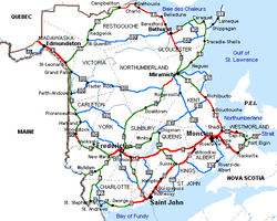
Geography of New Brunswick

Last updated

New Brunswick, Canada.svg
Road map of New Brunswick. New Brunswick road map.png
Road map of New Brunswick.

New Brunswick (French : Nouveau-Brunswick) is one of Canada's three Maritime provinces. While New Brunswick is one of Canada's Maritime Provinces, it differs from its neighbours both ethnoculturally and physiographically. Both Nova Scotia and Prince Edward Island are either wholly or nearly surrounded by water and the ocean, therefore, tends to define their climate, economy and culture. New Brunswick, on the other hand, although having a significant seacoast, is sheltered from the Atlantic Ocean proper and has a large interior that is removed from oceanic effects. New Brunswick, therefore, tends to be defined by its rivers rather than its seacoast.

Contents

Physical geography

Low tide at Seal Cove, Grand Manan Island, on the Bay of Fundy. Sealcove.jpg
Low tide at Seal Cove, Grand Manan Island, on the Bay of Fundy.

Boundaries

New Brunswick is bounded on the north by Quebec's Gaspé Peninsula and Bay of Chaleur and on the east by the Gulf of Saint Lawrence and Northumberland Strait. In the southeast, the Isthmus of Chignecto connects it to Nova Scotia. On its west, the province borders the American state of Maine.

The total land and water area of the province is 72,908 square kilometres.

Underlain by sandstone bedrock, coastal areas of eastern New Brunswick are typically flat to undulating and are often deeply indented by tidal inlets. Vue de Saint-Simon.jpg
Underlain by sandstone bedrock, coastal areas of eastern New Brunswick are typically flat to undulating and are often deeply indented by tidal inlets.

The major river systems in the province include the Saint John River, Petitcodiac River, Miramichi River, St. Croix River and the Restigouche River. The Saint John River is thought to be the second-longest river on the North American eastern seaboard between the St. Lawrence River and the Mississippi River.

The Kent Hills Wind Farm sits atop an extension of the Appalachian Mountain range in southeastern New Brunswick. Kenthillswindfarm.png
The Kent Hills Wind Farm sits atop an extension of the Appalachian Mountain range in southeastern New Brunswick.

The northern seacoast, along Miramichi Bay, the Gulf of St. Lawrence and the Bay of Chaleur is called the North Shore, a region predominately Francophone, but with sizable English-speaking communities

Topography

New Brunswick lies entirely within the Appalachian Mountain range, a chain of ancient, eroded mountains which have created river valleys and low, gently rolling hills throughout large parts of the province. Zones of the province include: [1]

Hydrology

Grand Falls, New Brunswick. Besides contributing energy for hydroelectric plants, the 673 km (418 mi) Saint John River nourishes thousands of hectares of prime agricultural land in western New Brunswick. Grand Falls Raging Waterfall.jpg
Grand Falls, New Brunswick. Besides contributing energy for hydroelectric plants, the 673 km (418 mi) Saint John River nourishes thousands of hectares of prime agricultural land in western New Brunswick.

The majority of western New Brunswick is drained by the Saint John River system. The river, which rises in northern Maine, empties into the Bay of Fundy in Saint John. Notable tributaries within the province include the Madawaska River, Tobique River, Meduxnekeag River, Nashwaak River, Oromocto River, Nerepis River and Kennebecasis River. Other water bodies within the Saint John River system are Grand Lake (which itself is fed by the Salmon River), Washademoak Lake (fed by the Canaan River), and Belleisle Bay. The high tides of the Bay of Fundy often cause the Saint John River to flow upstream, an effect most pronounced at the Reversing Falls in Saint John.

The Petitcodiac River, Shepody River, Tantramar River, and Memramcook River empty into Chignecto Bay at the head of the Bay of Fundy. Like the Saint John River, the Bay of Fundy tides causes another upstream phenomenon, known as a tidal bore. The construction of a causeway on the river at Moncton, approximately 50 kilometres upstream, has lessened the tidal bore's effect and changed the river's ecosystem.

Other rivers that empty into the Bay of Fundy include the St. Croix River, Digdeguash River, Magaguadavic River, Lepreau River, Musquash River, and Big Salmon River.

Bridge across the Miramichi River in northeastern New Brunswick. DGJ 8532 - Miramichi Bridge.jpg
Bridge across the Miramichi River in northeastern New Brunswick.

The system of the Miramichi River, which flows into Miramichi Bay at the city of Miramichi, drains a large portion of central New Brunswick. There are two main branches, the Southwest Miramichi River and Northwest Miramichi River, with several smaller tributaries such as the Dungarvon River, Renous River, Bartholomew River and Cains River. The Miramichi River system is noted for its salmon pools and parks.

The Restigouche River system drains a large portion of northwestern and north-central New Brunswick. The river flows into the Bay of Chaleur at its head near Dalhousie, and like the Miramichi, is renowned for its salmon fishing. Notable tributaries are the Kedgwick River, Patapedia River, and Upsalquitch River.

The Nepisiguit River is another notable river feeding the Bay of Chaleur. Smaller rivers into the bay include the Caraquet River, Tetagouche River and Jacquet River.

The Northumberland Strait is fed by the Kouchibouguac, Kouchibouguacis, Richibucto, Bouctouche, Cocagne and Shediac Rivers; while the Gulf of St. Lawrence is fed by the Tabusintac, Big Tracadie and Pokemouche Rivers.

Climate

Koppen climate types of New Brunswick New Brunswick Koppen.svg
Köppen climate types of New Brunswick

New Brunswick has a humid continental climate all over the province, with slightly milder winters on the Gulf of St. Lawrence coastline. The far north of the province is just above subarctic with very cold winters. Winters are colder than those being found in Nova Scotia all over the province due to the greater continental influence. Summers are often warm, sometimes hot.

Average daily maximum and minimum temperatures for selected locations in New Brunswick [2]
LocationJuly (°C)July (°F)January (°C)January (°F)
Fredericton 25/1378/55−4/−1525/5
Moncton 24/1376/55−3/−1425/7
Saint John 22/1172/53−2/−1327/8
Miramichi 25/1377/54−5/−1623/2
Edmundston 24/1176/52−7/−1819/−1
Bathurst 25/1376/58−5/−1622/3
Campbellton 23/1074/51−9/−2016 /−4

Settlement

About 80% of the province is forested, with the other 20% consisting of agricultural land and urban areas. The major urban centres lie in the south of the province. The bulk of the arable land is found in the Upper Saint John River Valley, with lesser amounts of farmland found in the southeast of the province.

Nearly half of the Province's residents live in rural areas (as defined by the type of services available and boundaries of local government units). However, as population growth occurs around the periphery of major cities, these "urban adjacent" areas begin to be more urban in character, describing a departure from a rural community population base.

Many communities owe their existence to a relationship with or dependence on navigable water because of the access to land and resources it provides.

See also

Related Research Articles

<span class="mw-page-title-main">Bay of Fundy</span> Bay on the east coast of North America

The Bay of Fundy is a bay between the Canadian provinces of New Brunswick and Nova Scotia, with a small portion touching the U.S. state of Maine. It is an arm of the Gulf of Maine. Its tidal range is the highest in the world. The name is probably a corruption of the French word fendu, meaning 'split'.

<span class="mw-page-title-main">Gulf of St. Lawrence</span> Outlet of the North American Great Lakes via the St. Lawrence River into the Atlantic Ocean

The Gulf of St. Lawrence is the outlet of the North American Great Lakes via the St. Lawrence River into the Atlantic Ocean. The gulf is a semi-enclosed sea, covering an area of about 226,000 square kilometres (87,000 sq mi) and containing about 34,500 cubic kilometres (8,300 cu mi) of water, at an average depth of 152 metres (500 ft).

<span class="mw-page-title-main">Chaleur Bay</span> Arm of the Gulf of Saint Lawrence between Quebec and New Brunswick, Canada

Chaleur Bay, also Chaleurs Bay, Bay of Chaleur, is an arm of the Gulf of Saint Lawrence located between Quebec and New Brunswick, Canada.

<span class="mw-page-title-main">Campbellton, New Brunswick</span> City in New Brunswick, Canada

Campbellton is a city in Restigouche County, New Brunswick, Canada.

<span class="mw-page-title-main">Miramichi River</span>

The Miramichi River is a river located in the east-central part of New Brunswick, Canada. The river drains into Miramichi Bay in the Gulf of St. Lawrence. The name may have been derived from the Montagnais words "Maissimeu Assi", and it is today the namesake of the Miramichi Herald at the Canadian Heraldic Authority.

<span class="mw-page-title-main">Gulf of Maine</span> Large gulf of the Atlantic Ocean on the east coast of North America

The Gulf of Maine is a large gulf of the Atlantic Ocean on the east coast of North America. It is bounded by Cape Cod at the eastern tip of Massachusetts in the southwest and by Cape Sable Island at the southern tip of Nova Scotia in the northeast. The gulf includes the entire coastlines of the U.S. states of New Hampshire and Maine, as well as Massachusetts north of Cape Cod, and the southern and western coastlines of the Canadian provinces of New Brunswick and Nova Scotia, respectively.

<span class="mw-page-title-main">Petitcodiac River</span> River in south-eastern New Brunswick, Canada

The Petitcodiac River is a river located in south-eastern New Brunswick, Canada. Local tourist businesses often refer to it as the "chocolate river" due to its distinctive brown mud floor and brown waters. Stretching across a meander length of 79 kilometres, the river traverses Westmorland, Albert, and Kings counties, draining a watershed area of about 2,071 square kilometres (800 sq mi). The watershed features valleys, ridges, and rolling hills, and is home to a diverse population of terrestrial and aquatic species. Ten named tributaries join the river in its course toward its mouth in Shepody Bay. Prior to the construction of a causeway in 1968, the Petitcodiac River had one of the world's largest tidal bores, which ranged from 1 to 2 metres (3.3–6.6 ft) in height and moved at speeds of 5 to 13 kilometres per hour (3.1–8.1 mph). With the opening of the causeway gates in April 2010, the river is flushing itself of ocean silts, and the bore is returning to its former size.

<span class="mw-page-title-main">Chignecto Bay</span>

Chignecto Bay is an inlet of the Bay of Fundy located between the Canadian provinces of New Brunswick and Nova Scotia and separated from the waters of the Northumberland Strait by the Isthmus of Chignecto. It is a unit within the greater Gulf of Maine Watershed. Chignecto Bay forms the northeastern part of the Bay of Fundy which splits at Cape Chignecto and is delineated on the New Brunswick side by Martin Head. Chignecto Bay is a Ramsar site.

<span class="mw-page-title-main">Restigouche River</span> River in New Brunswick, Canada

The Restigouche River is a river that flows across the northwestern part of the province of New Brunswick and the southeastern part of Quebec.

The 1973 New Brunswick electoral redistribution was the most radical redistribution of electoral districts in the history of New Brunswick, Canada. Under this redistribution, New Brunswick changed from a mixture of multi-member districts and single-member districts to a scheme of only single-member districts, from bloc voting electoral system to first past the post.

<span class="mw-page-title-main">History of New Brunswick</span>

The history of New Brunswick covers the period from the arrival of the Paleo-Indians thousands of years ago to the present day. Prior to European colonization, the lands encompassing present-day New Brunswick were inhabited for millennia by the several First Nations groups, most notably the Maliseet, Mi'kmaq, and the Passamaquoddy.

The North Shore is a region in the northeastern part of the Canadian province of New Brunswick.

<span class="mw-page-title-main">Battle of Petitcodiac</span>

The Battle of Petitcodiac was an engagement which occurred during the Bay of Fundy campaign of the French and Indian War. The battle was fought between the British colonial forces from Massachusetts and Acadian militiamen led by French officer Charles Deschamps de Boishébert et de Raffetot on September 4, 1755. It took place at the Acadian village of Village-des-Blanchard on the Petitcodiac River.

<span class="mw-page-title-main">Upper Salmon River</span>

The Upper Salmon River divides Fundy National Park and the village of Alma, New Brunswick at its delta. Here, it is inundated with tidal water from the Salisbury Bay a kilometer to the site of a former dam, making for a large estuary and inter-tidal zone. Its watershed catchment drains a large area in and outside the park, made up of tributaries and their sub-units including Kinnie Brook, Laverty, Forty-five River, Lake Brook, Greenough Brook, and others.

<span class="mw-page-title-main">LaPlanche Street</span>

LaPlanche Street is the historic connector between Nova Scotia and New Brunswick, Canada. Located on the Isthmus of Chignecto, LaPlanche crosses the Tantramar Marshes between Amherst, NS and Sackville, NB. Historically, it hosted the key forts of peninsular Nova Scotia and continental Acadia and witnessed the Battle of Fort Beauséjour, the key battle between the two colonies during the Seven Years' War, and the Battle of Fort Cumberland of the American Revolutionary War.

<span class="mw-page-title-main">Petitcodiac River campaign</span>

The Petitcodiac River campaign was a series of British military operations from June to November 1758, during the French and Indian War, to deport the Acadians that either lived along the Petitcodiac River or had taken refuge there from earlier deportation operations, such as the Ile Saint-Jean campaign. Under the command of George Scott, William Stark's company of Rogers Rangers, Benoni Danks and Gorham's Rangers carried out the operation.

<span class="mw-page-title-main">Bay of Fundy campaign</span> Campaign during the French and Indian War

The Bay of Fundy campaign occurred during the French and Indian War when the British ordered the Expulsion of the Acadians from Acadia after the Battle of Fort Beauséjour (1755). The campaign started at Chignecto and then quickly moved to Grand-Pré, Rivière-aux-Canards, Pisiguit, Cobequid, and finally Annapolis Royal. Approximately 7,000 Acadians were deported to the New England colonies.

<span class="mw-page-title-main">Gulf of St. Lawrence campaign (1758)</span>

The Gulf of St. Lawrence campaign occurred during the French and Indian War when British forces raided villages along present-day New Brunswick and the Gaspé Peninsula coast of the Gulf of Saint Lawrence. Sir Charles Hardy and Brigadier-General James Wolfe were in command of the naval and military forces respectively. After the siege of Louisbourg, Wolfe and Hardy led a force of 1,500 troops in nine vessels to the Gaspé Bay arriving there on September 5. From there they dispatched troops to Miramichi Bay, Grande-Rivière, Quebec and Pabos, and Mont-Louis, Quebec. Over the following weeks, Sir Charles Hardy took 4 sloops or schooners, destroyed about 200 fishing vessels and took about two hundred prisoners.

References

  1. Burrel, Brian C; Anderson, James E (1991). "Regional Hydrology of New Brunswick". Adian Water Resources Journal /. 16 (4): 317–330. doi: 10.4296/cwrj1604317 .
  2. "National Climate Data and Information Archive". Environment Canada. Retrieved 24 October 2015.