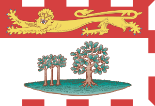
Geography of Prince Edward Island

Last updated

Prince Edward Island
PEI-basemap.png
Geography
Location Gulf of Saint Lawrence
Total islands62
Major islands1
Area5,683.91 km2 (2,194.57 sq mi)
Highest elevation140 m (460 ft) [1]
Highest point Springton Peak
Administration
Canada
Province Prince Edward Island
Largest settlement Charlottetown (pop. 36,094 (2016))
Demographics
Population142,907 (2016)
Pop. density25.25/km2 (65.4/sq mi)
Ethnic groups Scottish (38.0%), English (28.7%), Irish (27.9%), French (21.3%), German (4.0%), and Dutch (3.1%)

The geography of Prince Edward Island is mostly pastoral with red soil, white sand, and scattered communities. Known as the "Garden of the Gulf", the island is located in the Gulf of Saint Lawrence north of Nova Scotia and east of New Brunswick, with which it forms the Northumberland Strait.

Contents

Overview

Detailed map of Prince Edward Island PrinceEdwardIsland2022OSM.png
Detailed map of Prince Edward Island

Prince Edward Island (PEI) consists of the capital city Charlottetown, as well as urban towns Cornwall and Stratford and a developing urban fringe. A smaller urban area surrounds Summerside Harbour, situated on the southern shore 40 kilometres (25 mi) west of Charlottetown Harbour, and consists primarily of the city of Summerside. As with all natural harbours on the island, Charlottetown and Summerside harbours are created by rias. (See also a list of communities in Prince Edward Island.) The highest point of land is located at Springton in Queens County, rising 152 metres (499 ft) above sea level.

The island's landscape is pastoral; rolling hills, pristine forests, white sand beaches, ocean coves and the red soil have given PEI a reputation as a province of outstanding natural beauty.[ citation needed ] A number of laws have been passed by the provincial government to attempt to preserve the landscape through regulation, although the lack of consistent enforcement and absence of province-wide zoning and land-use planning has resulted in some unsightly development in recent years.

The island's lush landscape has had a strong bearing on the island's culture. During the late Victorian Era, author Lucy Maud Montgomery used the island as the setting of her novel Anne of Green Gables . Today, the island attracts tourists in all seasons, with popular leisure attractions including beaches, golf courses, and eco-tourism.

Communities

Most rural communities on Prince Edward Island are based on small-scale agriculture, and the average size of farm properties less than other areas in Canada. There is an increasing amount of industrial farming as older farm properties are consolidated and modernized.

Coastline

The coastline of the island consists of a combination of long beaches, dunes, red sandstone cliffs, saltwater marshes and numerous bays and harbours. The beaches, dunes and sandstone cliffs consist of sedimentary rock and other material with a high iron concentration which oxidizes upon exposure to the air. The geological properties of white silica sand found at Basin Head are unique in the province; the sand grains cause a scrubbing noise as they rub against each other under pressure. Large dune fields on the north shore can be found on barrier islands at the entrances to various bays and harbours. The sand dunes at Greenwich have a shifting, parabolic dune system that is home to a variety of birds and rare plants and is also a site of significant archaeological interest.

Climate

The climate of the island is a maritime climate considered to be moderate and strongly influenced by the surrounding seas. [2] [3] As such, it is milder than inland locations owing to the warm waters from the Gulf of St. Lawrence. [4] The climate is characterized by changeable weather throughout the year; it has some of the most variable day-to-day weather in Canada, in which specific weather conditions seldom last for long. [3]

Because the Gulf of Saint Lawrence freezes over, the island's climate is similar to a continental climate as opposed to an oceanic climate. Ice as far as the eye can see in the Gulf of St. Lawrence (39250866530).jpg
Because the Gulf of Saint Lawrence freezes over, the island's climate is similar to a continental climate as opposed to an oceanic climate.

During July and August, the average daytime high in PEI is 23 °C (73 °F); however, the temperature can sometimes exceed 30 °C (86 °F) during these months. In the winter months of January and February, the average daytime high is −3.3 °C (26 °F). The Island receives an average yearly rainfall of 855 millimetres (33.7 in) and an average yearly snowfall of 2,850 millimetres (112 in).

Winters are moderately cold and long but are milder than inland locations, with clashes of cold Arctic air and milder Atlantic air causing frequent temperature swings. [3] The climate is considered to be more humid continental climate than oceanic since the Gulf of St. Lawrence freezes over, thus eliminating any moderation. [3] The mean temperature is −7 °C (19 °F) in January. [4] During the winter months, the island usually has many storms (which may produce rain as well as snow) and blizzards since during this time, storms originating from the North Atlantic or the Gulf of Mexico frequently pass through. [3] Springtime temperatures typically remain cool until the sea ice has melted, usually in late April or early May.

Summers are moderately warm, but rarely uncomfortable, with the daily maximum temperature only occasionally reaching as high as 30 °C (86 °F). Autumn is a pleasant season, as the moderating Gulf waters delay the onset of frost, although storm activity increases compared to the summer. There is ample precipitation throughout the year, although it is heaviest in the late autumn, early winter and mid spring.

The following climate chart depicts the average conditions of Charlottetown, as an example of the small province's climate.

Climate data for Charlottetown Airport, 1981–2010 normals, extremes 1872–present [lower-alpha 1]
MonthJanFebMarAprMayJunJulAugSepOctNovDecYear
Record high °C (°F)15.1
(59.2)
13.3
(55.9)
24.5
(76.1)
26.7
(80.1)
31.7
(89.1)
32.2
(90.0)
33.9
(93.0)
36.7
(98.1)
31.5
(88.7)
27.8
(82.0)
21.3
(70.3)
16.7
(62.1)
36.7
(98.1)
Mean daily maximum °C (°F)−3.4
(25.9)
−2.9
(26.8)
0.9
(33.6)
7.2
(45.0)
14.3
(57.7)
19.4
(66.9)
23.3
(73.9)
22.8
(73.0)
18.6
(65.5)
12.3
(54.1)
6.3
(43.3)
0.5
(32.9)
9.9
(49.8)
Daily mean °C (°F)−7.7
(18.1)
−7.3
(18.9)
−3.1
(26.4)
3.1
(37.6)
9.2
(48.6)
14.5
(58.1)
18.7
(65.7)
18.3
(64.9)
14.1
(57.4)
8.3
(46.9)
2.9
(37.2)
−3.3
(26.1)
5.7
(42.3)
Mean daily minimum °C (°F)−12.1
(10.2)
−11.7
(10.9)
−7.0
(19.4)
−1.2
(29.8)
4.1
(39.4)
9.6
(49.3)
14.1
(57.4)
13.7
(56.7)
9.6
(49.3)
4.4
(39.9)
−0.5
(31.1)
−7.0
(19.4)
1.3
(34.3)
Record low °C (°F)−32.8
(−27.0)
−30.6
(−23.1)
−27.2
(−17.0)
−16.1
(3.0)
−6.7
(19.9)
−1.1
(30.0)
2.8
(37.0)
2.0
(35.6)
−0.6
(30.9)
−6.7
(19.9)
−17.2
(1.0)
−28.1
(−18.6)
−32.8
(−27.0)
Average precipitation mm (inches)101.0
(3.98)
83.2
(3.28)
86.3
(3.40)
83.7
(3.30)
91.0
(3.58)
98.8
(3.89)
79.9
(3.15)
95.7
(3.77)
95.9
(3.78)
112.2
(4.42)
112.5
(4.43)
118.1
(4.65)
1,158.2
(45.60)
Average rainfall mm (inches)34.1
(1.34)
29.8
(1.17)
44.1
(1.74)
59.7
(2.35)
87.2
(3.43)
98.8
(3.89)
79.9
(3.15)
95.7
(3.77)
95.9
(3.78)
110.3
(4.34)
93.0
(3.66)
58.6
(2.31)
887.1
(34.93)
Average snowfall cm (inches)73.3
(28.9)
58.3
(23.0)
44.1
(17.4)
24.4
(9.6)
3.7
(1.5)
0.0
(0.0)
0.0
(0.0)
0.0
(0.0)
0.0
(0.0)
1.7
(0.7)
19.2
(7.6)
65.6
(25.8)
290.4
(114.3)
Average precipitation days (≥ 0.2 mm)19.315.715.915.314.113.212.611.712.815.016.919.8182.4
Average rainy days (≥ 0.2 mm)6.35.07.511.613.813.212.611.712.814.613.08.6130.8
Average snowy days (≥ 0.2 cm)17.313.712.26.40.930.00.00.00.031.06.415.373.2
Mean monthly sunshine hours 108.9109.1141.3148.2197.1219.8253.6219.0181.0123.962.975.81,840.5
Percent possible sunshine 38.837.638.336.542.546.653.249.947.936.522.128.139.8
Source: Environment Canada [5] [6] [7] [8] [9]

See also

Notes

  1. Extreme high and low temperatures in the table below are from Charlottetown (April 1872 to December 1934), Charlottetown CDA (January 1935 to March 1943), and Charlottetown Airport (April 1943 to present).

Related Research Articles

<span class="mw-page-title-main">Prince Edward Island</span> Province of Canada

Prince Edward Island is one of the thirteen provinces and territories of Canada. While it is the smallest province in terms of land area and population, it is the most densely populated. The island has several nicknames: "Garden of the Gulf", "Birthplace of Confederation" and "Cradle of Confederation". Its capital and largest city is Charlottetown. It is one of the three Maritime provinces and one of the four Atlantic provinces.

<span class="mw-page-title-main">Magdalen Islands</span> Archipelago of Quebec, Canada

The Magdalen Islands are a small archipelago in the Gulf of Saint Lawrence with a land area of 205.53 square kilometres (79.36 sq mi). While part of the Province of Quebec, the islands are in fact closer to the Maritime provinces and Newfoundland than to the Gaspé Peninsula on the Quebec mainland. The islands constitute a part of the Epegwitg aq Pigtug district of Mi'kma'ki—the country of the Mi'kmaw Nation—who call the islands Menagoesenog.

<span class="mw-page-title-main">Northumberland Strait</span> Strait between Prince Edward Island, New Brunswick and Nova Scotia

The Northumberland Strait is a strait in the southern part of the Gulf of Saint Lawrence in eastern Canada. The strait is formed by Prince Edward Island and the gulf's eastern, southern, and western shores.

<span class="mw-page-title-main">Prince Edward Island National Park</span> National park on Prince Edward Island, Canada

Prince Edward Island National Park is a National Park of Canada located in the province of Prince Edward Island. Situated along the island's north shore, fronting the Gulf of St. Lawrence, the park measures approximately 60 km (37 mi) in length and ranges from several hundred metres to several kilometres in width. Established in 1937, the park's mandate includes the protection of many broad sand beaches, sand dunes and both freshwater wetlands and saltmarshes. The park's protected beaches provide nesting habitat for the endangered piping plover; the park has been designated a Canadian Important Bird Area.

<span class="mw-page-title-main">Summerside, Prince Edward Island</span> City in Prince Edward Island, Canada

Summerside is a Canadian city in Prince County, Prince Edward Island. It is the second largest city in the province and the primary service centre for the western part of the island.

<span class="mw-page-title-main">Prince Edward Island Railway</span> Historic Canadian railway

The Prince Edward Island Railway (PEIR) was a historic Canadian railway in Prince Edward Island (PEI). The railway ran tip-to-tip on the island, from Tignish in the west to Elmira in the east, with major spurs serving Borden-Carleton's train ferry dock, the capital in Charlottetown, Montague and Georgetown and the original eastern terminus at Souris. A major spur from Charlottetown served Murray Harbour on the south coast.

<span class="mw-page-title-main">Tignish</span> Town in Prince Edward Island, Canada

Tignish is a Canadian town located in Prince County, Prince Edward Island.

<span class="mw-page-title-main">Norderney</span> Town in Lower Saxony, Germany

Norderney is one of the seven populated East Frisian Islands off the North Sea coast of Germany.

The Halifax Regional Municipality (HRM) in Nova Scotia, Canada has a widely varied geography.

<span class="mw-page-title-main">North Rustico</span> Town in Prince Edward Island, Canada

North Rustico is a Canadian town located in Queens County, Prince Edward Island.

Alberton is a Canadian town located in Prince County, Prince Edward Island. It is situated in the western part of the county in the township of Lot 5.

<span class="mw-page-title-main">Geography of Toronto</span> Geography of the city of Toronto, Canada

The geography of Toronto, Ontario, covers an area of 630 km2 (240 sq mi) and is bounded by Lake Ontario to the south; Etobicoke Creek, Eglinton Avenue, and Highway 427 to the west; Steeles Avenue to the north; and the Rouge River and the Scarborough–Pickering Townline to the east. In addition to Etobicoke Creek and the Rouge River, the city is trisected by two minor rivers and their tributaries, the Humber River in the west end and the Don River east of downtown. Both flow southward to Lake Ontario at Humber Bay and Toronto Harbour respectively, which are part of the longer Waterfront, as well as Etobicoke Creek and the Rouge River.

<span class="mw-page-title-main">Georgetown, Prince Edward Island</span> Place in Prince Edward Island, Canada

Georgetown is a community located within the municipality of Three Rivers in Kings County, Prince Edward Island, Canada. It is the Capital of Kings County. Previously incorporated as a town, it amalgamated with the town of Montague, the rural municipalities of Brudenell, Cardigan, Lorne Valley, Lower Montague, and Valleyfield, and portions of three adjacent unincorporated areas in 2018.

<span class="mw-page-title-main">Prince Edward Island Route 2</span>

Route 2, also known as Veterans Memorial Highway and the All Weather Highway, is a 216-kilometre (134 mi) two-lane uncontrolled access highway traversing Prince Edward Island, Canada from Tignish to Souris. Route 2 was recognized as the first numbered highway in the province in 1890, when it opened between Charlottetown and Summerside.

<span class="mw-page-title-main">Malpeque Bay</span> Estuarine bay in Canada

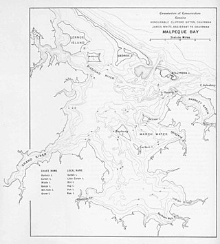
Malpeque Bay is a 204 km2 (79 sq mi) estuarine bay on the north shore of Prince Edward Island, Canada.

<span class="mw-page-title-main">Temperature in Canada</span>

Climate in Canada varies widely from region to region. In many parts of the country, particularly in the interior and Prairie provinces, winters are long, very cold, and feature frequent snow. Most of Canada has a continental climate, which features a large annual range of temperatures, cold winters, and warm summers. Daily average temperatures are near −15 °C (5 °F), but can drop below −50 °C (−58 °F) with severe wind chills. In non-coastal regions, snow can cover the ground for almost six months of the year, while in parts of the north snow can persist year-round. Coastal British Columbia has a more temperate climate, with a mild and rainy, cloudy winter. On the east and west coasts, average high temperatures are generally in the low 20s °C, while between the coasts, the average summer high temperature ranges from 25 to 30 °C, with temperatures in some interior locations occasionally exceeding 40 °C (104 °F).

<span class="mw-page-title-main">Charlottetown</span> Capital city of Prince Edward Island, Canada

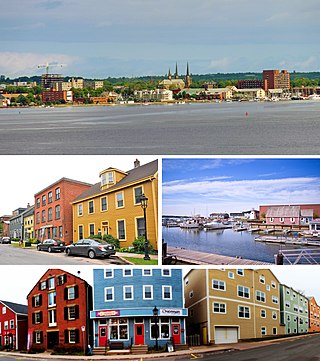
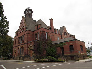
Charlottetown is the capital and largest city of the Canadian province of Prince Edward Island, and the county seat of Queens County. Named after Queen Charlotte, Charlottetown was an unincorporated town until it was incorporated as a city in 1855.

Public Schools Branch (PSB), formerly the English Language School Board or ELSB, is a Canadian school district in Prince Edward Island.

<span class="mw-page-title-main">Island Storm</span> Basketball team in Charlottetown, Canada

The Island Storm is an inactive Canadian professional basketball team based in Charlottetown, Prince Edward Island. The team is a charter member of the National Basketball League of Canada that began play in the 2011–12 season. The Storm plays its home games at the Eastlink Centre. Former Vermont Frost Heaves head coach Joe Salerno served as the team's head coach for the first six seasons until he parted ways with the team in May 2017. In 2021, the Storm were granted a one-year leave of absence after they were the last remaining team based in the Maritimes.

<span class="mw-page-title-main">Climate of Nova Scotia</span>

Nova Scotia lies in the mid-temperate zone, and although the province is almost surrounded by water, the climate is closer to continental climate rather than maritime climate. The temperature extremes of the continental climate are moderated by the ocean.

References

  1. "Prince Edward Island High Point, Prince Edward Island". Peakbagger. Retrieved 27 January 2023.
  2. "Prince Edward Island". The Canadian Encyclopedia . Archived from the original on 8 June 2019. Retrieved 1 September 2019.
  3. 1 2 3 4 5 "The Climate of Prince Edward Island". The Climates of Canada. Environment Canada. Archived from the original on 20 September 2008. Retrieved 7 June 2015.
  4. 1 2 "Climate and Weather". Government of Prince Edward Island. Archived from the original on 14 June 2015. Retrieved 7 June 2015.
  5. "Canadian Climate Normals 1971-2000". Environment Canada. Archived from the original on 13 May 2013. Retrieved 5 October 2012.
  6. "Charlottetown A". Canadian Climate Normals 1981–2010. Environment Canada. 25 September 2013. Archived from the original on 28 July 2019. Retrieved 9 April 2016.
  7. "Charlottetown". Canadian Climate Data. Environment Canada. 31 October 2011. Archived from the original on 14 October 2018. Retrieved 29 February 2016.
  8. "Charlottetown CDA". Canadian Climate Normals 1971–2000. Environment Canada. 31 October 2011. Archived from the original on 20 April 2016. Retrieved 9 April 2016.
  9. "March 2012". Canadian Climate Data. Environment Canada. 31 October 2011. Archived from the original on 14 October 2018. Retrieved 9 June 2016.