Inuvik Region

Last updated
Inuvik Region
Inuvik skyline.jpg
Inuvik skyline
NWT Locator Inuvik.svg
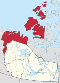
Location within the Northwest Territories
CountryCanada
Territory Northwest Territories
Federal riding Northwest Territories
Territorial ridings Inuvik Boot Lake
Inuvik Twin Lakes
Mackenzie Delta
Nunakput
Regional office [1] Inuvik
Population
 (2016)
  Total6,372
Time zone UTC−07:00 (MST)
  Summer (DST) UTC−06:00 (DST)
NWT All Region Locator.svg
Inuvik Region communities in the Northwest Territories

The Inuvik Region or Beaufort Delta Region is one of five administrative regions in the Northwest Territories of Canada. According to Municipal and Community Affairs the region consists of eight communities with the regional office situated in Inuvik. [1] Most of the communities are in the Beaufort Sea area and are a mixture of Inuit (Inuvialuit) and First Nations (mostly Gwich'in).

Contents

Formerly, there was also a Statistics Canada designated census division named Inuvik Region, Northwest Territories, which was abolished in the 2011 Canadian Census. The territorial extent of this census division was somewhat larger than the administrative region of the same name.

Administrative Region communities

The Inuvik Region administrative entity includes the following communities:

Communities of the Inuvik Region
CommunityDemographics (2016)
Name [2] Type [3] Census [4] Aboriginal population profile [5]
OfficialTraditionalTotal First Nations Métis Inuit Other
Aklavik AkłarvikHamlet59022020375160
Fort McPherson Teetł'it ZhehHamlet700625257595
Inuvik InuuvikTown3,243880801,4601,375
Paulatuk PaulatuuqHamlet2650021555
Sachs Harbour IkaahukHamlet1031009035
Tsiigehtchic TsiigehtshikCharter community17213503550
Tuktoyaktuk TuktuujaqrtuuqHamlet898700795175
Ulukhaktok UlukhaqtuuqHamlet3960037040
Historical population
YearPop.±%
20016,972    
20027,087+1.6%
20037,077−0.1%
20047,059−0.3%
20057,085+0.4%
20066,996−1.3%
20076,969−0.4%
20086,957−0.2%
20096,953−0.1%
YearPop.±%
20106,996+0.6%
20116,949−0.7%
20126,909−0.6%
20136,826−1.2%
20146,756−1.0%
20156,706−0.7%
20166,717+0.2%
20176,673−0.7%
Sources: NWT Bureau of Statistics (2001 - 2017) [6]

Related Research Articles

Northwest Territories Territory of Canada

The Northwest Territories is a federal territory of Canada. At a land area of approximately 1,144,000 km2 (442,000 sq mi) and a 2016 census population of 41,790, it is the second-largest and the most populous of the three territories in Northern Canada. Its estimated population as of 2021 is 45,515. Yellowknife is the capital, most populous community, and only city in the territory; its population was 19,569 as of the 2016 census. It became the territorial capital in 1967, following recommendations by the Carrothers Commission.

Inuvik town above Arctic Circle in Canadas Northwest Territories

Inuvik is a town in the Northwest Territories of Canada, and hosts the regional office of the Inuvik Region. Inuvik is both a Gwich'in and an Inuvialuit community. The community, like Aklavik, is located in both the Gwich'in Settlement Area and the Inuvialuit Settlement Region.

Aklavik Hamlet in Northwest Territories, Canada

Aklavik is a hamlet located in the Inuvik Region of the Northwest Territories, Canada. Until 1961, with a population over 1,500, the community served as the regional administrative centre for the territorial government.

Kitikmeot Region Region in Nunavut, Canada

Kitikmeot Region is an administrative region of Nunavut, Canada. It consists of the southern and eastern parts of Victoria Island with the adjacent part of the mainland as far as the Boothia Peninsula, together with King William Island and the southern portion of Prince of Wales Island. The regional centre is Cambridge Bay.

Tsiigehtchic Charter Community in Northwest Territories, Canada

Tsiigehtchic, officially the Charter Community of Tsiigehtchic, is a Gwich'in community located at the confluence of the Mackenzie and the Arctic Red Rivers, in the Inuvik Region of the Northwest Territories, Canada. The community was formerly known as Arctic Red River, until 1 April 1994. The Gwichya Gwich'in First Nation is located in Tsiigehtchic.

Sachs Harbour Hamlet in Northwest Territories, Canada

Sachs Harbour is a hamlet located in the Inuvik Region of the Northwest Territories, Canada. Situated on the southwestern coast of Banks Island in the Inuvialuit Settlement Region, the population according to the 2016 census count was 103 people. Sachs Harbour is the only permanent settlement on Banks Island.

Fort Good Hope Charter Community in Northwest Territories, Canada

Fort Good Hope, is a charter community in the Sahtu Region of the Northwest Territories, Canada. It is located on a peninsula between Jackfish Creek and the east bank of the Mackenzie River, about 145 km (90 mi) northwest of Norman Wells. The two principal languages are North Slavey and English. Hunting and trapping are two major sources of income. The Church of Our Lady of Good Hope, a National Historic Site, is located in the community. The church, completed in 1885, was once home to Father Émile Petitot.

Fort McPherson, Northwest Territories Hamlet in Northwest Territories, Canada

Fort McPherson is a hamlet located in the Inuvik Region of the Northwest Territories, Canada. It is located on the east bank of the Peel River and is 121 km (75 mi) south of Inuvik on the Dempster Highway.

Sahtu Region Administrative region in Northwest Territories, Canada

The Sahtu Region is an administrative region in Canada's Northwest Territories. Coterminous with the settlement region described in the 1993 Sahtu Dene and Metis Comprehensive Land Claim Agreement, 41,437 km2 (15,999 sq mi) of the Sahtu is collectively owned by its Indigenous Sahtu (Dene) and Métis inhabitants. Although the region's population is predominantly First Nations, a significant non-Indigenous presence exists in Norman Wells, the regional office, established in 1920 to serve the only producing oilfield in the Canadian Territories. Considered to be of vital strategic importance during World War II in the event of a Japanese invasion of Alaska, the region's petroleum resources were exploited by the United States Army with the Canol pipeline, but the project never became necessary and ultimately operated for less than one year.

Dehcho Region Administrative region in Northwest Territories, Canada

The Dehcho Region or Deh Cho is one of five administrative regions in the Northwest Territories of Canada. According to Municipal and Community Affairs the region consists of six communities with the regional office situated in Fort Simpson. All communities in the Dehcho are predominantly Dehcho First Nations.

North Slave Region Administrative region in Northwest Territories, Canada

The North Slave Region or Tłicho Region is one of five administrative regions in the Northwest Territories of Canada. It is the most populous of the five regions, with a population of almost 23,000. According to Municipal and Community Affairs the region consists of eight communities with the regional office situated in Yellowknife and a sub-office in Behchokǫ̀. With the exception of Yellowknife, the communities are predominantly First Nations.

South Slave Region Administrative region in Northwest Territories, Canada

The South Slave Region is one of five administrative regions in the Northwest Territories of Canada. According to Municipal and Community Affairs the region consists of seven communities with the regional office situated in Fort Smith and a sub-office in Hay River. With the exception of Enterprise and Hay River the communities are predominantly First Nations.

Inuvialuit Settlement Region Region in Canada

The Inuvialuit Settlement Region, abbreviated as ISR, located in Canada's western Arctic, was designated in 1984 in the Inuvialuit Final Agreement by the Government of Canada for the Inuvialuit people. It spans 90,650 km2 (35,000 sq mi) of land, mostly above the tree line, and includes several subregions: the Beaufort Sea, the Mackenzie River delta, the northern portion of Yukon, and the northwest portion of the Northwest Territories. The ISR includes both Crown Lands and Inuvialuit Private Lands.

Inuvik Region was a former Statistics Canada census division, one of two in the Northwest Territories, Canada. It was abolished in the 2011 census, along with the other census division of Fort Smith Region, and the land area of the Northwest Territories was divided into new census divisions named Region 1, Region 2, Region 3, Region 4, Region 5, Region 6.

Region 1 is the name of a Statistics Canada census division, one of six in the Northwest Territories, Canada. It was introduced in the 2011 census, along with Regions 2, 3, 4, 5 and 6, resulting in the abolition of the former census divisions of Fort Smith Region and Inuvik Region. Unlike in some other provinces, census divisions do not reflect the organization of local government in the Northwest Territories. These areas exist solely for the purposes of statistical analysis and presentation; they have no government of their own.

Region 2 is the name of a Statistics Canada census division, one of six in the Northwest Territories, Canada. It was introduced in the 2011 census, along with Regions 1, 3, 4, 5 and 6, resulting in the abolition of the former census divisions of Fort Smith Region and Inuvik Region. Unlike in some other provinces, census divisions do not reflect the organization of local government in the Northwest Territories. These areas exist solely for the purposes of statistical analysis and presentation; they have no government of their own.

Region 3 is the name of a Statistics Canada census division, one of six in the Northwest Territories, Canada. It was introduced in the 2011 census, along with Regions 1, 2, 4, 5, and 6, resulting in the abolition of the former census divisions of Fort Smith Region and Inuvik Region. Unlike in some other provinces, census divisions do not reflect the organization of local government in the Northwest Territories. These areas exist solely for the purposes of statistical analysis and presentation; they have no government of their own.

References

  1. 1 2 Inuvik Region
  2. "Northwest Territories Official Community Names and Pronunciation Guide". Prince of Wales Northern Heritage Centre . Yellowknife: Education, Culture and Employment, Government of the Northwest Territories. Archived from the original on 2016-01-13. Retrieved 2016-01-13.
  3. "Differences in Community Government Structures" (PDF). Maca.gov.nt.ca. Retrieved 18 December 2014.
  4. "Population and dwelling counts, for Canada, provinces and territories, and census subdivisions (municipalities), 2016 and 2011 censuses – 100% data".
  5. "Aboriginal Population Profile, 2016 census". Statistics Canada. Retrieved 1 July 2019.
  6. Population Estimates By Community from the GNWT
Map this section's coordinates using: OpenStreetMap  
Download coordinates as: KML

Coordinates: 68°21′42″N133°43′50″W / 68.36167°N 133.73056°W / 68.36167; -133.73056 (Inuvik Region centred on Inuvik)