Related Research Articles
Yellowknife is the capital, largest community, and only city in the Northwest Territories, Canada. It is on the northern shore of Great Slave Lake, about 400 km (250 mi) south of the Arctic Circle, on the west side of Yellowknife Bay near the outlet of the Yellowknife River.

Tulita, which in Slavey means "where the rivers or waters meet," is a hamlet in the Sahtu Region of the Northwest Territories, Canada. It was formerly known as Fort Norman, until 1 January 1996. It is located at the junction of the Great Bear River and the Mackenzie River; the Bear originates at Great Bear Lake adjacent to Deline.
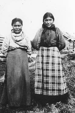
The Slavey are a First Nations indigenous peoples of the Dene group, indigenous to the Great Slave Lake region, in Canada's Northwest Territories, and extending into northeastern British Columbia and northwestern Alberta.

Great Slave Lake, known traditionally as Tıdeè in Tłı̨chǫ Yatıì (Dogrib), Tinde’e in Wıìlıìdeh Yatii / Tetsǫ́t’ıné Yatıé, Tu Nedhé in Dëne Sųłıné Yatıé (Chipewyan), and Tucho in Dehcho Dene Zhatıé (Slavey), is the second-largest lake in the Northwest Territories of Canada, the deepest lake in North America at 614 m (2,014 ft), and the tenth-largest lake in the world by area. It is 469 km (291 mi) long and 20 to 203 km wide. It covers an area of 27,200 km2 (10,500 sq mi) in the southern part of the territory. Its given volume ranges from 1,070 km3 (260 cu mi) to 1,580 km3 (380 cu mi) and up to 2,088 km3 (501 cu mi) making it the 10th or 12th largest by volume.
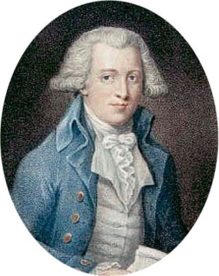
Samuel Hearne was an English explorer, fur-trader, author, and naturalist. He was the first European to make an overland excursion across northern Canada to the Arctic Ocean, actually Coronation Gulf, via the Coppermine River. In 1774, Hearne built Cumberland House for the Hudson's Bay Company, its second interior trading post after Henley House and the first permanent settlement in present Saskatchewan.

Fort Smith is a town in the South Slave Region of the Northwest Territories (NWT), Canada. It is located in the southeastern portion of the Northwest Territories, on the Slave River and adjacent to the Alberta border along the 60th parallel north.

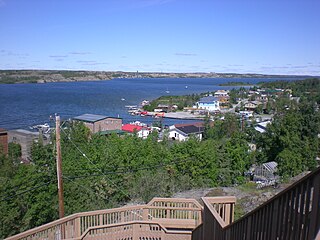
Fort Resolution is a hamlet in the South Slave Region of the Northwest Territories, Canada. The community is situated at the mouth of the Slave River, on the shores of Great Slave Lake, and at the end of the Fort Resolution Highway. It is the headquarters of the Deninu Kųę́ First Nation, whose Chief is Louis Balsillie.
Fort Providence is a hamlet in the South Slave Region of the Northwest Territories, Canada. Located west of Great Slave Lake, it has all-weather road connections by way of the Yellowknife Highway branch off the Mackenzie Highway, and the Deh Cho Bridge opened November 30, 2012, near Fort Providence over the Mackenzie. The bridge replaced the ice bridge and ferry, enabling year-round crossing of the river.
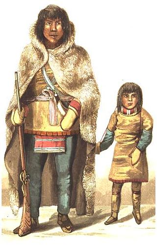
The Yellowknives, Yellow Knives, Copper Indians, Red Knives or T'atsaot'ine are indigenous peoples of Canada, one of the five main groups of the First Nations Dene who live in the Northwest Territories of Canada. The name, which is also the source for the later community of Yellowknife, derives from the colour of the tools made from copper deposits.

Behchokǫ̀, officially the Tłı̨chǫ Community Government of Behchokǫ̀, is a community in the North Slave Region of the Northwest Territories, Canada. Behchokǫ̀ is located on the Yellowknife Highway, on the northwest tip of Great Slave Lake, approximately 110 km (68 mi) northwest of Yellowknife.

The history of the Northwest Territories covers the period from thousands of years ago to the present day. Prior to European colonization, the lands that encompass present-day Northwest Territories were inhabited for millennia by several First Nations. European explorers and fur traders began to explore the region since the late-16th century. By the 17th century, the British laid claim to both the North-Western Territory and Rupert's Land; and granted the Hudson's Bay Company a commercial fur trade monopoly over the latter region.
Fort Smith Region was a former Statistics Canada census division, one of two in the Northwest Territories, Canada. It was abolished in the 2011 census, along with the other census division of Inuvik Region, and the land area of the Northwest Territories was divided into new census divisions named Region 1, Region 2, Region 3, Region 4, Region 5, Region 6.

The Northwest Territories is a territory in Northern Canada, specifically in Northwestern Canada between Yukon Territory and Nunavut including part of Victoria Island, Melville Island, and other islands on the western Arctic Archipelago. Originally a much wider territory enclosing most of central and northern Canada, the Northwest Territories was created in 1870 from the Hudson's Bay Company's holdings that were sold to Canada from 1869-1870. In addition, Alberta and Saskatchewan were formed from the territory in 1905. In 1999, it was divided again: the eastern portion became the new territory of Nunavut. Yellowknife stands as its largest city and capital. It has a population of 42,800 and has an area of 532,643 sq mi (1,379,540 km2). The current territory lies west of Nunavut, north of latitude 60° north, and east of Yukon.
The Yellowknife Education District No. 1 is the public school board in Yellowknife, Northwest Territories. The district, then called Yellowknife School District No. 1, was created 1 October 1939 by Charles Camsell who was Commissioner of the Northwest Territories.

The Mackenzie River in Canada's Northwest Territories is a historic waterway, used for centuries by Indigenous peoples, specifically the Dene, as a travel and hunting corridor. Also known as the Deh Cho, it is part of a larger watershed that includes the Slave, Athabasca, and Peace rivers extending from northern Alberta. In the 1780s, Peter Pond, a trader with the North West Company became the first known European to visit this watershed and begin viable trade with the Athapascan-speaking Dene of these rivers. The Mackenzie River itself, the great waterway extending to the Arctic Ocean, was first put on European maps by Alexander Mackenzie in 1789, the Scottish trader who explored the river. The watershed thus became a vital part of the North American fur trade, and before the advent of the airplane or road networks, the river was the only communication link between northern trading posts and the south. Water travel increased in the late 19th century as traders, dominated primarily by the Hudson's Bay Company (HBC), looked to increase water services in the Mackenzie River District.

The Charter Community of Délı̨nę is located in the Sahtu Region of the Northwest Territories, Canada, on the western shore of Great Bear Lake and is 544 km (338 mi) northwest of Yellowknife. Délı̨nę means "where the waters flow", a reference to the headwaters of the Great Bear River, Sahtúdé. It is the only settlement on the shores of Great Bear Lake as Fort Confidence was last used in the 1800s and Port Radium closed in 1982.
François Beaulieu II was a chief of the Yellowknife tribe. He was an Arctic guide and interpreter who played an important role in exploration of the Northwest Territories of Canada.
Akaitcho was a Copper Indian, and Chief of the Yellowknives. His territory included the region from the eastern portion of the Great Slave Lake, in the Northwest Territories, Canada, to the Coppermine River, in Nunavut. He was recruited to act as interpreter, guide, and hunter for John Franklin's first of three Arctic expeditions, the Coppermine Expedition of 1819–1822.
The North Slave Métis Alliance is a non-profit society that represents the indigenous rights-bearing Métis people of the Northwest Territories, who primarily exercise their indigenous rights north and east of Great Slave Lake. The NSMA’s mandate includes: The assertion, protection, and implementation of the indigenous rights of the North Slave Métis People; and the exercise of Métis responsibility to protect the environment and to promote and enhance Métis education, economic, social, and cultural development. The NSMA is vitally concerned with the protection, preservation, and sustainable use of its traditional lands and resources. With that in mind, the NSMA is committed to principles of economic sustainability, environmental stewardship, and self-determination in respect to its traditional lands and resources.
Rocher River is an abandoned community in the South Slave Region of the Northwest Territories, Canada. The community was situated near the mouth of the Taltson River, which drains into Great Slave Lake. Dene trading chief Pierre Snuff built the first cabins in this area in the early 20th century, on what is called Snuff Channel, east of the later village. By 1921, the Hudson's Bay Company established a trading post at Rocher River. Independent traders followed including Northern Traders Limited (1923), Frank Morrison (1924), and Ed Demelt (1935) and the area grew into a bustling trading centre. At the time, the area was a very rich hunting and trapping area for the Dene and Metis people living on the south shore of Great Slave Lake including the Slavey, Chipeywan, and Yellowknives tribes. By the 1950s Rocher River included a government day school, two trading posts, post office, and a church, with a population of about 150. The manager of the Hudson's Bay Company post at Rocher River in the early 1940s was Ralph Jardine. On April 25, 1944, the warehouses of the HBC burned down but were immediately rebuilt.
References
- ↑ Perry, B. Dale and W. Dean Clark. Fort Providence, NWT: A preliminary report of the excavations carried out July 1969. The Musk-ox, No. 8, 1971