Paulatuk Paulatuuq | |
---|---|
Coordinates: 69°21′05″N124°04′10″W / 69.35139°N 124.06944°W | |
Country | Canada |
Territory | Northwest Territories |
Region | Inuvik Region |
Constituency | Nunakput |
Census division | Region 1 |
Incorporated (hamlet) | 1 April 1987 |
Government | |
• Mayor | Ray Ruben Sr. |
• Senior Administrative Officer | John Holland |
• MLA | Jackie Jacobson |
Area | |
• Land | 66.86 km2 (25.81 sq mi) |
Elevation | 5 m (16 ft) |
Population (2021) [1] | |
• Total | 298 |
• Density | 4.0/km2 (10/sq mi) |
Time zone | UTC−07:00 (MS) |
• Summer (DST) | UTC−06:00 (MDT) |
Canadian Postal code | X0E 1N0 |
Area code | 867 |
Telephone exchange | 580 |
- Living cost | 177.5 A |
- Food price index | 195.9 B |
Sources: Department of Municipal and Community Affairs, [2] Prince of Wales Northern Heritage Centre, [3] Canada Flight Supplement [4] ^A 2009 figure based on Edmonton = 100 [5] ^B 2010 figure based on Yellowknife = 100 [5] |
Paulatuk[ pronunciation? ] is a hamlet located in the Inuvik Region of the Northwest Territories, Canada. It is located adjacent to Darnley Bay, in the Amundsen Gulf. The town was named for the coal that was found in the area in the 1920s, and the Siglitun spelling is Paulatuuq[ pronunciation? ], "place of coal". [3]
The area has been inhabited by humans, including the Thule and Copper Inuit, since roughly 1000 CE. Most recently, it is part of the Inuvialuit Settlement Region. [6] Paulatuk was incorporated as a hamlet in 1987 and celebrated the 50th anniversary of its settlement in 2015. [7]
|
| ||||||||||||||||||||||||||||||||||||||||||||||||||||||||||||||||||||||||
Sources: NWT Bureau of Statistics (2001 - 2017) [16] |
In the 2021 Census of Population conducted by Statistics Canada, Paulatuk had a population of 298 living in 81 of its 100 total private dwellings, a change of 12.5% from its 2016 population of 265. With a land area of 63.58 km2 (24.55 sq mi), it had a population density of 4.7/km2 (12.1/sq mi) in 2021. [15]
In the 2016 census 235 people were listed as Indigenous and all were Inuit (Inuvialuit). The two principal languages spoken in Paulatuk are Inuinnaqtun (Inuvialuktun) and English. [1]
European settlement began when the Roman Catholic Church opened a trading post. In the 1950s a Distant Early Warning Line site was built about 95 km (59 mi) to the northwest at Cape Parry, on the Parry Peninsula, providing a wage-based income for the community. The trading post was taken over by the local co-op and today the local store is part of The North West Company. [17] [18]
Hunting, fishing and trapping are major economic activities, but in recent years art printmaking has played an increasing role in the local economy. [17]
The Smoking Hills which are about 105 km (65 mi) west on the shores of the Arctic Ocean are a scientifically interesting object, since they are diminishing the pH value of the water areas. So the buffer effect has completely disappeared. Located to the east of the community is Tuktut Nogait National Park and Parks Canada has an office in the community. [18]
Paulatuk's Inuit artists are known across Canada and around the world for dance, music, sculptures, prints, and drawings.
Floyd Kuptana was born in 1964. He studied under David Ruben Piqtoukun and began solo work in 1992. He is a carver, sculptor, and painter. [19]
Robert Kuptana was born in 1962. A carver since his youth, he studied under his brother Floyd and began professional work in 1998. [20]
The Paulatuk Moonlight Dancers are a group of traditional Inuvialuit dancers. They have performed in Canada, the United States, Greenland, and Germany, and are led by Michael “Nolan” Green. Green also served as a hamlet councillor and received a Canada Youth Award in 2002. [21]
Abraham Anghik Ruben was born south of Paulatuk in 1951 and lived on the land with his family until he was eight years old. He currently lives on Salt Spring Island. [22]
His 2001 sculpture The Last Goodbye reflects Ruben and his brothers' experiences of being separated from their family by Canada's residential school system. Ruben writes,
I clearly remember when this took place—my mother sitting with my older brother and sister, David and Martha, just before they left for the Mission school in Aklavik. David was five years old at the time and Martha was only a little older. It was a scene that was repeated later on when my other brothers and I were sent off to residential school. But this time, it was sadder for my mother, because it would be three years that David and Martha would be gone. They left in 1955 and we didn’t see them again until the latter part of 1958. Those three years had a permanent impact on my brother’s life." [23]
Abraham Anghik Ruben became an Officer in the Order of Canada on November 17, 2016 for his artistic contributions as a sculptor and for his preservation of northern heritage.
David Ruben Piqtoukun was born in Paulatuk in 1950. A sculptor and print artist, he is also brother to Abraham Anghik Ruben and was a mentor to Floyd Kuptana. [19]
A mayor has led the hamlet since its incorporation in 1987, when the first mayor, Garrett Ruben, was elected. Ruben was also a community leader before incorporation. As a young man he worked near the Distant Early Warning (DEW) Line site at Cape Parry, but the area was isolated and far from traditional hunting grounds. After leaving this work, he negotiated for the community locally and in the south and became Settlement Chair prior to serving as mayor. Ruben died in 2007 at the age of 72. The hamlet has formally recognized him for his 24 years of service. Ray Ruben, the sixth and current mayor, is his son. [24]
Paulatuk elder Anny Illasiak, also known as Granny Uma, died in 2012 at the age of 74. A resident of Paulatuk since the 1970s, Illasiak was a leader in training children and young people to live on the land. She also organized a community sewing group, teaching others to make traditional clothing and creating tapestries herself, and volunteered as a cook with the Paulatuk Community Kitchen. She served as the Aboriginal language teacher for the Paulatuk Aboriginal Headstart Program for 10 years and continued to assist with the program after her retirement. [25]
Elizabeth "Liz" Kuptana, recipient of the Wallace Goose Award (given to those who have “shown beyond a shadow of a doubt, that he or she has unselfishly dedicated time, effort, and sometimes blood, sweat, and tears for the advancement and benefit of all Inuvialuit”) is a Paulatuk elder, teacher, and storyteller. She teaches children and youth about Inuvialuit culture and language as well as the history of the Inuvialuit Final Agreement. [26] She was awarded the Queen Elizabeth II Diamond Jubilee Medal in 2013. [27]
Paulatuuq Oral History Project: Elders Share Their Stories was published in 2004. [28] Eight community elders, including Edward Ruben and Mary Evik Ruben, contributed to this record of the hamlet's oral history, completing interviews transcribed by Cathy Cockney. [29]
Services include a two-member Royal Canadian Mounted Police detachment and a health centre with two nurses. [30] Phone services are provided by Northwestel with Internet by SSI Micro and their AirWare service. [31]
The community is part of the Beaufort Delta Education Council [32] and schooling is available up to Grade 12 at the Angik School. [17] [33] There is also a community learning centre operated by Aurora College. [17] [18]
The community is not accessible by road but there is an airport, Paulatuk (Nora Aliqatchialuk Ruben) Airport, and flights into the community are provided by Aklak Air from Inuvik three times a week. [34] In the summer floatplanes can use the Paulatuk Water Aerodrome and an annual sealift is provided by Northern Transportation Company Limited from Hay River. [35]
Paulatuk has a subarctic climate (Dfc), narrowly avoiding being a tundra climate (ET) due to July having an average temperature above 10 °C (50 °F). Rainfall is in limited amounts and confined to the months of June - September because all other months don't have an average temperature above freezing, which would be warm enough for rain.
Climate data for Paulatuk (Nora Aliqatchialuk Ruben) Airport | |||||||||||||
---|---|---|---|---|---|---|---|---|---|---|---|---|---|
Month | Jan | Feb | Mar | Apr | May | Jun | Jul | Aug | Sep | Oct | Nov | Dec | Year |
Record high humidex | −1.4 | −3.0 | −0.7 | 9.4 | 21.8 | 29.8 | 33.4 | 29.1 | 22.7 | 15.5 | 3.2 | 1.3 | 33.4 |
Record high °C (°F) | −0.9 (30.4) | −1.6 (29.1) | 0.5 (32.9) | 10.5 (50.9) | 18.0 (64.4) | 27.5 (81.5) | 30.3 (86.5) | 30.0 (86.0) | 22.3 (72.1) | 16.5 (61.7) | 7.6 (45.7) | −1.5 (29.3) | 30.3 (86.5) |
Average high °C (°F) | −21.8 (−7.2) | −22.2 (−8.0) | −19.2 (−2.6) | −9.4 (15.1) | 0.0 (32.0) | 10.3 (50.5) | 14.4 (57.9) | 12.2 (54.0) | 6.0 (42.8) | −3.3 (26.1) | −14.4 (6.1) | −18.3 (−0.9) | −5.5 (22.1) |
Daily mean °C (°F) | −25.6 (−14.1) | −26.2 (−15.2) | −23.5 (−10.3) | −14.3 (6.3) | −3.9 (25.0) | 5.9 (42.6) | 10.1 (50.2) | 8.7 (47.7) | 3.3 (37.9) | −6.0 (21.2) | −17.9 (−0.2) | −22.0 (−7.6) | −9.3 (15.3) |
Average low °C (°F) | −29.3 (−20.7) | −30.0 (−22.0) | −27.7 (−17.9) | −19.1 (−2.4) | −7.7 (18.1) | 1.5 (34.7) | 5.7 (42.3) | 5.1 (41.2) | 0.7 (33.3) | −8.6 (16.5) | −21.3 (−6.3) | −25.7 (−14.3) | −13.0 (8.6) |
Record low °C (°F) | −42.0 (−43.6) | −44.4 (−47.9) | −46.9 (−52.4) | −36.8 (−34.2) | −31.0 (−23.8) | −6.4 (20.5) | −3.0 (26.6) | −3.2 (26.2) | −11.0 (12.2) | −34.1 (−29.4) | −37.5 (−35.5) | −38.7 (−37.7) | −46.9 (−52.4) |
Record low wind chill | −57.0 | −56.7 | −58.9 | −45.7 | −35.9 | −11.4 | −6.7 | −7.9 | −18.5 | −50.4 | −48.6 | −53.1 | −58.9 |
Average precipitation mm (inches) | 12.0 (0.47) | 10.3 (0.41) | 13.3 (0.52) | 9.5 (0.37) | 14.4 (0.57) | 14.3 (0.56) | 21.9 (0.86) | 34.5 (1.36) | 24.7 (0.97) | 25.4 (1.00) | 18.1 (0.71) | 14.4 (0.57) | 212.9 (8.38) |
Average rainfall mm (inches) | 0.0 (0.0) | 0.0 (0.0) | 0.0 (0.0) | 0.0 (0.0) | 3.1 (0.12) | 13.6 (0.54) | 21.9 (0.86) | 34.1 (1.34) | 18.7 (0.74) | 1.4 (0.06) | 0.1 (0.00) | 0.0 (0.0) | 92.9 (3.66) |
Average snowfall cm (inches) | 14.2 (5.6) | 10.7 (4.2) | 15.5 (6.1) | 11.3 (4.4) | 11.5 (4.5) | 0.7 (0.3) | 0.0 (0.0) | 0.4 (0.2) | 6.1 (2.4) | 25.1 (9.9) | 19.3 (7.6) | 17.1 (6.7) | 131.8 (51.9) |
Average precipitation days (≥ 0.2 mm) | 8.9 | 7.7 | 8.7 | 6.8 | 7.5 | 6.7 | 8.6 | 13.1 | 11.4 | 12.1 | 10.8 | 9.5 | 111.5 |
Average rainy days (≥ 0.2 mm) | 0.0 | 0.0 | 0.0 | 0.0 | 1.4 | 6.3 | 8.6 | 12.9 | 8.4 | 0.8 | 0.1 | 0.0 | 38.4 |
Average snowy days (≥ 0.2 cm) | 8.9 | 7.7 | 8.7 | 6.8 | 6.2 | 0.7 | 0.0 | 0.6 | 3.4 | 11.6 | 10.9 | 9.7 | 75.0 |
Average relative humidity (%) | 79.5 | 77.0 | 80.5 | 85.3 | 88.9 | 86.0 | 69.9 | 78.6 | 79.6 | 82.5 | 80.2 | 76.9 | 78.0 |
Source: Environment Canada Canadian Climate Normals 1981–2010 [36] |
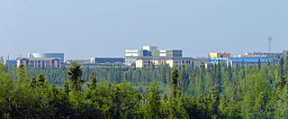
Inuvik is the only town in the Inuvik Region, and the third largest community in Canada's Northwest Territories. Located in what is sometimes called the Beaufort Delta Region, it serves as its administrative and service centre and is home to federal, territorial, and Indigenous government offices, along with the regional hospital and airport.
Aklavik is a hamlet located in the Inuvik Region of the Northwest Territories, Canada. Until 1961, with a population over 1,500, the community served as the regional administrative centre for the territorial government.
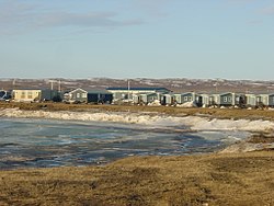
Tuktoyaktuk, or TuktuyaaqtuuqIPA: [təktujaːqtuːq], is an Inuvialuit hamlet located near the Mackenzie River delta in the Inuvik Region of the Northwest Territories, Canada, at the northern terminus of the Inuvik–Tuktoyaktuk Highway. One of six Inuvialuit communities in the Inuvialuit Settlement Region, it is commonly referred to by its first syllable, Tuk. It lies north of the Arctic Circle on the shores of the Arctic Ocean, and is the only place on the Arctic Ocean connected to the rest of Canada by road. Known as Port Brabant after British colonization, in 1950 it became the first Indigenous settlement in Canada to reclaim its traditional name.
Tsiigehtchic, officially the Charter Community of Tsiigehtchic, is a Gwich'in community located at the confluence of the Mackenzie and the Arctic Red Rivers, in the Inuvik Region of the Northwest Territories, Canada. The community was formerly known as Arctic Red River, until 1 April 1994. The Gwichya Gwich'in First Nation is located in Tsiigehtchic.
Aklak Air is an Inuvialuit owned airline based in Inuvik in Northwest Territories in Canada. It operates year-round and seasonal scheduled services, as well as charter flights throughout the western Arctic. Its main base is Inuvik Airport.
Fort Providence is a hamlet in the South Slave Region of the Northwest Territories, Canada. Located west of Great Slave Lake, it has all-weather road connections by way of the Yellowknife Highway branch off the Mackenzie Highway, and the Deh Cho Bridge opened November 30, 2012, near Fort Providence over the Mackenzie. The bridge replaced the ice bridge and ferry, enabling year-round crossing of the river.
Sachs Harbour is a hamlet located in the Inuvik Region of the Northwest Territories, Canada. Situated on the southwestern coast of Banks Island in the Inuvialuit Settlement Region, the population according to the 2021 census count was 104 people. Sachs Harbour is the only permanent settlement on Banks Island.
Ulukhaktok is a small hamlet on the west coast of Victoria Island, in the Inuvik Region of the Northwest Territories, Canada.
Fort Good Hope, is a charter community in the Sahtu Region of the Northwest Territories, Canada. It is located on a peninsula between Jackfish Creek and the east bank of the Mackenzie River, about 145 km (90 mi) northwest of Norman Wells.
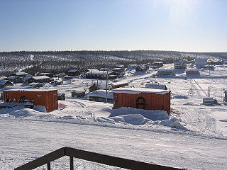
Fort McPherson is a hamlet located in the Inuvik Region of the Northwest Territories, Canada. It is located on the east bank of the Peel River and is 121 km (75 mi) south of Inuvik on the Dempster Highway.
Fort Liard is a hamlet in the Dehcho Region of the Northwest Territories, Canada. It is located 37 km (23 mi) north of the British Columbia border. It became accessible by road in 1984 with the completion of the Liard Highway.
Nahanni Butte is a "Designated Authority" in the Dehcho Region of the Northwest Territories, Canada. The community is located at the confluence of the Liard and South Nahanni Rivers in the southwestern part of the NWT.
Łutselkʼe, also spelt Łutsël Kʼé, is a "designated authority" in the North Slave Region of the Northwest Territories, Canada. The community is located on the south shore near the eastern end of Great Slave Lake and until 1 July 1992, it was known as Snowdrift, as the community lies near the mouth of the Snowdrift River.
Gamètì, officially the Tłı̨chǫ Community Government of Gamètì is a community in the North Slave Region of the Northwest Territories, Canada. Gamètì, according to the Prince of Wales Northern Heritage Centre means "rabbit-net lake". 'Gah means 'rabbit', and "mi" means net, "tì" means lake, or water. It is one of the four Tłı̨chǫ communities which form part of the Tlicho Government.
Wekweètì, officially the Tłı̨chǫ Community Government of Wekweètì is a community in the North Slave Region of the Northwest Territories, Canada. Wekweètì is a Tłı̨chǫ aboriginal community and is located 195 km (121 mi) north of Yellowknife. It has no year-round road access but does have a winter ice road connection; the majority of transportation to and from the community is through the Wekweètì Airport. Wekweètì is the closest community to the Ekati Diamond Mine on the border with Nunavut. Wekweètì is part of the Tlicho Government.
Bathurst Inlet,, is a small Inuit community located in Bathurst Inlet in the Kitikmeot Region of Nunavut, Canada.
The Inuvik Region or Beaufort Delta Region is one of five administrative regions in the Northwest Territories of Canada. According to Municipal and Community Affairs the region consists of eight communities with the regional office situated in Inuvik. Most of the communities are in the Beaufort Sea area and are a mixture of Inuit (Inuvialuit) and First Nations.
Floyd Kuptana (1964-2021) was an Inuvialuit (Inuk) artist in Canada whose work is primarily stone carvings as well as paintings and collage.
Abraham Anghik Ruben is a sculptor of partly Alaskan Native ancestry. Ruben was born south of the hamlet of Paulatuk in the Inuvik Region east of the Mackenzie River Delta in the Northwest Territories, Canada in 1951.
The Anguniaqvia niqiqyuam Marine Protected Area (MPA) is located in the Inuvialuit Settlement Region in the Northwest Territories, Canada. The MPA was established in October 2016 to support habitat for important marine species, and to help protect the marine environment adjacent to the Cape Parry Migratory Bird Sanctuary. The area is culturally important to the Inuvialuit for subsistence hunting and fishing activities. The MPA was named in honour of Nelson Green, an Inuvialuit elder from Paulatuk.