Sources: Department of Municipal and Community Affairs,[3] Prince of Wales Northern Heritage Centre,[4] Tulita profile at the Legislative Assembly[5] Canada Flight Supplement[6] ^A 2013 figure based on Edmonton = 100[7] ^B 2015 figure based on Yellowknife = 100[7]
Tulita is in an area that is forested and well south of the tree line. Permafrost underlies the area, more or less continuous in distribution. Tulita is surrounded by mountains, the latter renowned for Dall sheep, and faces the Mackenzie Mountains to the west, which has mountain goats.
History
Fort Norman originated as a Hudson's Bay Company trading post in the 19th century and has occupied a number of geographical locations prior to the settling of the modern community. A post by the name of Fort Norman occupied several locations, on the Mackenzie River, on the islands within it, on Bear River, and on the shore of Great Bear Lake near the present location of Deline. Who the name 'Norman' commemorates is unclear, but it may have been either Alexander Norman McLeod or Archibald Norman McLeod, both of whom were prominent in the northwest in the early 19th century.[8]
Between 1863 and 1869, Fort Norman was located on Great Bear Lake, a short distance west of what later became Deline (Fort Franklin), and was an HBC post commanded by Nichol Taylor. Roman Catholic missionary Émile Petitot operated a small mission here during that period. In 1869, Nichol Taylor moved Fort Norman to its present position at the confluence of the Mackenzie and Bear Rivers.[9]
Fort Norman rose to importance during the 1920s oil staking rush along the Mackenzie River, 50km (31mi) downstream of the community, where oil was developed and marketed at what became known as Norman Wells.[10] It has also become a permanent settlement for predominately SahtuDene people on whose traditional land the original trading post was built. In 1996, the name of Fort Norman was officially changed to Tulita, which translates in Dene to "where the rivers or waters meet."
In the 2021 Canadian census conducted by Statistics Canada, Tulita had a population of 396 living in 134 of its 160 total private dwellings, a change of -17% from its 2016 population of 477. With a land area of 52.28km2 (20.19sqmi), it had a population density of 7.6/km2 (19.6/sqmi) in 2021.[2]
Tulita may be reached via air year-round, and is served by Tulita Airport; Norman Wells is the regional centre and the site of origin of the majority of flights in. A winter road links Tulita to Wrigley and thence the Mackenzie Highway, and is only open in mid- to late winter. Summer access is available by barge or by canoe, from Hay River along the Mackenzie River. The NWT government is seeking federal funding to extend the Mackenzie Highway from Wrigley through Tulita to Tsiigehtchic.
Treaty Indians from the community are party to the Sahtu Agreement, which gives them shared title to 41,437 square kilometers of land in the Sahtu Region. Under the Sahtu Agreement, self-government negotiations are ongoing in all five of the region's communities, but as of 2019 only Délı̨nę has successfully reached a Final Agreement.[22]
Sternwheeler Distributor and barge at Fort Norman, 1936
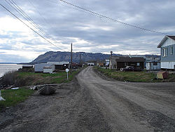
Fort Norman and Bear Rock
The Imperial Oil Company's expedition to the Fort Norman oil fields, 1921
The Imperial Oil Company's expedition to the Fort Norman oil fields, 1921
Climate
Tulita experiences a subarctic climate (Köppen: Dfc) with generally mild to warm summers and winters with averages below −20°C (−4°F). Peak snowfall occurs in the months of October and November, while rainfall is limited to the warmer months.
The outpost of Fort Norman is featured in James A. Michener's 1989 novel Journey in which the character of Lord Luton seeks information there in the winter of 1897
↑ "Tulita A". Canadian Climate Normals 1981–2010. Environment Canada. Climate ID: 2201700. Archived from the original(CSV (3069 KB)) on 13 March 2020. Retrieved 9 January 2014.
This page is based on this Wikipedia article Text is available under the CC BY-SA 4.0 license; additional terms may apply. Images, videos and audio are available under their respective licenses.

 Sternwheeler Distributor and barge at Fort Norman, 1936
 Fort Norman and Bear Rock
 The Imperial Oil Company's expedition to the Fort Norman oil fields, 1921
 The Imperial Oil Company's expedition to the Fort Norman oil fields, 1921