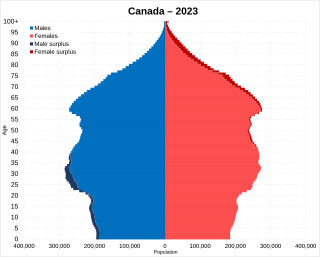
Statistics Canada conducts a country-wide census that collects demographic data every five years on the first and sixth year of each decade. The 2021 Canadian census enumerated a total population of 36,991,981, an increase of around 5.2 percent over the 2016 figure. It is estimated that Canada's population surpassed 40 million in 2023 and 41 million in 2024. Between 1990 and 2008, the population increased by 5.6 million, equivalent to 20.4 percent overall growth. The main driver of population growth is immigration, with 6.2% of the country's population being made up of temporary residents as of 2023, or about 2.5 million people. Between 2011 and May 2016, Canada's population grew by 1.7 million people, with immigrants accounting for two-thirds of the increase.

Spruce Grove is a city that is 11 km (6.8 mi) west of Edmonton, Alberta, in Canada. The city is adjacent to the Town of Stony Plain and is surrounded by Parkland County.

Leduc is a city in the province of Alberta, Canada. It is 33 km (21 mi) south of the provincial capital of Edmonton and is part of the Edmonton Metropolitan Region.

Sylvan Lake is a town in central Alberta, Canada. It is located approximately 25 kilometres (16 mi) west of the City of Red Deer along Highway 11 or Highway 11A. It is on the southeast edge of Sylvan Lake, a 15-kilometre-long (9.3 mi) freshwater lake that straddles the boundary between Red Deer County and Lacombe County.

Haines Junction is a village in Yukon, Canada. It is at Kilometre 1,632 of the Alaska Highway at its junction with the Haines Highway, hence the name of the community. According to the 2021 census, the population was 688. However, the Yukon Bureau of Statistics lists the population count for 2022 as 1,018.

Cochrane is a town in the Calgary Metropolitan Region of Alberta, Canada. The town is located 18 km (11 mi) west of the Calgary city limits along Highway 1A. Cochrane is one of the fastest-growing communities in Canada, and with a population of 32,199 in 2021, it is one of the largest towns in Alberta. It is part of Calgary's census metropolitan area and a member community of the Calgary Metropolitan Region Board (CMRB). The town is surrounded by Rocky View County.

Cold Lake is a city in east-northern Alberta, Canada and is named after the lake nearby. Canadian Forces Base Cold Lake is situated within the city's outer limits.

The Municipality of Crowsnest Pass is a specialized municipality in southwest Alberta, Canada. Within the Rocky Mountains adjacent to the eponymous Crowsnest Pass, the municipality formed as a result of the 1979 amalgamation of five municipalities – the Village of Bellevue, the Town of Blairmore, the Town of Coleman, the Village of Frank, and Improvement District No. 5, which included the Hamlet of Hillcrest and numerous other unincorporated communities.

Stony Plain is a town in the Edmonton Metropolitan Region of Alberta, Canada that is surrounded by Parkland County. It is west of Edmonton adjacent to the City of Spruce Grove and sits on Treaty 6 land.

Sexsmith is a town in northern Alberta, it is on Highway 2, 20 kilometres (12 mi) north of Grande Prairie.

Strathmore is a town located in southern Alberta, Canada that is surrounded by Wheatland County. It is along the Trans-Canada Highway approximately 50 kilometres (30 mi) east of Calgary.

Beaumont is a city adjacent to Leduc County within the Edmonton Metropolitan Region of Alberta, Canada. It is at the intersection of Highway 625 and Highway 814, adjacent to the City of Edmonton and 6.0 kilometres (3.7 mi) northeast of the City of Leduc. The Nisku Industrial Park and the Edmonton International Airport are 4.0 kilometres (2.5 mi) to the west and 8.0 kilometres (5.0 mi) to the southwest respectively.

Chestermere, originally named Chestermere Lake is a city in the Canadian province of Alberta, within Rocky View County. It is largely a commuter town of Calgary and is a member municipality of the Calgary Region. The city, which surrounds Chestermere Lake, was known as Chestermere Lake from 1977 to 1993.

Girouxville is a village in northern Alberta, Canada. It is located 58 kilometres (36 mi) south of the Town of Peace River.

Hines Creek is a village in northern Alberta, Canada. It is located 67 km west of Grimshaw and 28 km north of Fairview, along Highway 64.
The 1996 Canadian census was a detailed enumeration of the Canadian population. Census day was May 14, 1996. On that day, Statistics Canada attempted to count every person in Canada. The total population count of Canada was 28,846,761. This was a 5.7% increase over the 1991 census of 27,296,859.
According to the 2021 census, the City of Edmonton had a population of 1,010,899 residents, compared to 4,262,635 for all of Alberta, Canada. The total population of the Edmonton census metropolitan area (CMA) was 1,418,118, making it the sixth-largest CMA in Canada.
Aetna is a hamlet in southern Alberta, Canada within Cardston County, located 2 kilometres (1.2 mi) east of Highway 2, approximately 70 kilometres (43 mi) southwest of Lethbridge.

In the 2021 Census, the City of Calgary had a population of 1,306,784 residents, representing 30.7% of the 4,262,635 residents in all of Alberta, and 3.5% compared to a population of 36,991,981 in all of Canada. The total population of the Calgary census metropolitan area (CMA) was 1,481,806. Calgary is the largest city in Alberta, and the third-largest municipality and fifth-largest metropolitan area in Canada, as of 2021.