Canada is divided into 10 provinces and three territories. The majority of Canada's population is concentrated in the areas close to the Canada–US border. Its four largest provinces by area are also its most populous; together they account for 86.5 percent of the country's population. The territories account for over a third of Canada's area but are home to only 0.32 percent of its population, which skews the national population density value.

Lloydminster is a city in Canada which has the unusual geographic distinction of straddling the provincial border between Alberta and Saskatchewan. The city is incorporated by both provinces as a single city with a single municipal administration.

The Canadian Prairies is a region in Western Canada. It includes the Canadian portion of the Great Plains and the Prairie provinces, namely Alberta, Saskatchewan, and Manitoba. These provinces are partially covered by grasslands, plains, and lowlands, mostly in the southern regions. The northernmost reaches of the Canadian Prairies are less dense in population, marked by forests and more variable topography. If the region is defined to include areas only covered by prairie land, the corresponding region is known as the Interior Plains. Physical or ecological aspects of the Canadian Prairies extend to northeastern British Columbia, but that area is not included in political use of the term.
Fort Saskatchewan is a city along the North Saskatchewan River in Alberta, Canada. It is 25 kilometres (16 mi) northeast of Edmonton, the provincial capital. It is part of the Edmonton census metropolitan area and one of 24 municipalities that constitute the Edmonton Metropolitan Region Board. Its population in the 2021 federal census was 27,464.

Ukrainian Canadians are Canadian citizens of Ukrainian descent or Ukrainian-born people who immigrated to Canada.

Hungarian Canadians are persons in Canada of Hungarian ancestry. According to the 2016 Census, there are 348,085 Canadians of Hungarian ancestry. The Hungarian minority is the 24th largest ethnic group of Canada. The bulk of Hungarian immigration occurred after World War II, with the wave peaking after the 1956 Hungarian revolution against communist rule, when over 100,000 Hungarian refugees went to Canada. The Hungarian Canadian community is among the country's multiple ethnicities; Canada is one of the top five countries of the Hungarian diaspora.

Icelandic Canadians are Canadian citizens of Icelandic ancestry, or Iceland-born people who reside in Canada.
Statistics Canada conducts a national census of population and census of agriculture every five years and releases the data with a two-year lag.

Alberta has experienced a relatively high rate of growth in recent years, due in large part to its economy. Between 2003 and 2004, the province saw high birthrates, relatively high immigration, and a high rate of interprovincial migration when compared to other provinces. Approximately 81% of the population live in urban areas and only about 19% live in rural areas. The Calgary–Edmonton Corridor is the most urbanized area in Alberta and is one of Canada's four most urban regions. Many of Alberta's cities and towns have also experienced high rates of growth in recent history. From a population of 73,022 in 1901, Alberta has grown to 4,262,635 in 2021 and in the process has gone from less than 1.5% of Canada's population to 11.5%. It is the fourth most populated province in Canada. Between the 2016 and 2021 censuses, the Alberta population grew by 4.8%.
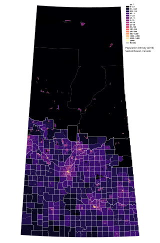
Saskatchewan is the middle province of Canada's three Prairie provinces. It has an area of 651,900 km2 (251,700 mi2) and a population of 1,132,505 (Saskatchewanians) as of 2021. Saskatchewan's population is made of 50.3% women and 49.7% men. Most of its population lives in the Southern half of the province.
The 1906 Canadian census was the first of a series of special censuses conducted by the Government of Canada, covering the rapidly expanding Northwest Provinces of Alberta, Saskatchewan, and Manitoba. These censuses were conducted every ten years from 1906 to 1946.
The economy of Saskatchewan has been associated with agriculture resulting in the moniker "Bread Basket of Canada" and Bread Basket of the World. According to the Government of Saskatchewan, approximately 95% of all items produced in Saskatchewan, depend on the basic resources available within the province. Various grains, livestock, oil and gas, potash, uranium, wood and their spin off industries fuel the economy.
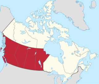
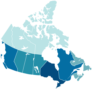
Western Canada, also referred to as the Western provinces, Canadian West, or Western provinces of Canada, and commonly known within Canada as the West, is a Canadian region that includes the four western provinces just north of the Canada–United States border namely British Columbia, Alberta, Saskatchewan and Manitoba. The people of the region are often referred to as "Western Canadians" or "Westerners", and though diverse from province to province are largely seen as being collectively distinct from other Canadians along cultural, linguistic, socioeconomic, geographic and political lines. They account for approximately 32% of Canada's total population.
The Canada 1921 census was a detailed enumeration of the Canadian population. The census count was taken as at June 1, 1921. The total population count was 8,788,483 representing a 22% increase over the 1911 census population count of 7,206,643. The 1921 census was the sixth comprehensive decennial census since Canadian Confederation on July 1, 1867. The previous census was the Northwest Provinces of Alberta, Saskatchewan, and Manitoba 1916 census and the following census was the Northwest Provinces of Alberta, Saskatchewan, and Manitoba 1926 census.

The 2016 Canadian census was an enumeration of Canadian residents, which counted a population of 35,151,728, a 5% change from its 2011 population of 33,476,688. The census, conducted by Statistics Canada, was Canada's seventh quinquennial census. The official census day was May 10, 2016. Census web access codes began arriving in the mail on May 2, 2016. The 2016 census marked the reinstatement of the mandatory long-form census, which had been dropped in favour of the voluntary National Household Survey for the 2011 census. With a response rate of 98.4%, this census is said to be the best one ever recorded since the 1666 census of New France. This census was succeeded by Canada's 2021 census.
The 1916 Canadian census was the second of a series of special censuses conducted by the Government of Canada covering the rapidly expanding Northwest Provinces of Alberta, Saskatchewan, and Manitoba. These censuses were conducted every ten years from 1906 to 1946. This census was conducted as at June 1, 1916.
The Canada 1931 census was a detailed enumeration of the Canadian population. The census count was taken as at June 1, 1931. The total population count was 10,376,379 representing a 17.9% increase over the 1911 census population count of 8,800,249. The 1931 census was the seventh comprehensive decennial census since Canadian Confederation on July 1, 1867.
The 1871 Canadian census marked the first regularly scheduled collection of national statistics of the Canadian population on April 2, 1871, as required by section 8 of the British North America Act. The constitution required a census to be taken in 1871 and every tenth year thereafter. Parliament implemented the requirements of the constitution through the Census Act of May 12, 1870. In the first census, the population of Canada was enumerated to be 3,485,761.
The Canada 1941 census was a detailed enumeration of the Canadian population. The total population count was 11,506,655, representing a 10.9% increase over the 1931 census population count of 10,376,786. The 1941 census was the eighth comprehensive decennial census since Canadian Confederation on July 1, 1867. The previous census was the Northwest Provinces of Alberta, Saskatchewan, and Manitoba 1936 census and the following census was the Northwest Provinces of Alberta, Saskatchewan, and Manitoba 1946 census.
The 1901 Canadian census was a detailed enumeration of the Canadian population. The census was started on June 1, 1901. All reports had been received by February 26, 1902. The total population count of Canada was 5,371,315. This was an increase of 11% over the 1891 census of 4,833,239.