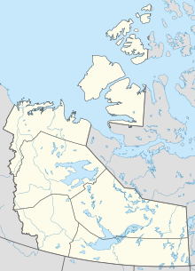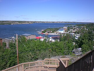
Yellowknife is the capital, largest community, and only city in the Northwest Territories, Canada. It is on the northern shore of Great Slave Lake, about 400 km (250 mi) south of the Arctic Circle, on the west side of Yellowknife Bay near the outlet of the Yellowknife River.

The Diavik Diamond Mine is a diamond mine in the North Slave Region of the Northwest Territories, Canada, about 300 km (190 mi) northeast of Yellowknife.
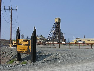
The Giant Mine was a gold mine located on the Ingraham Trail, 5 km (3.1 mi) north of Yellowknife, Northwest Territories. Giant Mine was within the Kam Group, a part of the Yellowknife greenstone belt. Gold was discovered on the property and mineral claims staked in 1935 by Johnny Baker, but the true extent of the gold deposits was not known until 1944, when a massive gold-bearing shear zone was uncovered beneath the drift-filled Baker Creek Valley.
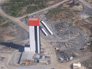
The Con Mine (1938-2003) was the first gold mine developed in the Northwest Territories, Canada, just south of Yellowknife. The property was staked by Consolidated Mining and Smelting Company of Canada (Cominco) in September 1935 in response to the discovery of visible gold nearby; the name "Con" is an abbreviation of "Consolidated". The advent of winter prevented any prospecting from being conducted, but work in the summer of 1936 led to the discovery of numerous gold veins. The Con Mine entered production in 1938 and ceased operations in 2003. It has produced over 5,000,000 ozt (160,000 kg) of gold from 12,195,585 tons of ore processed. The mine was over 6,000 ft (1,800 m) deep.
The Colomac Mine was a privately owned and operated open pit gold mine located 200 km northwest of Yellowknife in the Northwest Territories in Canada. The Colomac mine operated between 1990–1992, and 1994–1997. It was operated by Neptune Resources Limited that had little success in making a profit during its operation. In 1994, the mine had reopened under Royal Oak Mines Inc. Both Neptune Resources and Royal Oak Mines where both owned and operated by Peggy Witte. Due to low gold prices and high cost of mining, Royal Oak Mines was forced into bankruptcy. The Federal Government of Canada became owners of the mine, along with the related environmental issues. A major cleanup effort was completed to prevent the mine from polluting the environment. On January 26, 2012, Nighthawk Gold Corporation completed an agreement to acquire 100% of the mineral claims and leases of the former producing Colomac Gold Mine and surrounding mineral leases, from then Aboriginal Affairs and Northern Development Canada (AANDC) now Crown Indigenous Relations and Northern Affairs Canada (CIRNAC). The Colomac Property lies within the central portion of Nighthawk Gold’s 930 square kilometre property. Nighthawk Gold has since been responsibly exploring and advancing the Colomac Gold Project with the goal to restart gold mining operations in the future, assuming positive economics and the receipt of operating permits.
The Rayrock Mine was a uranium producing venture in the Northwest Territories, Canada. It is located on the south side of Maryleer Lake and the north shore of Fault Lake, 169 kilometers northwest of Yellowknife and 74 kilometres northwest of Rae. Radioactive deposits were originally staked in 1948 and then restaked in 1950. American Yellowknife Mines Limited explored the site with detailed Geiger surveys and extensive trenching in the early 1950s. In 1954 exploration work included over 10,000 feet (3,000 m) of surface diamond drilling, and the company was reorganized as Rayrock Mines Limited.
The Ptarmigan and Tom Mine were gold producers located in the Northwest Territories, Canada at Yellowknife. The property was staked by prospectors in 1936 and acquired by Cominco in 1938. The mine first produced between 1941 and 1942 but closed due to wartime restrictions. The old property was demolished in 1969–1970. A new company, Treminco Resources Limited, reopened the workings in 1985 and production from the Tom portal began in 1986 with material being trucked to Giant Mine. The old Ptarmigan mine shaft was dewatered and production began in 1987. A new mill was built at the property and was operational in July 1989. Low gold prices forced the company to close the mines in 1997. Total gold production has been approximately 120,000 troy ounces.
Negus Mine was a gold producer at Yellowknife, Northwest Territories, Canada, from 1939 to 1952. It produced 255,807 troy ounces (7,956.5 kg) of gold from 490,808 tons of ore milled. The underground workings were acquired by adjacent Con Mine in 1953 and were used for ventilation purposes until Con Mine closed in 2003.
The Burwash Mine was a small gold property discovered in the fall of 1934 by Johnny Baker and Hugh Muir at Yellowknife Bay, Northwest Territories. The town of Yellowknife did not exist yet at that point, but the discovery of gold at Burwash was the catalyst that brought more gold prospectors into the region in 1935 and 1936. A short shaft was sunk in 1935–1936 at Burwash, and in the summer of 1935 a 16-ton bulk sample of ore was shipped to Trail, British Columbia for processing, yielding 200 troy ounces (6.2 kg) of gold. The mine did not become a substantial producer and it is believed the gold vein was mined out.
The Thompson-Lundmark Mine was a gold producer in the periods 1941–1943 and 1947–1949, near Yellowknife, Northwest Territories. Gold was discovered here in 1938 by Fred W. Thompson and Roy Lundmark, who staked 46 claims which were incorporated into the mine. Underground and shaft work began in 1939. The mine processed 133,989 tons of ore to produce 70,339 troy ounces (2,187.8 kg) of gold and 13,782 troy ounces (428.7 kg) of silver. The abandoned site was destroyed by forest fires during 1998.
The Camlaren Mine was a small gold mine 80 km (50 mi) north-east of Yellowknife, Northwest Territories, Canada at Gordon Lake. It consists of a property totaling about 981 hectares. The two claims that make up the property were staked in 1936 by prospectors Don Cameron and the Mclaren brothers and developed with two shafts during 1937–1938. The name "Camlaren" is a portmanteau of Cameron and McLaren. Conditions attributed to World War II halted development at Camlaren in 1939.

The Ruth Mine was a small gold producer about 65 kilometres (40 mi) east of Yellowknife, Northwest Territories. It operated briefly during 1942 and resumed operations in 1959, extracting to date 550 troy ounces of gold.
The Pine Point Mine is located on the south shore of Great Slave Lake between Hay River to the west and Fort Resolution to the east, in the Northwest Territories of Canada. It produced lead and zinc ores from a Mississippi Valley Type deposit between 1964 and 1988. Most of the mining was done by open-pit methods. The town of Pine Point was built by the mining company, Cominco, and when the mine closed the town was abandoned and demolished.
The Salmita Mine was a gold producer in the Northwest Territories, Canada during 1983 to 1987. The deposit was first discovered in 1945 and underground exploration was carried out in 1951–1952. It was reactivated for exploration by Giant Yellowknife Mines Limited in 1975 and entered production in 1983. They used the old camp and milling plant of the abandoned Tundra Mine, located a few kilometres to the south. The mine produced 179,906 troy ounces (5,595.7 kg) of gold from the milling of 238,177 tons of ore. The area is now owned by Seabridge Gold.

The Mackenzie Mountains are a Canadian mountain range forming part of the Yukon-Northwest Territories boundary between the Liard and Peel rivers. The range is named in honour of Canada's second prime minister, Alexander Mackenzie. Nahanni National Park Reserve and Nááts'ihch'oh National Park Reserve are in the Mackenzie Mountains.
Goldcorp Inc. was a gold production company headquartered in Vancouver, British Columbia, Canada. The company stood among the largest gold producers in the world, employed about 15,800 people worldwide, engaged in gold mining and related activities including exploration, extraction, processing and reclamation. Goldcorp’s operating assets included eleven mines in North and South America.

Tibbitt to Contwoyto Winter Road is an annual ice road first built in 1982 to service mines and exploration activities in the Northwest Territories and Nunavut in Northern Canada. Between 400 and 600 km long, the road is said to be the world's longest heavy haul ice road and operates for eight to ten weeks starting in the last week of January. Most of the road (85%–87%) is built over frozen lakes, 495 km (308 mi), with the remaining 73 km (45 mi) built on over 64 land portages between lakes.
Gold mining in Alaska, a state of the United States, has been a major industry and impetus for exploration and settlement since a few years after the United States acquired the territory in 1867 from the Russian Empire. Russian explorers discovered placer gold in the Kenai River in 1848, but no gold was produced. Gold mining started in 1870 from placers southeast of Juneau, Alaska.
This timeline of Yellowknife history summarises key events in the history of Yellowknife, a city in the Northwest Territories, Canada.
Seabridge Gold is a Canadian company that is pursuing the development of the Kerr Sulphurets Mitchell ("KSM") gold-silver-molybdenum-copper mine in northwest British Columbia. Headquartered in Toronto, the company is listed on the Toronto Stock Exchange and the New York Stock Exchange. The company was founded in 1979 as a mining company but, in 1999, re-organized to pursue exploration and development of gold deposits with a new board of directors and new management team. Of the mineral properties acquired between 2000 and 2002, the KSM project emerged as its core asset. The project advanced through its preliminary feasibility study and received its environmental assessment approval in 2014. The Company has completed new development plans and is actively looking for a partner to co-develop the project. KSM is one of the world’s largest gold/copper projects as measured by mineral reserves and resources. Seabridge also owns several other mineral properties, including the Courageous Lake project in Northwest Territories, the Iskut project in northwest BC, the Snowstorm project in Nevada and the 3 Aces project in Canada’s Yukon.