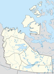
The Northwest Territories is a federal territory of Canada. At a land area of approximately 1,144,000 km2 (442,000 sq mi) and a 2016 census population of 41,790, it is the second-largest and the most populous of the three territories in Northern Canada. Its estimated population as of 2023 is 45,668. Yellowknife is the capital, most populous community, and only city in the territory; its population was 19,569 as of the 2016 census. It became the territorial capital in 1967, following recommendations by the Carrothers Commission.
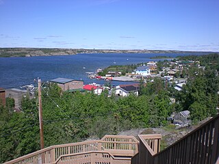
Yellowknife is the capital, largest community, and only city in the Northwest Territories, Canada. It is on the northern shore of Great Slave Lake, about 400 km (250 mi) south of the Arctic Circle, on the west side of Yellowknife Bay near the outlet of the Yellowknife River.
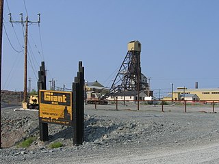
The Giant Mine was a gold mine located on the Ingraham Trail, 5 km (3.1 mi) north of Yellowknife, Northwest Territories. Giant Mine was within the Kam Group, a part of the Yellowknife greenstone belt. Gold was discovered on the property and mineral claims staked in 1935 by Johnny Baker, but the true extent of the gold deposits was not known until 1944, when a massive gold-bearing shear zone was uncovered beneath the drift-filled Baker Creek Valley.
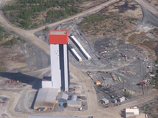
The Con Mine (1938-2003) was the first gold mine developed in the Northwest Territories, Canada, just south of Yellowknife. The property was staked by Consolidated Mining and Smelting Company of Canada (Cominco) in September 1935 in response to the discovery of visible gold nearby; the name "Con" is an abbreviation of "Consolidated". The advent of winter prevented any prospecting from being conducted, but work in the summer of 1936 led to the discovery of numerous gold veins. The Con Mine entered production in 1938 and ceased operations in 2003. It has produced over 5,000,000 ozt (160,000 kg) of gold from 12,195,585 tons of ore processed. The mine was over 6,000 ft (1,800 m) deep.
The Ptarmigan and Tom Mine were gold producers located in the Northwest Territories, Canada at Yellowknife. The property was staked by prospectors in 1936 and acquired by Cominco in 1938. The mine first produced between 1941 and 1942 but closed due to wartime restrictions. The old property was demolished in 1969–1970. A new company, Treminco Resources Limited, reopened the workings in 1985 and production from the Tom portal began in 1986 with material being trucked to Giant Mine. The old Ptarmigan mine shaft was dewatered and production began in 1987. A new mill was built at the property and was operational in July 1989. Low gold prices forced the company to close the mines in 1997. Total gold production has been approximately 120,000 troy ounces.
Negus Mine was a gold producer at Yellowknife, Northwest Territories, Canada, from 1939 to 1952. It produced 255,807 troy ounces (7,956.5 kg) of gold from 490,808 tons of ore milled. The underground workings were acquired by adjacent Con Mine in 1953 and were used for ventilation purposes until Con Mine closed in 2003.
The Thompson-Lundmark Mine was a gold producer in the periods 1941–1943 and 1947–1949, near Yellowknife, Northwest Territories. Gold was discovered here in 1938 by Fred W. Thompson and Roy Lundmark, who staked 46 claims which were incorporated into the mine. Underground and shaft work began in 1939. The mine processed 133,989 tons of ore to produce 70,339 troy ounces (2,187.8 kg) of gold and 13,782 troy ounces (428.7 kg) of silver. The abandoned site was destroyed by forest fires during 1998.
The Discovery Mine was a gold mine 84 kilometers northeast of Yellowknife, Northwest Territories that operated between 1950 and 1969. Gold was discovered here by Alfred Giauque in 1944. A complete townsite, on Giauque Lake, was established by the company to house workers and their families. The mine produced one million troy ounces (31,000 kg) of gold from one million tons of ore. The abandoned townsite, not accessible by road, was demolished in 2005.
The Camlaren Mine was a small gold mine 80 km (50 mi) north-east of Yellowknife, Northwest Territories, Canada at Gordon Lake. It consists of a property totaling about 981 hectares. The two claims that make up the property were staked in 1936 by prospectors Don Cameron and the Mclaren brothers and developed with two shafts during 1937–1938. The name "Camlaren" is a portmanteau of Cameron and McLaren. Conditions attributed to World War II halted development at Camlaren in 1939.
The Beaulieu Mine was a post-World War II gold mining operation near Yellowknife, Northwest Territories. It entered production in October 1947 but by the end of November only 7 ounces of rough gold were recovered. Additional gold was recovered during 1948, but the mine recovered only 30 troy ounces (930 g) of fine gold altogether. The operation folded in chaos and bankruptcy.
The Outpost Island Mine was a gold and tungsten producer 94 kilometres southeast of Yellowknife, Northwest Territories on an island of Great Slave Lake. Gold was discovered here in 1935 by prospectors, and some development was undertaken in 1936–1938. Tungsten ores became valuable during World War II, so the owners investigated the tungsten possibilities of the mine. It produced small amounts of gold, copper, and tungsten during 1941–1942, and then again in 1951-1952 during the Korean War. It was a small deposit and was not considered economic because of unpredictable tungsten market prices in the 1950s.

The Ruth Mine was a small gold producer about 65 kilometres (40 mi) east of Yellowknife, Northwest Territories. It operated briefly during 1942 and resumed operations in 1959, extracting to date 550 troy ounces of gold.

The history of the Northwest Territories covers the period from thousands of years ago to the present day. Prior to European colonization, the lands that encompass present-day Northwest Territories were inhabited for millennia by several First Nations. European explorers and fur traders began to explore the region since the late-16th century. By the 17th century, the British laid claim to both the North-Western Territory and Rupert's Land; and granted the Hudson's Bay Company a commercial fur trade monopoly over the latter region.

The Yellowknife Catholic School Board is the school board responsible for École St. Joseph School, Weledeh Catholic School, École St. Patrick High School and the Kimberlite Career & Technical Centre in Yellowknife, Northwest Territories, Canada.

The Yellowknife Education District No. 1 is the public school board in Yellowknife, Northwest Territories. The district, then called Yellowknife School District No. 1, was created 1 October 1939 by Charles Camsell who was Commissioner of the Northwest Territories.
News/North is a newspaper based in Yellowknife, Northwest Territories, with offices in Fort Smith, Hay River, Fort Providence and Norman Wells, Northwest Territories, as well as Iqaluit and Rankin Inlet, Nunavut, and owned by Northern News Services. The newspaper is printed in two separate editions, Northwest Territories News/North and Nunavut News/North that reports on news throughout the NWT and Nunavut. Although some features are identical in the two papers, the majority of the articles reflect the territory they are intended for. The Nunavut News/North features several articles translated into Inuktitut and printed in syllabics. A Monday edition is printed weekly, with a different front page substituted on the Northwest Territories News/North for distribution in Yellowknife.
This timeline of Yellowknife history summarises key events in the history of Yellowknife, a city in the Northwest Territories, Canada.

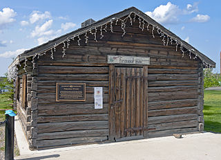
The Bank of Toronto is a historic cabin located in Old Town, Yellowknife, Northwest Territories, Canada. The log cabin was constructed in 1939 by John Stakson, an expert log builder, in the commercial district of the Yellowknife community for use as a residence. In October 1944, the Bank of Toronto purchased the cabin and opened a new bank for the community, joining the Bank of Commerce. The bank arrived in Yellowknife in response to new financial activity brought about by the intersection of gold in shear zones at Giant Mine and the resulting staking spree around the region. As the gold rush ended, the volume of business was insufficient to keep the bank profitable, and the Bank of Toronto closed this branch in August 1951.
Ranney Hill is a rock outcrop approximately 10 kilometers north of Yellowknife, the capital city of the Northwest Territories of Canada. At 682 ft / 208 m. high, it is one of three visible outcrops that can be seen north of the city. It is an anomaly rising from the relatively flat Canadian Shield.