
Events from the year 1771 in Canada.
Inuinnaqtun, is an Inuit language. It is spoken in the central Canadian Arctic. It is related very closely to Inuktitut, and some scholars, such as Richard Condon, believe that Inuinnaqtun is more appropriately classified as a dialect of Inuktitut. The government of Nunavut recognises Inuinnaqtun as an official language in addition to Inuktitut, and together sometimes referred to as Inuktut. It is spoken in the Northwest Territories as well and is recognised as an official language of the territory in addition to Inuvialuktun and Inuktitut.

The Coppermine River is a river in the North Slave and Kitikmeot regions of the Northwest Territories and Nunavut in Canada. It is 845 kilometres (525 mi) long. It rises in Lac de Gras, a small lake near Great Slave Lake, and flows generally north to Coronation Gulf, an arm of the Arctic Ocean. The river freezes in winter but may still flow under the ice.
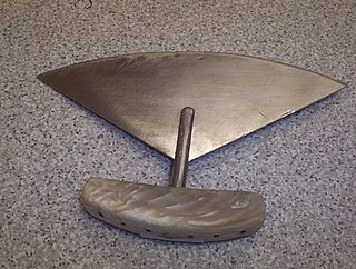
An ulu is an all-purpose knife traditionally used by Inuit, Iñupiat, Yupik, and Aleut women. It is used in applications as diverse as skinning and cleaning animals, cutting a child's hair, cutting food, and sometimes even trimming blocks of snow and ice used to build an igloo.
Kangiryuarmiutun, is a dialect of Inuit language spoken in Ulukhaktok, Northwest Territories, Canada by the Kangiryuarmiut, a Copper Inuit group. The dialect is part of the Inuvialuktun language. The people of Ulukhaktok prefer to think of it as Inuinnaqtun and it is essentially the same.

Blonde Eskimos or Blond Eskimos is a term first applied in accounts of sightings of, and encounters with, light-haired Inuit peoples of Northern Canada from the early 20th century, particularly around the Coronation Gulf between mainland Canada and Victoria Island. Sightings of light-haired natives of the Arctic have been mentioned in written accounts as far back as the 17th century.

Ulukhaktok and known until 1 April 2006 as Holman or Holman Island) is a small hamlet on the west coast of Victoria Island, in the Inuvik Region of the Northwest Territories, Canada.
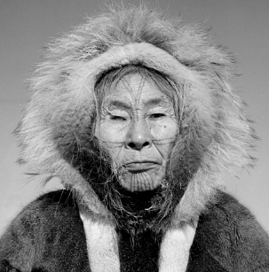
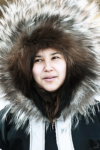
Helen Kalvak, (Kalvakadlak) was a Copper Inuk graphic artist from Ulukhaktok, Northwest Territories, Canada.

Nunavut is the largest and northernmost territory of Canada. It was separated officially from the Northwest Territories on April 1, 1999, via the Nunavut Act and the Nunavut Land Claims Agreement Act, which provided this territory to the Inuit for self-government. The boundaries had been drawn in 1993. The creation of Nunavut resulted in the first major change to Canada's political map in half a century since the province of Newfoundland was admitted in 1949.
The Bloody Falls massacre was an incident that took place during Hudson's Bay Company employee Samuel Hearne's exploration of the Coppermine River for copper deposits near modern-day Kugluktuk, Nunavut, Canada on 17 July 1771. Hearne's original travelogue is now lost, and the narrative that became famous was published after Hearne's death with substantial editorializing. The narrative states that Chipewyan and "Copper Indian" Dene men led by Hearne's guide and companion Matonabbee attacked a group of Copper Inuit camped by rapids approximately 15 km (9.3 mi) upstream from the mouth of the Coppermine River.

Kivallirmiut, also called the Caribou Inuit, barren-ground caribou hunters, are Inuit who live west of Hudson Bay in Kivalliq Region, Nunavut, between 61° and 65° N and 90° and 102° W in Northern Canada.

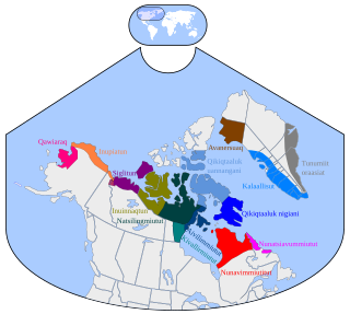
Copper Inuit, also known as Inuinnait and Kitlinermiut, are a Canadian Inuit group who live north of the tree line, in what is now the Kitikmeot Region of Nunavut and in the Inuvialuit Settlement Region in the Inuvik Region of the Northwest Territories. Most of them historically lived in the area around Coronation Gulf, on Victoria Island, and southern Banks Island.
Denmark Bay is an Arctic waterway in Kitikmeot Region, Nunavut, Canada. It is located in western M'Clintock Channel, off the eastern coast of Victoria Island. It is separated from Homan Bay by a peninsula with a narrow isthmus.
Cape Bexley is a headland in the northern Canadian territory of Nunavut. It is located on the mainland, on the south shore of Dolphin and Union Strait, and bounded on the south by Souths Bay. It was named after Nicholas Vansittart, 1st Baron Bexley.

The Kangiryuarmiut are an Inuvialuit group, culturally and historically related to the Copper Inuit. They were historically located on Victoria Island in the areas of Prince Albert Sound, Cape Baring, and central Victoria island. They often travelled seasonally around their traditional territory including to Banks Island, both south to Nelson Head and as far north as Mercy Bay to collect raw materials from the wreck of HMS Investigator. Archaeologists have also found many sites left by Kangiryuarmiut and their ancestors in what is now Aulavik National Park. Today, many Kangiryurmiut still live on Victoria Island, in the hamlet of Uluhaktok, now within the Inuvialuit Settlement Region.
Kangiryuatjagmiut were a Copper Inuit subgroup. They lived around Minto Inlet, and between Minto inlet and Walker Bay.
The Kugaryuak River is located in the Canadian Arctic territory of Nunavut in the southwest Kitikmeot Region. It forks into two entities, the Western Kugaryuak and the Eastern Kugaryuak and flows into Coronation Gulf.
The Canadian Arctic Expedition 1913–1916 was a scientific expedition in the Arctic Circle organized and led by Vilhjalmur Stefansson. The expedition was originally to be sponsored by the (US) National Geographic Society and the American Museum of Natural History. Canada took over the sponsorship because of the potential for discovery of new land and Stefansson, who though born in Canada was now an American, re-established his Canadian citizenship. The expedition was divided into a Northern Party led by Stefansson, and a Southern Party led by R M. Anderson.
Fort Collinson was a trading post operated by the Hudson's Bay Company located on Victoria Island in the Northwest Territories, Canada. It is situated on the Prince Albert Peninsula on the north side of Walker Bay, just north of Minto Inlet.
There is a long historical tradition of research on Inuit clothing across many fields. Since Europeans first made contact with the Inuit in the 16th century, documentation and research on Inuit clothing has included artistic depictions, academic writing, studies of effectiveness, and museum collections. Historically, European images of Inuit were sourced from the clothing worn by Inuit who travelled to Europe, clothing brought to museums by explorers, and from written accounts of travels to the Arctic.
