
The Northwest Passage (NWP) is the sea lane between the Atlantic and Pacific oceans through the Arctic Ocean, along the northern coast of North America via waterways through the Arctic Archipelago of Canada. The eastern route along the Arctic coasts of Norway and Siberia is accordingly called the Northeast Passage (NEP). The various islands of the archipelago are separated from one another and from Mainland Canada by a series of Arctic waterways collectively known as the Northwest Passages, Northwestern Passages or the Canadian Internal Waters.

Victoria Island is a large island in the Arctic Archipelago that straddles the boundary between Nunavut and the Northwest Territories of Canada. It is the eighth-largest island in the world, and at 217,291 km2 (83,897 sq mi)1 in area, it is Canada's second-largest island. It is nearly double the size of Newfoundland (111,390 km2 [43,010 sq mi]), and is slightly larger than the island of Great Britain (209,331 km2 [80,823 sq mi]) but smaller than Honshu (225,800 km2 [87,200 sq mi]). The western third of the island lies in the Inuvik Region of the Northwest Territories; the remainder is part of Nunavut's Kitikmeot Region. The population of 2,168 is divided between two settlements, the larger of which is Cambridge Bay (Nunavut) and the other Ulukhaktok.
Banks Island is one of the larger members of the Arctic Archipelago. Situated in the Inuvik Region, and part of the Inuvialuit Settlement Region, of the Northwest Territories, it is separated from Victoria Island to its east by the Prince of Wales Strait and from the mainland by Amundsen Gulf to its south. The Beaufort Sea lies to its west, and to its northeast M'Clure Strait separates the island from Prince Patrick Island and Melville Island.

Northern Canada, colloquially the North or the Territories, is the vast northernmost region of Canada, variously defined by geography and politics. Politically, the term refers to the three territories of Canada: Yukon, Northwest Territories and Nunavut. This area covers about 48 per cent of Canada's total land area, but has less than 0.5 per cent of Canada's population.

Mansel Island, a member of the Arctic Archipelago, is an uninhabited island in Qikiqtaaluk Region, Nunavut. It is located in Hudson Bay off of Quebec's Ungava Peninsula. At 3,180 km2 (1,230 sq mi) in size, it is the 159th largest island in the world, and Canada's 28th largest island. Its topography features a gently undulating limestone lowland with elevations not exceeding 100 m.

A member of the Arctic Archipelago, Prince Patrick Island is the westernmost of the Queen Elizabeth Islands in the Northwest Territories of Canada, lying northwest of Melville Island. The area of Prince Patrick Island is 15,848 km2 (6,119 sq mi), making it the 55th largest island in the world and Canada's 14th largest island. It has historically been icebound all year, making it one of the least accessible parts of Canada. Located at the entrance of the M'Clure Strait, Prince Patrick Island is uninhabited.

Henry Asbjørn Larsen was a Norwegian-Canadian Arctic explorer. Larsen was born on a small island, Herføl, south of Fredrikstad in Norway. Like his hero, Roald Amundsen, he became a seaman. Larsen immigrated to Canada, and became a British subject in 1927. In 1928, he joined the Royal Canadian Mounted Police (RCMP).

Aulavik National Park ; from the Inuvialuktun for "place where people travel") is a national park located on Banks Island in the Northwest Territories of Canada. It is known for its access to the Thomsen River, one of the most northerly navigable rivers in North America. The park is a fly-in park, and protects approximately 12,274 square kilometres (4,739 sq mi) of Arctic Lowlands at the northern end of the island. The most practical way to visit the park is to charter a plane, and currently the park has four landing sites. Aulavik is considered a polar desert and often experiences high winds. Precipitation for the park is approximately 300 mm (12 in) per year. In the southern regions of the park a sparsely vegetated upland plateau reaches a height of 450 m (1,480 ft) above sea level.

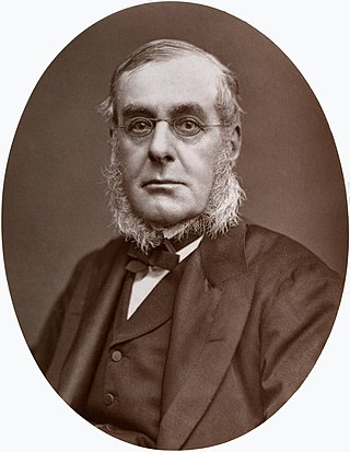
The M'Clure Strait is a strait on the edge of the Canadian Northwest Territories. It forms the northwestern end of the Parry Channel which extends east all the way to Baffin Bay and is thus a possible route for the Northwest Passage. The strait was named for Robert McClure, an Irish Arctic explorer serving in the Royal Navy. He was the first man to traverse the North-West Passage.

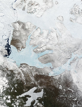
The Prince of Wales Strait is a strait in the Northwest Territories of Canada separating Banks Island to the northwest from Victoria Island to the southeast. It extends from Viscount Melville Sound in the northeast to Amundsen Gulf in the southwest. From late winter, it is filled by ice that usually does not break up until August, if at all. Its namesake, Prince of Wales Island, lies over 200 mi (320 km) to the east.

Sachs Harbour is a hamlet located in the Inuvik Region of the Northwest Territories, Canada. Situated on the southwestern coast of Banks Island in the Inuvialuit Settlement Region, the population according to the 2021 census count was 104 people. Sachs Harbour is the only permanent settlement on Banks Island.

The British Arctic Territories were a region of British North America, composed of islands to the north of continental North America. They are now known as the Arctic Archipelago.
Admiral Sir Richard Collinson was an English naval officer and explorer of the Northwest Passage.

Franklin's lost expedition was a failed British voyage of Arctic exploration led by Captain Sir John Franklin that departed England in 1845 aboard two ships, HMS Erebus and HMS Terror, and was assigned to traverse the last unnavigated sections of the Northwest Passage in the Canadian Arctic and to record magnetic data to help determine whether a better understanding could aid navigation. The expedition met with disaster after both ships and their crews, a total of 129 officers and men, became icebound in Victoria Strait near King William Island in what is today the Canadian territory of Nunavut. After being icebound for more than a year Erebus and Terror were abandoned in April 1848, by which point two dozen men, including Franklin, had died. The survivors, now led by Franklin's second-in-command, Francis Crozier, and Erebus's captain, James Fitzjames, set out for the Canadian mainland and disappeared, presumably having perished.

The Parry Channel is a natural waterway through the central Canadian Arctic Archipelago. Its eastern two-thirds lie in the territory of Nunavut, while its western third lies in the Northwest Territories. It runs east to west, connecting Baffin Bay in the east with the Beaufort Sea in the west. Its eastern end is the only practical entrance to the Northwest Passage. Its western end would be a natural exit from the archipelago were it not filled with ice. The channel separates the Queen Elizabeth Islands to the north from the rest of Nunavut.

Copper Inuit, also known as Inuinnait and Kitlinermiut, are a Canadian Inuit group who live north of the tree line, in what is now the Kitikmeot Region of Nunavut and in the Inuvialuit Settlement Region in the Inuvik Region of the Northwest Territories. Most of them historically lived in the area around Coronation Gulf, on Victoria Island, and southern Banks Island.

HMS Investigator was a merchant ship purchased in 1848 to search for Sir John Franklin's ill-fated Northwest Passage expedition. She made two voyages to the Arctic and had to be abandoned in 1853, after becoming trapped in the pack ice.

Mercy Bay is a Canadian Arctic waterway in the Northwest Territories. It is a southern arm of M'Clure Strait on northeast Banks Island. The mouth of Castel Bay is less than 20 km (12 mi) to the west. These bays are a part of Aulavik National Park.
The Kellett Strait is a natural waterway through the central Canadian Arctic Archipelago in the Northwest Territories of Canada. It separates Eglinton Island and Melville Island. It opens into the McClure Strait to the south, and the Fitzwilliam Strait to the north.

The McClure Arctic expedition, one of many attempts to find the missing Franklin expedition, was significant for being the first to successfully discover and transit the Northwest Passage, which it accomplished by both boat and sledging.
