Horn River

Last updated
Horn River
Common loon (18497988623).jpg
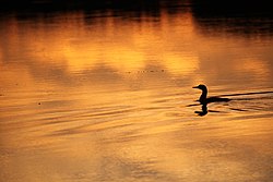
A common loon on the Horn River at sunrise
Location
Country Canada
Territory Northwest Territories
Physical characteristics
Source 
  coordinates 62°44′N119°38′W / 62.73°N 119.63°W / 62.73; -119.63 (Horn River origin)
  elevation240 m (790 ft)
Mouth  
  location
Mackenzie River
  coordinates
61°28′36″N118°04′51″W / 61.47665°N 118.08075°W / 61.47665; -118.08075 (Horn River mouth)
  elevation
150 m (490 ft)

The Horn River is a river in the Northwest Territories of Canada. It is a major tributary of the Mackenzie River.

Contents

The river gives the name to the Horn River Formation, a shale deposit of the Western Canadian Sedimentary Basin. The Horn River Basin refers to the extent of the Horn River Formation in the subsurface, and is not defined by the Horn River watershed.

Course

The river originates south of the Great Bear Lake. It flows south-east through a series of rapids north of the Horn Plateau, then has a meandered flow. Fawn Lake is a complex wetland formed along the middle course of the Horn River, and is followed downstream by the Second Lake. The river turns south-west, where the Mink Lake is formed along its course. The Laferte River also flows into the Mink Lake. Horn River then flows south, and it receives the waters of the Bluefish River before it empties into the Mackenzie River, 100 kilometres (62 mi) downstream from the Great Slave Lake), immediately upstream from Mills Lake, at an elevation of 150 metres (490 ft).

The arch made by the river defines the Horn Plateau, a flat elevated area that rises up to 820 metres (2,690 ft)) to the north and east, while the south is defined by the Mackenzie River east of Fort Simpson.

Tributaries

From origin to mouth, the Horn River receives:

Origin 62°44′N119°38′W / 62.73°N 119.63°W / 62.73; -119.63 (Origin)
Benner Creek 62°17′16″N117°47′29″W / 62.28786°N 117.79134°W / 62.28786; -117.79134 (Benner Creek)
Fawn Lake 62°09′20″N117°35′19″W / 62.15557°N 117.58850°W / 62.15557; -117.58850 (Fawn Lake)
Second Lake 62°07′34″N117°27′12″W / 62.12602°N 117.45326°W / 62.12602; -117.45326 (Second Lake)
Mink Lake 61°54′37″N117°37′55″W / 61.91024°N 117.63208°W / 61.91024; -117.63208 (Mink Lake)
Laferte River 61°52′38″N117°43′34″W / 61.87723°N 117.72606°W / 61.87723; -117.72606 (Laferte River)
Bluefish River 61°30′55″N117°57′42″W / 61.51520°N 117.96175°W / 61.51520; -117.96175 (Bluefish River)
Mackenzie River 61°28′32″N118°04′56″W / 61.47546°N 118.08229°W / 61.47546; -118.08229 (Mackenzie River)

See also

Map all coordinates using: OpenStreetMap

Related Research Articles

<span class="mw-page-title-main">Geography of Africa</span> Geographical features of Africa

Africa is a continent comprising 63 political territories, representing the largest of the great southward projections from the main mass of Earth's surface. Within its regular outline, it comprises an area of 30,368,609 km2 (11,725,385 sq mi), excluding adjacent islands. Its highest mountain is Mount Kilimanjaro; its largest lake is Lake Victoria.

<span class="mw-page-title-main">Continental Divide of the Americas</span> Principal hydrological divide of North and South America

The Continental Divide of the Americas is the principal, and largely mountainous, hydrological divide of the Americas. The Continental Divide extends from the Bering Strait to the Strait of Magellan, and separates the watersheds that drain into the Pacific Ocean from those river systems that drain into the Atlantic and Arctic Ocean, including those that drain into the Gulf of Mexico, the Caribbean Sea, and Hudson Bay.

<span class="mw-page-title-main">Athabasca River</span> Canadian river in Alberta

The Athabasca River is a river in Alberta, Canada, which originates at the Columbia Icefield in Jasper National Park and flows more than 1,231 km (765 mi) before emptying into Lake Athabasca. Much of the land along its banks is protected in national and provincial parks, and the river is designated a Canadian Heritage River for its historical and cultural importance. The scenic Athabasca Falls is located about 30 km (19 mi) upstream from Jasper.

<span class="mw-page-title-main">Mackenzie River</span> Largest river system in Canada

The Mackenzie River is a river in the Canadian boreal forest. It forms, along with the Slave, Peace, and Finlay, the longest river system in Canada, and includes the second largest drainage basin of any North American river after the Mississippi.

<span class="mw-page-title-main">Stikine River</span> River in British Columbia and Alaska

The Stikine River is a major river in northern British Columbia (BC), Canada and southeastern Alaska in the United States. It drains a large, remote upland area known as the Stikine Country east of the Coast Mountains. Flowing west and south for 610 kilometres (379 mi), it empties into various straits of the Inside Passage near Wrangell, Alaska. About 90 percent of the river's length and 95 percent of its drainage basin are in Canada. Considered one of the last truly wild large rivers in BC, the Stikine flows through a variety of landscapes including boreal forest, steep canyons and wide glacial valleys.

<span class="mw-page-title-main">Liard River</span> River in Canada

The Liard River of the North American boreal forest flows through Yukon, British Columbia and the Northwest Territories, Canada. Rising in the Saint Cyr Range of the Pelly Mountains in southeastern Yukon, it flows 1,115 km (693 mi) southeast through British Columbia, marking the northern end of the Rocky Mountains and then curving northeast back into Yukon and Northwest Territories, draining into the Mackenzie River at Fort Simpson, Northwest Territories. The river drains approximately 277,100 km2 (107,000 sq mi) of boreal forest and muskeg.

<span class="mw-page-title-main">Pelly River</span> Headstream of the Yukon River

The Pelly River is a river in Canada, and is a headstream of the Yukon River. The river originates west of the Mackenzie Mountains and flows 530 km (330 mi) long through the south central Yukon. The Pelly has two main tributaries, the Ross and Macmillan rivers.

<span class="mw-page-title-main">Jacques-Cartier River</span> River of Capitale-Nationale (Québec, Canada)

The Jacques-Cartier River is a river in the province of Quebec, Canada. It is 161 km long and its source is Jacques-Cartier Lake in Laurentides Wildlife Reserve, and flows in a predominantly southern direction before ending in the Saint Lawrence River at Donnacona, about 30 km upstream from Quebec City.

<span class="mw-page-title-main">South Nahanni River</span> River in Northwest Territories, Canada

The South Nahanni River is a major tributary of the Liard River, located roughly 500 km (310 mi) west of Yellowknife in the Northwest Territories of Canada. It is the centerpiece of Nahanni National Park Reserve. It flows from the Mackenzie Mountains in the west, through the Selwyn Mountains, growing as it heads east over the majestic Virginia Falls, and finally empties into the Liard River. The Nahanni has a unique geological history. It was formed when the area was a broad flat plain, forming a winding course typical of flatland rivers. As the mountains lifted, the river cut four deep canyons into the rock, maintaining its eccentric course.

<span class="mw-page-title-main">Horn River Formation</span>

The Horn River Formation is a stratigraphic unit of Devonian age in the Western Canadian Sedimentary Basin.

The Fort Simpson Formation is a stratigraphical unit of Devonian age in the Western Canadian Sedimentary Basin.

<span class="mw-page-title-main">Trout River (Northwest Territories)</span> River in Northwest Territories, Canada

Trout River is a river in the Northwest Territories of Canada. It is a major tributary of the Mackenzie River.

<span class="mw-page-title-main">Kakisa River</span> River in Alberta and Northwest Territories, Canada

The Kakisa River is a major tributary of the Mackenzie River in the Northwest Territories of Canada.

The Redknife River is a river in the Northwest Territories of Canada. It is a major tributary of the Mackenzie River.

The Nahanni Formation is a stratigraphical unit of Givetian age in the Western Canadian Sedimentary Basin.

The Redstone River is a large river in the Northwest Territories of Canada. It is about 289 kilometres (180 mi) long. It is a tributary of the Mackenzie River, joining it on the left bank some 100 kilometres (62 mi) north of Wrigley. Draining a rugged and high area of the Mackenzie Mountains, the Redstone watershed is sparsely populated by people but remains an ecological haven for wildlife including moose, caribou, wolves Dall's Sheep and Bears. It is a pristine mountain wilderness.

<span class="mw-page-title-main">Montmorency River</span> River in Quebec, Canada

The Montmorency River is a tributary of North-East bank of St. Lawrence river, flowing in the administrative region of Capitale-Nationale, in the province of Quebec, Canada. The course of the river successively crosses the regional county municipality of:

<span class="mw-page-title-main">Rimouski River</span> River in Canada

Rimouski River is a river emptying at Rimouski, on the South shore of St. Lawrence River, in the Rimouski-Neigette Regional County Municipality, in the administrative region of Bas-Saint-Laurent, Quebec, Canada.

<span class="mw-page-title-main">Mégiscane River</span> River in Quebec, Canada

The Mégiscane River is a tributary of Parent Lake (Abitibi). It flows in the Northwest of Quebec, in Canada, in the administrative regions of:

<span class="mw-page-title-main">Manitou River (Quebec)</span> River in Quebec, Canada

The Manitou River is a river flowing in the unorganized territory of Lac-Jérôme and in the municipality of Rivière-au-Tonnerre, in the Minganie Regional County Municipality, in the Côte-Nord region in the province of Quebec, Canada.