
Canada has a vast geography that occupies much of the continent of North America, sharing a land border with the contiguous United States to the south and the U.S. state of Alaska to the northwest. Canada stretches from the Atlantic Ocean in the east to the Pacific Ocean in the west; to the north lies the Arctic Ocean. Greenland is to the northeast with a shared border on Hans Island. To the southeast Canada shares a maritime boundary with France's overseas collectivity of Saint Pierre and Miquelon, the last vestige of New France. By total area, Canada is the second-largest country in the world, after Russia. By land area alone, however, Canada ranks fourth, the difference being due to it having the world's largest proportion of fresh water lakes. Of Canada's thirteen provinces and territories, only two are landlocked while the other eleven all directly border one of three oceans.

The Cypress Hills are a geographical region of hills in southwestern Saskatchewan and southeastern Alberta, Canada. The hills are part of the Missouri Coteau upland.

The four corners is a quadripoint near 60° N 102° W where four Canadian provinces or territories meet. These are the provinces of Manitoba and Saskatchewan and the territories of the Northwest Territories and Nunavut. It came into being with the creation of Nunavut on April 1, 1999.

The District of Keewatin was a territory of Canada and later an administrative district of the Northwest Territories. It was created in 1876 by the Keewatin Act, and originally it covered a large area west of Hudson Bay. In 1905, it became a part of the Northwest Territories and in 1912, its southern parts were adjoined to the provinces of Manitoba and Ontario, leaving the remainder, now called the Keewatin Region, with a population of a few thousand people. On April 1, 1999, the Keewatin Region was formally dissolved, as Nunavut was created from eastern parts of the Northwest Territories, including all of Keewatin.
Articles related to Saskatchewan include:
The Carrothers Commission, formally The Advisory Commission on the Development of Government in the Northwest Territories, was a commission set up by the government of Canada to study the future of government of the Northwest Territories. It was led by A.W.R. Carrothers, Dean of law at the University of Western Ontario. The other two members were Jean Beetz, law professor at the University of Montreal and a noted authority on the Canadian Constitution and John Parker, the Mayor of Yellowknife at the time and a mining engineer.

Treaty 8, which concluded with the June 21, 1899, signing by representatives of the Crown and various First Nations of the Lesser Slave Lake area, is the most comprehensive of the eleven Numbered Treaties. The agreement encompassed a land mass of approximately 840,000 km2 (320,000 sq mi). Treaty territory, which includes thirty-nine First Nation communities in northern Alberta, northwestern Saskatchewan, northeastern British Columbia, and the southwest portion of the Northwest Territories, making it the largest of the numbered treaty in terms of area. The treaty was negotiated just south of present-day Grouard, Alberta.

The geography of Saskatchewan is unique among the provinces and territories of Canada in some respects. It is one of only two landlocked regions and it is the only region whose borders are not based on natural features like lakes, rivers, or drainage divides. The borders of Saskatchewan, which make it very nearly a trapezoid, were determined in 1905 when it became a Canadian province. Saskatchewan has a total area of 651,036 square kilometres (251,366 sq mi) of which 591,670 km2 (228,450 sq mi) is land and 59,366 km2 (22,921 sq mi) is water.

Eyebrow is a village in the Canadian province of Saskatchewan within the Rural Municipality of Eyebrow No. 193 and Census Division No. 7. The community originated at the location that is now the abandoned community of Eskbank several kilometres to the south. Eyebrow is located at the intersection of Highway 367 and Highway 42; 84 km northwest of Moose Jaw, 154 km northwest of Regina and 196 km south of Saskatoon.
Yathkyed Lake is a lake in Kivalliq Region, Nunavut, Canada. Located between Angikuni Lake and Forde Lake, it is one of several lakes on the Kazan River.
Qamanirjuaq Lake formerly Kaminuriak Lake, pronunciation: ka-min-YOO-ree-ak; meaning: "huge lake adjoining a river at both ends", is a lake in the Kivalliq Region, Nunavut, Canada. It is the first of several named lakes on the eastward flow of the Ferguson River through the eastern barrenlands. The lake is located about 2 km (1 mi) downstream from Ferguson Lake, and adjacent upstream to Parker Lake South. The Ferguson River passes through a series of rapids before entering the western arm of Qamanirjuaq Lake.
The Belly River Group is a stratigraphical unit of Late Cretaceous age in the Western Canadian Sedimentary Basin.

Belly River is a river in northwest Montana, United States and southern Alberta, Canada. It is a tributary of the Oldman River, itself a tributary of the South Saskatchewan River.

The Horn River Formation is a stratigraphic unit of Devonian age in the Western Canadian Sedimentary Basin.

Canada has substantial potential for geothermal energy development. To date, development has all been for heating applications. Canada has 103,523 direct use installations as of 2013. There is currently no electricity being generated from geothermal sources in Canada although substantial potential exists in the Canadian Cordillera. The most advanced project exists as a test geothermal-electrical site at the Mount Meager massif in British Columbia, where a 100 MegaWatt (MW) facility could be developed. Potential for enhanced geothermal energy systems (EGS) exists throughout Canada. There are six geothermal power and two direct use projects listed with the Canadian Geothermal Energy Association.
The Beaverhill Lake Group is a geologic unit of Middle Devonian to Late Devonian age in the Western Canada Sedimentary Basin that is present in the southwestern Northwest Territories, northeastern British Columbia and Alberta. It was named by the geological staff of Imperial Oil in 1950 for Beaverhill Lake, Alberta, based on the core from a well that they had drilled southeast of the lake, near Ryley, Alberta.
The Elk Point Group is a stratigraphic unit of Early to Middle Devonian age in the Western Canada and Williston sedimentary basins. It underlies a large area that extends from the southern boundary of the Northwest Territories in Canada to North Dakota in the United States. It has been subdivided into numerous formations, number of which host major petroleum and natural gas reservoirs.
Forbes Lake is a lake in Saskatchewan, Canada, located about 50 kilometres north of Otter Lake.
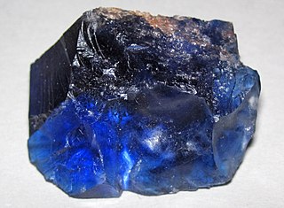
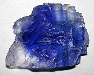
The Prairie Evaporite Formation, also known as the Prairie Formation, is a geologic formation of Middle Devonian (Givetian) age that consists primarily of halite and other evaporite minerals. It is present beneath the plains of northern and eastern Alberta, southern Saskatchewan and southwestern Manitoba in Canada, and it extends into northwestern North Dakota and northeastern Montana in the United States.

