Related Research Articles

Victoria Island is a large island in the Arctic Archipelago that straddles the boundary between Nunavut and the Northwest Territories of Canada. It is the eighth-largest island in the world, and at 217,291 km2 (83,897 sq mi)1 in area, it is Canada's second-largest island. It is nearly double the size of Newfoundland (111,390 km2 [43,010 sq mi]), and is slightly larger than the island of Great Britain (209,331 km2 [80,823 sq mi]) but smaller than Honshu (225,800 km2 [87,200 sq mi]). The western third of the island lies in the Inuvik Region of the Northwest Territories; the remainder is part of Nunavut's Kitikmeot Region. The population of 2,168 is divided between two settlements, the larger of which is Cambridge Bay (Nunavut) and the other Ulukhaktok.

The Arctic Archipelago, also known as the Canadian Arctic Archipelago, is an archipelago lying to the north of the Canadian continental mainland, excluding Greenland and Iceland.

The Jubilee line is a London Underground line that runs between Stanmore in suburban north-west London and Stratford in east London, via the Docklands, South Bank and West End. Opened in 1979, it is the newest line on the Underground network, although some sections of track date back to 1932 and some stations to 1879.

The Northern line is a London Underground line that runs between North London and South London. It is printed in black on the Tube map. It carries more passengers per year than any other Underground line – around 340 million in 2019 – making it the busiest tube line in London. The Northern line is unique on the Underground network in having two different routes through central London, two southern branches and two northern branches. Despite its name, it does not serve the northernmost stations on the Underground, though it does serve the southernmost station at Morden, the terminus of one of the two southern branches.

The Piccadilly line is a deep-level London Underground line running from the north to the west of London. It has two branches, which split at Acton Town, and serves 53 stations. The line serves Heathrow Airport, and some of its stations are near tourist attractions such as Piccadilly Circus and Buckingham Palace. The District and Metropolitan lines share some sections of track with the Piccadilly line. Printed in dark blue on the Tube map, it is the sixth-busiest line on the Underground network, with nearly 218 million passenger journeys in 2019.
Kohler Range is a mountain range in Marie Byrd Land, Antarctica. The range is about 40 nautical miles long and stands between the base of Martin Peninsula and Smith Glacier. The range consists of two ice-covered plateaus punctuated by several rock peaks and bluffs. The plateaus are oriented East-West and are separated by the Kohler Glacier, a distributary which flows north from Smith Glacier.

The Cariboo Regional District spans the Cities and Districts of Quesnel, Williams Lake, 100 Mile House, and Wells in the Central Interior of British Columbia.
Edmonton West stylized as Edmonton (West) from 1917 to 1921, was a provincial electoral district in Alberta, Canada, mandated to return a single member to the Legislative Assembly of Alberta from 1917 to 1921 and again from 1963 to 1971.
Mystery Lake is a local government district (LGD) in northern Manitoba. It surrounds the city of Thompson, although most of its territory lies to the southwest and south of the city. It is named after Mystery Lake, a lake located in the northeast section of the LGD, northeast of Thompson.

The Morant Cays is an offshore island group 51 km SSE off Morant Point, Jamaica. It is one of two offshore island groups belonging to Jamaica, the other one is the Pedro Cays.
Cayley is a hamlet in southern Alberta, Canada within the Foothills County. It is also recognized as a designated place by Statistics Canada.
The Scoresby Hills, also called the Scoresby Mountains, are a mountain range on the east coast of Bathurst Island, Nunavut, Canada. It consists of low hills which in turn form part of the Arctic Cordillera mountain system.
Disraeli Glacier is a glacier on northern Ellesmere Island, Nunavut, Canada. It lies in Quttinirpaaq National Park, South-West of the Disraeli Fiord. It is believed to have been named after Benjamin Disraeli, a British politician in the mid 1800s.

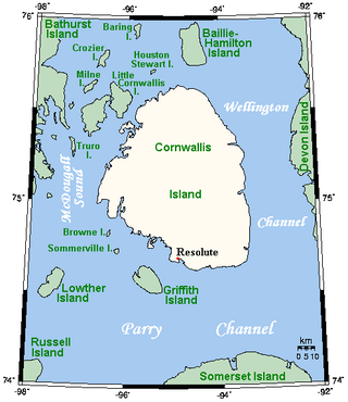
The Wellington Channel is a natural waterway through the central Canadian Arctic Archipelago in Qikiqtaaluk Region, Nunavut. It runs north–south, separating Cornwallis Island and Devon Island. Queens Channel lies to the west, separated by Baillie-Hamilton Island, Dundas Island, and Margaret Island.
The Fitzwilliam Strait is a natural waterway through the central Canadian Arctic Archipelago in the Northwest Territories of Canada. It separates Prince Patrick Island, Melville Island and Emerald Isle. It opens into the Kellett Strait to the south-west.
The Byam Channel is a natural waterway through the central Canadian Arctic Archipelago within Qikiqtaaluk Region, Nunavut, Canada. It separates Melville Island from Byam Martin Island. To the south it opens into the Parry Channel, and to the north are the Byam Martin Channel and Austin Channel.
The Pullen Strait is a natural waterway through the central Canadian Arctic Archipelago in the territory of Nunavut. It separates Little Cornwallis Island from Cornwallis Island, and is named after William Pullen.
Boyer Strait is a waterway in the Qikiqtaaluk Region of Nunavut, Canada. It separates Massey Island from Alexander Island. Île Marc is located at the western end of the strait, beyond which it opens into the Byam Martin Channel. To the east it opens into the Erskine Inlet.
The Murray Inlet is a large inlet on the south-west side of Melville Island, Northwest Territories, Canada. It joins the Liddon Gulf and M'Clure Strait to the south-west.
References
- ↑ Sailing Directions for Northern Canada. U.S. Government Printing Office. 1951. p. 356.