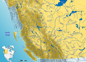
Canada has a vast geography that occupies much of the continent of North America, sharing a land border with the contiguous United States to the south and the U.S. state of Alaska to the northwest. Canada stretches from the Atlantic Ocean in the east to the Pacific Ocean in the west; to the north lies the Arctic Ocean. Greenland is to the northeast with a shared border on Hans Island. To the southeast Canada shares a maritime boundary with France's overseas collectivity of Saint Pierre and Miquelon, the last vestige of New France. By total area, Canada is the second-largest country in the world, after Russia. By land area alone, however, Canada ranks fourth, the difference being due to it having the world's largest proportion of fresh water lakes. Of Canada's thirteen provinces and territories, only two are landlocked while the other eleven all directly border one of three oceans.

The Mackenzie River is a river in the Canadian boreal forest. It forms, along with the Slave, Peace, and Finlay, the longest river system in Canada, and includes the second largest drainage basin of any North American river after the Mississippi.

The Peace River is a 1,923-kilometre-long (1,195 mi) river in Canada that originates in the Rocky Mountains of northern British Columbia and flows to the northeast through northern Alberta. The Peace River joins the Athabasca River in the Peace-Athabasca Delta to form the Slave River, a tributary of the Mackenzie River. The Finlay River, the main headwater of the Peace River, is regarded as the ultimate source of the Mackenzie River. The combined Finlay–Peace–Slave–Mackenzie river system is the 13th longest river system in the world.

The Liard River of the North American boreal forest flows through Yukon, British Columbia and the Northwest Territories, Canada. Rising in the Saint Cyr Range of the Pelly Mountains in southeastern Yukon, it flows 1,115 km (693 mi) southeast through British Columbia, marking the northern end of the Rocky Mountains and then curving northeast back into Yukon and Northwest Territories, draining into the Mackenzie River at Fort Simpson, Northwest Territories. The river drains approximately 277,100 km2 (107,000 sq mi) of boreal forest and muskeg.

Area code 867 is the area code in the North American Numbering Plan (NANP) for the three Canadian territories, all of which are in Northern Canada. The area code was created on October 21, 1997, by combining regions that were previously served with area code 403 and area code 819 in one numbering plan area (NPA). As the least populated NPA in mainland North America, serving about 130,000 people, it is geographically the largest, at 3,921,739 km2 (1,514,192 sq mi), with Alaska (907) a distant second.
The Mackenzie Highway is a Canadian highway in northern Alberta and the Northwest Territories. It begins as Alberta Highway 2 at Mile Zero in Grimshaw, Alberta. After the first 4.0 km (2.5 mi), it becomes Alberta Highway 35 for the balance of its length through Alberta and then becomes Northwest Territories Highway 1.

The Peace River Regional District is a regional district in northeastern British Columbia, Canada. The regional district comprises seven municipalities and four electoral areas. Its member municipalities are the cities of Fort St. John and Dawson Creek, the district municipalities of Tumbler Ridge, Chetwynd, Taylor, and Hudson's Hope, and the village of Pouce Coupe. The district's administrative offices are in Dawson Creek.

The Northern Rockies Regional Municipality (NRRM), formerly the Northern Rockies Regional District (NRRD), and before that the Fort Nelson–Liard Regional District, is a municipality in northeastern British Columbia, Canada. Although portrayed as a regional municipality in its official name, and existing on the same administrative level as a regional district, it is actually classified as a district municipality. The NRRM's offices are located in Fort Nelson, formerly an incorporated town that amalgamated with the NRRD on February 6, 2009 to form the NRRM. With the Peace River Regional District as the southern part, it was the northern part of the Peace River-Liard Regional District, which was split into two on October 31, 1987.

The Rocky Mountain Trench, also known as the Valley of a Thousand Peaks or simply the Trench, is a large valley on the western side of the northern part of North America's Rocky Mountains. The Trench is both visually and cartographically a striking physiographic feature extending approximately 1,600 km (1,000 mi) from Flathead Lake, Montana, to the Liard River, just south of the British Columbia–Yukon border near Watson Lake, Yukon. The trench bottom is 3–16 km (1.9–9.9 mi) wide and is 600–900 m (2,000–3,000 ft) above sea level. The general orientation of the Trench is an almost straight 150/330° geographic north vector and has become convenient as a visual guide for aviators heading north or south.

The Kechika River is a tributary of the Liard River, about 300 kilometres (190 mi) long, in northern British Columbia, Canada. The Kechika flows generally northwest through the northernmost section of the Rocky Mountain Trench before turning east to join the Liard, a major branch of the Mackenzie River system. The river's 22,700 km2 (8,800 sq mi) drainage basin is characterized by high glaciated peaks, boreal forest, and open tundra. With no settlements, roads or dams along its course, the Kechika is considered "one of British Columbia's finest examples of wilderness and undisturbed wildlife habitat."

The Muskwa River flows 257 kilometres (160 mi) through northern British Columbia, Canada. It is a major tributary of the Fort Nelson River - part of the Mackenzie River system. The river rises at Fern Lake in the Bedaux Pass in the Northern Rocky Mountains. From there, it flows generally east, then north, and then east again to meet with the Fort Nelson River just east of the town of Fort Nelson. The river drops approximately 1,100 metres (3,600 ft), its course taking it down the Rocky Mountain foothills through sub-alpine and boreal forest to meander across the forest and muskegs of the vast Liard River plains. From mouth to headwater, prominent tributaries include the Prophet River, Tuchodi River, and Gathto Creek. Much of the upper portions of this wilderness river and its watershed are located in the Northern Rocky Mountains Provincial Park, which is part of the larger Muskwa-Kechika Management Area. The region is a popular wilderness recreation destination.
Fort Liard is a hamlet in the Dehcho Region of the Northwest Territories, Canada. It is located 37 km (23 mi) north of the British Columbia border. It became accessible by road in 1984 with the completion of the Liard Highway.

The Hay River is a large river in northern Alberta and southern Northwest Territories, Canada.

Bistcho Lake is a large lake in northwestern Alberta, Canada.

Northern Alberta is a geographic region located in the Canadian province of Alberta.

Hornaday River is a waterway located above the Arctic Circle on the mainland of Northern Canada.
The Kotaneelee River is a river in the Northwest Territories of Canada. It is a tributary of the Liard River.
The Nahanni Formation is a stratigraphical unit of Givetian age in the Western Canadian Sedimentary Basin.

The Tsay Keh Dene First Nation is one of the Sekani bands of the Northern Interior of British Columbia. Tsay Keh Dene means "People of the Mountain". While they have an office in the City of Prince George, their territories, settlements, and Indian Reserves are all to the north, in the area of Williston Lake, whose creation as part of the W. A. C. Bennett Dam project flooded a large part of their territory with devastating effects on the people and their way of life.
Peace River-Liard Regional District was a regional district in northeastern British Columbia, spanning from Tumbler Ridge in the southwest to Lower Post on the northwest, in the angle of British Columbia's borders with Yukon, the Northwest Territories and Alberta. It was created on October 31, 1987, and split into Fort Nelson-Liard Regional District and the Peace River Regional District on October 31, 1987. The Fort Nelson-Liard Regional District was renamed the Northern Rockies Regional District, then made into the Northern Rockies Regional Municipality on May 26, 1999.