Related Research Articles

Copeland Islands Marine Provincial Park is a provincial park in British Columbia, Canada, located in Desolation Sound to the northwest of Lund on the northern Sunshine Coast off the west coast of the Malaspina Peninsula.
Francis Point Provincial Park is a provincial park in British Columbia, Canada, located on the southwest end of the Francis Peninsula, south of the community of Pender Harbour on the west side of the Sechelt Peninsula in the Sunshine Coast region. Established in 2004, the park is 83 ha. in size, 74 ha. of it upland, the other 9 ha. foreshore.
Garden Bay Marine Provincial Park is a provincial park in British Columbia, Canada at the northwest end of the Sechelt Peninsula on the lower Sunshine Coast, near the community of Madeira Park. Established in 1969, it is approximately 163 ha.
Malaspina Provincial Park is a provincial park in British Columbia, Canada, located on the northeast side of the Malaspina Peninsula facing Desolation Sound in the northernmost area of that province's Sunshine Coast region.

Dionisio Alcalá Galiano was a Spanish Navy officer, cartographer, and explorer. He mapped various coastlines in Europe and the Americas with unprecedented accuracy using new technology such as chronometers. He commanded an expedition that explored and mapped the Strait of Juan de Fuca and the Strait of Georgia, and made the first European circumnavigation of Vancouver Island. He reached the rank of brigadier and died during the Battle of Trafalgar.

Manuel Quimper Benítez del Pino was a Spanish Peruvian explorer, cartographer, naval officer, and colonial official. He participated in charting the Strait of Juan de Fuca and the Sandwich Islands in the late 18th century. He was later appointed a colonial governor in his native Peru at the beginning of the fight for independence there. He retired to Spain, but was able to return to Peru where he served as a naval officer in the new republic and pursued a literary career, publishing over 20 books about his experiences before his death there in Lima.
Nelson Island is an island in the Sunshine Coast region of the South Coast region of British Columbia. It is surrounded by Hotham Sound, Agamemnon Channel, and Malaspina Strait. The closest communities are Pender Harbour, British Columbia and Egmont, both on the Sechelt Peninsula.

Valdes Island is one of the Gulf Islands located in the Strait of Georgia, British Columbia, Canada. It is across Porlier Pass from Galiano Island, which lies to the southeast. It has an area of 23 square kilometres, and is 1.6 kilometres wide by 16 kilometres in length. The island is popular with kayakers, boaters and has historically been the site of several human settlements.

During the Age of Discovery, the Spanish Empire undertook several expeditions to the Pacific Northwest of North America. Spanish claims to the region date to the papal bull of 1493, and the Treaty of Tordesillas signed in 1494. In 1513, this claim was reinforced by Spanish explorer Vasco Núñez de Balboa, the first European to sight the Pacific Ocean, when he claimed all lands adjoining this ocean for the Spanish Crown. Spain only started to colonize the claimed territory north of present-day Mexico in the 18th century, when it settled the northern coast of Las Californias.

The Sechelt Peninsula is located on the Sunshine Coast of British Columbia, just northwest of Vancouver. It is bounded to the west by Malaspina Strait, to the north by Agamemnon Channel and Jervis Inlet, to the east by Sechelt Inlet, and to the south by the Strait of Georgia (separating it from Vancouver Island. Its approximately 350 km2 is a mixture of drier and wetter temperate rain forest. The Caren Range extends north–south along the shore of Sechelt Inlet. The peninsula is a popular outdoor recreation destination, containing many lakes and opportunities for shoreline and woodland hiking, including to the renowned Skookumchuk Narrows. There are several parks, the largest of which is Spipiyus Provincial Park in the interior of the peninsula.
Bliss Landing, formerly Bishop Landing or Bishops Landing, was a cannery town on the South Coast of British Columbia, Canada, located on the northwest side of the Malaspina Peninsula on the upper Sunshine Coast, north of the town of Lund and across the mouth of Desolation Sound from Cortes Bay and Manson's Landing on Cortes Island.

José Cardero was a Spanish draughtsman and artist. He is most remembered for his work on the expedition of Alejandro Malaspina and the related expedition of Dionisio Alcalá Galiano. During the Galiano voyage Cordero Channel was named in his honor. Other places in British Columbia were later named in his honor as well, including Dibuxante Point, "dibuxante" being Spanish for "draughtsman".
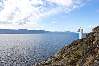
The Malaspina Peninsula is a peninsula in the northern Gulf of Georgia-Sunshine Coast region of British Columbia, Canada. It extends northwest from the town of Powell River, which lies near its isthmus, past the settlement of Lund, to Desolation Sound. This sound spans the opening of Toba Inlet, a fjord lying between Lund and the Discovery Islands to the west and northwest.
Agamemnon Channel is a channel or strait in British Columbia, Canada, at the mouth of Jervis Inlet on the South Coast, separating Nelson Island from the mainland of the Sunshine Coast. The ferry terminal and recreational community of Earls Cove is on its mainland side.
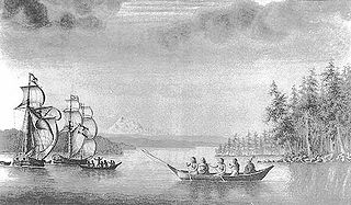
The Mexicana was a topsail schooner built in 1791 by the Spanish Navy at San Blas, New Spain. It was nearly identical to the Sutil, also built at San Blas later in 1791. Both vessels were built for exploring the newly discovered Strait of Georgia, carried out in 1792 under Dionisio Alcalá Galiano, on the Sutil, and Cayetano Valdés y Flores, on the Mexicana. During this voyage the two Spanish vessels encountered the two British vessels under George Vancouver, HMS Discovery and Chatham, which were also engaged in exploring the Strait of Georgia. The two expeditions cooperated in surveying the complex channels between the Strait of Georgia and Queen Charlotte Strait, in the process proving the insularity of Vancouver Island. After this first voyage the Mexicana continued to serve the San Blas Naval Department, making various voyages to Alta California and the Pacific Northwest coast.
The Gifford Peninsula is a peninsula on the east side of Desolation Sound in the Sunshine Coast region of the South Coast of British Columbia, Canada, located immediately north of the Malaspina Peninsula and separated from it by Malaspina Inlet. On its east side is Lancelot Inlet and its arm Theodosia Inlet
Lancelot Inlet is an inlet in the Sunshine Coast region of the South Coast of British Columbia, Canada. It is a sidewater of Malaspina Inlet, and immediately east of the Gifford Peninsula. Via Thors Cove on its east side, its own sidewater is Theodosia Inlet, at the head of which is the mouth of the Theodosia River. The locality of Theodosia Arm is located here.
Larsons Landing is a steamer landing on the northwest shore of Okeover Inlet, which is the upper end of Malaspina Inlet in the Sunshine Coast region of British Columbia, Canada.
The Coode Peninsula is a small peninsula on the inner side of the larger Malaspina Peninsula in the Sunshine Coast area of the South Coast of British Columbia, Canada, projecting into Malaspina Inlet just south of Okeover Inlet.
References
- ↑ Walbran, John T. (1909). British Columbia coast names, 1592-1906 : to which are added a few names in adjacent United States territory, their origin and history. Ottawa Government Printing Bureau. pp. 313–314. OCLC 317633225. Archived from the original on 2012-03-07. Retrieved 2010-01-25.
49°40′00″N124°15′00″W / 49.66667°N 124.25000°W
| | This article about a location on the South Coast of British Columbia, Canada is a stub. You can help Wikipedia by expanding it. |