The river and its drainage basin contain a wide range of industrial and recreational activities. Logging and coal mining[2] were a couple of the earliest industrial operations. While coal mining ceased in the first half of the 20th century, logging continues to be important. Morden Colliery Historic Provincial Park is one of the few places left near the river that links to the region's coal mining history. Due to the lack of arable land, agriculture never became an important industry. In 1931, South Fork Dam was built upstream on the South Nanaimo River to supply water to the city of Nanaimo.[3] In 1974, an additional dam and reservoir were built farther upstream on a tributary of the South Nanaimo River to increase the water supply for the city. In 2000, the South Fork Dam was upgraded to produce Hydroelectricity.
Two major highways cross the river. The Trans-Canada Highway crosses the river just north of Cassidy and farther downstream Highway 19 crosses on the north side of Cedar. At the point where the Trans-Canada Highway crosses the river, the Esquimalt & Nanaimo Railway also crosses it. On the east side of Cassidy, just of the south bank of a major tributary of the river, Haslam Creek, is the Nanaimo Airport[4]
All along the river, and throughout its watershed, there are plenty of lakes and recreational opportunities, including boating, camping, hiking, bungee jumping, and rock climbing. There are still pockets of old growth forest left within easy access to the public, such as at the Nanaimo River Regional Park.
First Nations
Along the Nanaimo River are the archaeological remains of five fall and winter Coast Salish villages. The villages are called Solachwan, Tewahlchin, Anuweenis, Kwalsiarwahl, and Ishihan.[5] The villages were often occupied until April, in which the Coast Salish would then travel to Gabriola Island to hunt.[6] The Nanaimo River was the lifeblood of the Coast Salish people living in modern-day Nanaimo.
The Nanaimo River is part of the traditional territory of the Snuneymuxw and Stz'uminus First Nations. In total, the Snuneymuxw have six Indian reserves in the Nanaimo area. Nanaimo Town 1 is located on the west side of Nanaimo Harbour, just south of downtown Nanaimo. Three others, Nanaimo River 2, 3, and 4 are located on the Nanaimo River delta. Gabriola Island 5 is on Gabriola Island and Ma-guala 6 is on a small island in Degnen Bay on the south-west coast of Gabriola Island.
The source of the Nanaimo River is the eastern slopes of Mount Hooper.[7] Mount Hooper is on the drainage divide that separates rivers flowing eastward towards the Strait of Georgia and westwards into the open Pacific Ocean. The western slopes of Mount Hooper are in the Nitinat River's watershed.[8]
From its source, the Nanaimo River flows east for most of its length then north into the south end of Nanaimo Harbour. There are two lakes, First and Second, along the river's course and multiple tributaries and other lakes in its watershed.[9]
Other than the aforementioned Indian reserves, the small community of Cedar is the only community along the banks of the river. Other small communities, such as Cassidy (which straddles Haslam Creek), South Wellington, and Extension are found nearby in the river's lower watershed.
The total watershed area of the river is 95,000ha (230,000 acres) and the mainstem river channel from the source to the mouth is 78 kilometres (48mi). The section from First Lake to the harbour is about 56 kilometres (35mi) long.
Tributaries
The Nanaimo River has three main tributaries and several smaller ones. The North Nanaimo River, often referred to as North Fork, starts south-west of Okay Mountain and travels south and joins with the Nanaimo River at the outflow of First Lake.[10] The South Nanaimo River, often referred to as South Fork, starts at Rheinhart Lake[11] and flows north and meets the mainstem a short distance downstream from the North Fork. Almost the entirety of the South Fork watershed is restricted to public access as that's the source of Nanaimo's water. The watershed itself is 230km2 (89sqmi) and is privately owned by Timberlands. An agreement between Timberlands and the city of Nanaimo was formed to safeguard the drinking water supply.[12] Haslam Creek[13] is the other main tributary. Its source is only a short distance east of South Nanaimo River's source, Rheinhart Lake. While South Nanaimo travels north to meet the main stem, Haslam Creek flows east-northeast to meet the Nanaimo River near the Nanaimo River Fish Hatchery and Nanaimo River Regional Park.
Nanaimo River tributaries from the headwaters to mouth
Sadie Creek
Rockyrun Creek
Green Creek
Bell Creek
Fleece Creek
Rush Creek
Dash Creek
Deadhorse Creek
North Nanaimo River
Blackjack Creek
Anderson Creek
Wolf Creek
Price Creek
South Nanaimo River
Jump Creek
Dunsmuir Creek
Whisky-jack Creek
Boulder Creek
Manson Creek
Elkhorn Creek
Berkley Creek
Stark Creek
Haslam Creek
North Haslam Creek
Hokkanen Creek
Lakes and reservoirs
A chain of four lakes, collectively called the Nanaimo Lakes, follow the river's course. Only First and Second Lake, though, are actually part of the river. Third Lake is connected via a short stream to Nanaimo River, just west of Second Lake. Fourth Lake is a man-made reservoir along Sadie Creek that is used to supply water for Harmac Pacific. Two other man-made lakes, Jump Lake[14] and South Fork Reservoir, are operated by the city of Nanaimo and supply water to Nanaimo and the surrounding area.[15] Other notable lakes in the watershed include Blackjack Lake, Quennell Lake, Michael Lake, Crystal Lake, Blind Lake, and Whisky Lake.
Jump Lake Dam
Jump Lake Dam
Jump Lake Dam is an earthen dam along the course of Jump Creek, which starts at Butler Peak and flows northward where it meets the South Nanaimo River at the same spot as east flowing Dunsmuir Creek. Jump Lake Dam was built in 1974 to create a stable source of drinking water for Nanaimo and area. It can hold 17,000,000m3 (14,000acre⋅ft) of water, which is enough to supply every home in Nanaimo for a year.[16] Water levels in Jump Lake are regulated so that downstream South Fork Reservoir remains at full supply level all the time and other reservoirs downstream have a constant supply of water.
South Fork Dam
Farther down stream, along the South Nanaimo River, about where Whisky-jack Creek meets South Nanaimo River, is South Fork Reservoir. South Fork Reservoir was created in 1931 with the completion of South Fork Dam. The dam is 50.3m (165ft) wide and 30.5m (100ft) tall and is built of unreinforced concrete. The reservoir holds 2,000,000m3 (1,600acre⋅ft) of water and it is kept full as Nanaimo's water delivery system is gravity fed. Two pipelines, one 750mm (30in) and the other 1,200mm (47in) in diameter, carry water downstream to Nanaimo, where there are additional holding reservoirs. The 750mm (30in) pipeline was built in 1954 and has a capacity of 50,000m3 (41acre⋅ft) of water a day. The other pipeline was completed in 1993 and has a capacity of 190,000m3 (150acre⋅ft) a day. In 2000, South Fork Dam was upgraded to produce hydroelectricity for local uses.[17]
There are nine balancing reservoirs located throughout the city to meet peak domestic demand. The first balancing reservoir was built at Lost Lake in Nanaimo's north end in 1969. That was followed by reservoirs at College Park and Rutherford Road. During the 1980s, additional reservoirs were built at Duke Point Industrial Park, Langara Drive, and Tanya Drive. More recently, another reservoir was added near Extension in 2010 and in 2014 the open reservoir on Nanaimo Lakes Road was replaced by a new reservoir and energy recovery facility.[18]
Parks and recreation
The Nanaimo River Regional Park is a regional park near the end of the river in the Regional District of Nanaimo. In 1999 and 2000, The Land Conservancy of British Columbia (TLC) purchased the last two remaining intact riparian zones on the lower Nanaimo River. The site contains two parcels totalling about 56ha (140 acres) of old growth Douglas fir with undisturbed river bank. One parcel is 16.2ha (40 acres) and the other is 40.5ha (100 acres). TLC applied for creditor protection in 2013 and on 30 September 2015, 26 properties, including the two on the Nanaimo River, were transferred to the Nature Conservancy of Canada. Shortly thereafter, the Nature Conservancy of Canada transferred the two parcels over to the Nature Trust of British Columbia. Besides conservation, Nanaimo River Regional Park offers walking / cycling trails, swimming, and wildlife viewing.[19]
The river has a notable canyon, which is the site of WildPlay Element Parks's bungee jumping operation. The bridge used for bungee jumping is North America's first purpose built, legal bridge for bungee jumping.[20]
Upstream, and to the west of WildPlay Element Park, is a rock-climbing area with several rock climbs of varying difficulty.[21]
Along the course of the river, there are many popular swimming holes. There are deep pools, underwater caves, waterfalls, rocky beaches, and strong currents.[22]
In 1963, a ski hill and lodge were built on Green Mountain (49°03′24″N124°20′32″W / 49.05667°N 124.34222°W / 49.05667; -124.34222),[23] south-west of Third Lake and south-east of Forth Lake. Green Mountain Ski Hill was run by volunteers and operated until 1984. In 1984, the lodge and T-bar were vandalised. It was deemed too expensive to repair and the ski hill was permanently closed.[24]
On one of Nanaimo River's main tributaries, Haslam Creek, there's a suspension bridge across the creek that's part the Trans Canada Trail. The trail leads to Timberland Lake.[25] Also along Haslam Creek are two golf courses, Cottonwood Golf Course[26] and Rondalyn Resort. Rondalyn Resort is also an RV campground. Another campground just downstream of Rondalyn is Birds Nest Campground.
Nanaimo River Fish Hatchery
From the Nanaimo River Fish Hatchery's[27] inception in 1979 until 2004, it was operated by Community Futures Central Island.[28] In 2004, the non-profit Nanaimo River Stewardship Society was formed and currently operates the facility relying heavily on volunteers and donations.
The Nanaimo River watershed supports pockets of old growth Douglas fir forest. The Douglas fir forests are part of the Georgia-Puget Basin Ecoregion and were recently classified as the 65th of 77 most significant and threatened places in Canada.[30]
A variety of animals, such as Vancouver Island marmots, cougars, wolves, golden eagles, and various species of deer call the mountains of the watershed home. The Nanaimo River is also regarded by anglers as one of the best steelhead rivers in the country.[31]
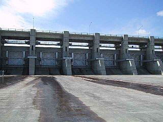
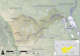
The Gardiner Dam on the South Saskatchewan River in Saskatchewan is the third largest embankment dam in Canada and one of the largest embankment dams in the world. Construction on Gardiner Dam and the smaller Qu'Appelle River Dam was started in 1959 and completed in 1967, creating Lake Diefenbaker upstream and diverting a considerable portion of the South Saskatchewan's flow into the Qu'Appelle River. The dam rises 64 metres (209 feet) in height, is almost 5 km (3.1 mi) long and has a width of 1.5 km (0.93 mi) at its base with a volume of 65,000,000 cubic meters. The dam is owned and operated by the Saskatchewan Water Security Agency.
The Antler River is located in the Prairie Pothole Region of North America's Great Plains in south-eastern Saskatchewan and south-western Manitoba in Canada in an area known as Palliser's Triangle. Its source is in Saskatchewan's Moose Mountain Upland and it is a major tributary of the Souris River. As a result, its flood levels are monitored by the United States Geological Survey.
Last Mountain Lake, also known as Long Lake, is a prairie lake formed from glaciation 11,000 years ago. It is located in south central Saskatchewan, Canada, about 40 kilometres (25 mi) north-west of the city of Regina. It flows into the Qu'Appelle River via Last Mountain Creek, which flows past Craven. It is approximately 93 km (58 mi) long, and 3 km (1.9 mi) wide at its widest point. It is the largest naturally occurring body of water in southern Saskatchewan. Only Lake Diefenbaker, which is man-made, is larger. The lake is a popular resort area for residents of south-eastern Saskatchewan.
Wascana Creek is a river in the Canadian province of Saskatchewan. It is a tributary of the Qu'Appelle River.
Torch River is a river in the Canadian province of Saskatchewan. The river's source is the dam at Candle Lake, near Candle Lake Provincial Park, and it travels east through boreal forest and muskeg en route to its mouth in the Saskatchewan River Delta. Torch River Provincial Forest, a conservation area, is located along the course of the river, near where White Fox River flows into Torch River. Torch River is a significant tributary of the Saskatchewan River and it is part of the Hudson Bay drainage basin.
Boundary Dam Reservoir is a man-made lake in the south-east corner of the Canadian province of Saskatchewan. It is in census division 1, in the RM of Estevan. The closest city is Estevan, which is about 5.5 kilometres (3.4 mi) downstream. There are no towns or villages along the lake's shore but there are two subdivisions and a regional park. The subdivisions, which are in the RM of Estevan, are called Sunset Bay and Lakewood. The primary inflow and outflow for the reservoir is Long Creek. There is a 10-kilometre long diversion channel that goes to McDonald Lake that can take excess water in either direction.
Blackstrap Lake is a man-made reservoir in central Saskatchewan, Canada, south of Saskatoon in the Rural Municipality of Dundurn No. 314. The lake was created as a reservoir in 1967, as part of the Saskatoon South East Water Supply System. Blackstrap Lake has an area of 1,200 ha and is generally used to support irrigation, and the industrial and municipal water supply.
Indi Lake is a man-made lake in central Saskatchewan, Canada, south of Saskatoon in the Rural Municipality of Dundurn No. 314. The lake was created for irrigation and recreation in 1967 by a dam located at its south end. The lake is part of a greater irrigation and aqueduct system built in the 1960s in Saskatchewan and was named after Indi, an unincorporated railway point nearby on the Canadian National Railway (CNR).
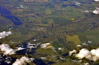
Nanaimo Harbour, also known as the Port of Nanaimo, is a natural harbour on the east coast of Vancouver Island in the Canadian province of British Columbia. The city of Nanaimo runs along the west side of the harbour. Three islands, Newcastle, Protection, and Gabriola, along with Duke Point, form the eastern edge. The Port of Nanaimo includes the Inner Harbour, Nanaimo River estuary, Departure Bay, the waters on the east side of Newcastle and Protection Islands, and Northumberland Channel. The port is under the management of the Nanaimo Port Authority.
Chase River is a river on Vancouver Island in the Canadian province of British Columbia. It discharging into the Strait of Georgia at the south end of Nanaimo Harbour. It is the namesake of the city of Nanaimo's neighbourhood of Chase River.
Pipestone Creek is a river in the Souris River watershed. Its flow begins in southeastern Saskatchewan, just south of the town of Grenfell and travels in a southeastern direction into Manitoba in the Westman Region where it empties into Oak Lake through the Oak Lake Marsh.
Moose Mountain Creek is a river in the Canadian province of Saskatchewan. Its source is the Chapleau Lakes near Montmartre and it is a tributary of the Souris River, which, in turn, is a tributary of the Assiniboine River. The whole system is part of the Red River watershed, which is part of the Hudson Bay drainage basin and in a region called the Prairie Pothole Region of North America, which extends throughout three Canadian provinces and five U.S. states. It is also within Palliser's Triangle and the Great Plains ecoregion.
Last Mountain Creek is a river in south-central Saskatchewan. It is a tributary of the Qu'Appelle River in a region called the Prairie Pothole Region of North America, which extends throughout three Canadian provinces and five U.S. states. It is also within Palliser's Triangle and the Great Plains ecoregion.
Lanigan Creek is a river in the Canadian province of Saskatchewan. It is located in the south central part of the province in a region called the Prairie Pothole Region of North America, which extends throughout three Canadian provinces and five U.S. states. It is also within Palliser's Triangle and the Great Plains ecoregion.
Brightwater Creek is a river in south central part of the Canadian province of Saskatchewan. It is a tributary of the South Saskatchewan River in a region called the Prairie Pothole Region of North America, which extends throughout three Canadian provinces and five U.S. states. It is also within Palliser's Triangle and the Great Plains ecoregion. Along the river's course there is a dam and reservoir and a regional park. There are no communities along its course.
Nitinat River is a river on the west coast of Vancouver Island in the Canadian province of British Columbia. Its source is in the Vancouver Island Ranges at McKinlay Peak. It travels in a south-west direction from its source until it meets Nitinat Lake at the Pacific Ocean.
Oak Lake is a lake in the south-western part of the Canadian province of Manitoba in a region called Westman. Oak Lake is a kettle lake and is an aquifer supplier for numerous nearby residential areas and farms. The lake is in the RM of Sifton and sits at an elevation of 426 metres above sea level. Provincial Road 254 provides access to the lake.
Craven Dam is at the confluence of the Qu'Appelle River and Last Mountain Creek and immediately east of the village of Craven on the Qu'Appelle River at LSD SW 24-20-21 W2. It is in the Canadian province of Saskatchewan in the RM of Longlaketon No. 219. The dam does not create a reservoir as its purpose is to regulate water flow along the Qu'Appelle River. The dam is operated by the Saskatchewan Water Security Agency and can be accessed on the north side by Highway 99.
First Mustus Lake is a lake in Meadow Lake Provincial Park in the Canadian Province of Saskatchewan in the boreal forest ecozone of Canada. The lake is the first of four lakes in a row named Mustus in the Rusty Creek watershed. The other lakes are Second, Third, and Fourth Mustus. Rusty Creek and the lakes are part of the Waterhen River drainage basin. The Waterhen River is a tributary of the Beaver River, which flows north into Lac Île-à-la-Crosse and the Churchill River, a major tributary in the Hudson Bay drainage basin. Highway 224 provides access to both First and Second Mustus Lakes.
Pepaw River, also spelt Peepaw, is a river in the east-central part of the Canadian province of Saskatchewan in the boreal forest ecozone of Canada. It begins in the Porcupine Hills and flows northward and meets up with the Etomami River south of the town of Hudson Bay. Much of the river is within Saskatchewan's Porcupine Provincial Forest and as such has various recreational opportunities along its course.
References
↑ "Nanaimo River". Canadian Geographical Names Database. Government of Canada. Retrieved 5 January 2023.
This page is based on this Wikipedia article Text is available under the CC BY-SA 4.0 license; additional terms may apply. Images, videos and audio are available under their respective licenses.