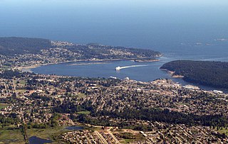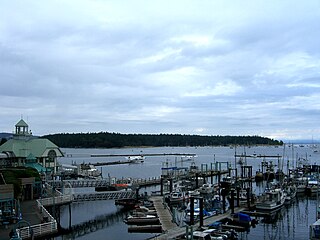
Nanaimo is a city of about 100,000 on the east coast of Vancouver Island, in British Columbia, Canada. "The Harbour City" was previously known as the "Hub City", which was attributed to its original layout design with streets radiating from the shoreline like the spokes of a wagon wheel, and to its relatively central location on Vancouver Island. Nanaimo is the headquarters of the Regional District of Nanaimo.

Parksville is a city on Vancouver Island in British Columbia, Canada. As of the 2021 Census, Parksville's population was 13,642, representing a 9.5% increase over the 2016 Census.

The Snuneymuxw First Nation is located in and around the city of Nanaimo on east-central Vancouver Island, British Columbia, Canada. The nation previously had also occupied territory along the Fraser River, in British Columbia.

Departure Bay is a bay in central Nanaimo, British Columbia, on the east coast of Vancouver Island. The surrounding neighbourhood is also referred to as "Departure Bay" —once a settlement of its own, it was amalgamated into the City of Nanaimo in the 1970s.
Nitinat River Provincial Park is a provincial park in the Canadian province of British Columbia on Vancouver Island.
Cedar is a small community in the Canadian province of British Columbia. It is located near the east coast of Vancouver Island — about 8 kilometres (5.0 mi) south-east of Nanaimo — along the banks of the Nanaimo River. Its geographical coordinates are 49°07′N123°51′W.

Harewood is the name of a lake and a plain of the Canadian province of British Columbia. It is located in Nanaimo, on the east coast of Vancouver Island. Its geographical coordinates are 49°08′N123°57′W The name has been in use since at least 1913, when Harewood referred to a small mining village in the area, no longer existing, having been overtaken by Nanaimo. The mine was owned in part by the seventh son of Henry Lascelles, 3rd Earl of Harewood who served on the BC coast as captain of the gunboat HMS Forward and set up the Harewood Coal Mining Company to work deposits he acquired.

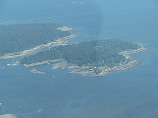
Protection Island is a small island located 1.5 km north-east of downtown Nanaimo, British Columbia, Canada in the Nanaimo Harbour. The island was originally named Douglas Island, after James Douglas the first Governor of the Colony of Vancouver Island and British Columbia. It was renamed Protection Island in 1960. The permanent year-round population is about 350 people.

The Antler River is located in the Prairie Pothole Region of North America's Great Plains in south-eastern Saskatchewan and south-western Manitoba in Canada in an area known as Palliser's Triangle. Its source is in Saskatchewan's Moose Mountain Upland and it is a major tributary of the Souris River. As a result, its flood levels are monitored by the United States Geological Survey.

Last Mountain Lake, also known as Long Lake, is a prairie lake formed from glaciation 11,000 years ago. It is located in south central Saskatchewan, Canada, about 40 kilometres (25 mi) north-west of the city of Regina. It flows into the Qu'Appelle River via Last Mountain Creek, which flows past Craven. It is approximately 93 km (58 mi) long, and 3 km (1.9 mi) wide at its widest point. It is the largest naturally occurring body of water in southern Saskatchewan. Only Lake Diefenbaker, which is man-made, is larger. The lake is a popular resort area for residents of south-eastern Saskatchewan.

Wascana Creek is a river in the Canadian province of Saskatchewan. It is a tributary of the Qu'Appelle River.
Mount Benson is a mountain located on Vancouver Island, British Columbia located 9 km (5.6 mi) west of Nanaimo. At one time, there was road access to the peak as there was a fire lookout at the summit. Today, the road is closed to vehicles but the mountain has become popular with local hikers as it has great views of the Strait of Georgia, the mainland Coast Mountains of British Columbia, the Nanaimo River valley, and the Vancouver Island Ranges, including Mount Arrowsmith.

Nanaimo River is a river on Vancouver Island, British Columbia, Canada, located near the city of Nanaimo on the island's east coast. Its headwaters are in the Vancouver Island Ranges of central Vancouver Island and its mouth, the Nanaimo River estuary, is at the south end of Nanaimo Harbour in the Strait of Georgia. The estuary is part of the Pacific Estuary Conservation Program.

Nanaimo Harbour, also known as the Port of Nanaimo, is a natural harbour on the east coast of Vancouver Island in the Canadian province of British Columbia. The city of Nanaimo runs along the west side of the harbour. Three islands, Newcastle, Protection, and Gabriola, along with Duke Point, form the eastern edge. The Port of Nanaimo includes the Inner Harbour, Nanaimo River estuary, Departure Bay, the waters on the east side of Newcastle and Protection Islands, and Northumberland Channel. The port is under the management of the Nanaimo Port Authority.
Chase River is a neighbourhood in the south end of the city of Nanaimo, British Columbia, Canada on the east coast of Vancouver Island. It is named for the Chase River which runs through the community.

Moose Mountain Creek is a river in the Canadian province of Saskatchewan. Its source is the Chapleau Lakes near Montmartre and it is a tributary of the Souris River, which, in turn, is a tributary of the Assiniboine River. The whole system is part of the Red River watershed, which is part of the Hudson Bay drainage basin and in a region called the Prairie Pothole Region of North America, which extends throughout three Canadian provinces and five U.S. states. It is also within Palliser's Triangle and the Great Plains ecoregion.

Brightwater Creek is a river in south central part of the Canadian province of Saskatchewan. It is a tributary of the South Saskatchewan River in a region called the Prairie Pothole Region of North America, which extends throughout three Canadian provinces and five U.S. states. It is also within Palliser's Triangle and the Great Plains ecoregion. Along the river's course there is a dam and reservoir and a regional park. There are no communities along its course.
Nitinat River is a river on the west coast of Vancouver Island in the Canadian province of British Columbia. Its source is in the Vancouver Island Ranges at McKinlay Peak. It travels in a south-west direction from its source until it meets Nitinat Lake at the Pacific Ocean.

Oak Lake is a lake in the south-western part of the Canadian province of Manitoba in a region called Westman. Oak Lake is a kettle lake and is an aquifer supplier for numerous nearby residential areas and farms. The lake is in the RM of Sifton and sits at an elevation of 426 metres above sea level. Provincial Road 254 provides access to the lake.

Pepaw River, also spelt Peepaw, is a river in the east-central part of the Canadian province of Saskatchewan in the boreal forest ecozone of Canada. It begins in the Porcupine Hills and flows northward and meets up with the Etomami River south of the town of Hudson Bay. Much of the river is within Saskatchewan's Porcupine Provincial Forest and as such has various recreational opportunities along its course.


