
Glendalough is a glacial valley in County Wicklow, Ireland, renowned for an Early Medieval monastic settlement founded in the 6th century by St Kevin. From 1825 to 1957, the head of the Glendalough Valley was the site of a galena lead mine. Glendalough is also a recreational area for picnics, for walking along networks of maintained trails of varying difficulty, and also for rock-climbing.

The Red Rock Canyon National Conservation Area in Clark County, Nevada, is an area managed by the Bureau of Land Management as part of its National Landscape Conservation System, and protected as a National Conservation Area. It is about 15 miles (24 km) west of Las Vegas, and is easily seen from the Las Vegas Strip. More than two million people visit the area each year.

Wreck Beach is a clothing-optional beach located in Pacific Spirit Regional Park, which is in turn part of the University Endowment Lands just west of Vancouver, British Columbia, Canada. The clothing-optional section is clearly marked with signs and stretches approximately 6.7 kilometres or 4.2 miles from Acadia Beach, in the north, to the Booming Grounds Creek on the north arm of the Fraser River. The park is administered by the Greater Vancouver Regional District (GVRD), though aboriginal claims are repeatedly asserted, especially by the Musqueam.

The Delaware Water Gap is a water gap on the border of the U.S. states of New Jersey and Pennsylvania where the Delaware River cuts through a large ridge of the Appalachian Mountains. The gap constitutes the southern portion of the Delaware Water Gap National Recreation Area, which is used primarily for recreational purposes, such as rafting, canoeing, swimming, fishing, hiking, and rock climbing.

The Trans Canada Trail, or The Great Trail, is a cross-Canada system of greenways, waterways, and roadways that stretches from the Atlantic to the Pacific to the Arctic oceans. The trail extends over 24,000 kilometres ; it is now the longest recreational, multi-use trail network in the world. The idea for the trail began in 1992, shortly after the Canada 125 celebrations. Since then it has been supported by donations from individuals, corporations, foundations, and all levels of government.

Mount Forbes, the eighth tallest mountain in the Canadian Rockies, is located 18 km (11 mi) southwest of the Saskatchewan River Crossing in Banff National Park. The mountain was named by James Hector in 1859 after Edward Forbes, Hector's natural history professor at the University of Edinburgh during the mid-nineteenth century.
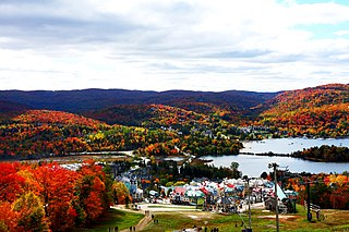
Mont Tremblant Ski Resort is a year-round resort in the Laurentian Mountains of Quebec, Canada, located about 130 km (80 mi) northwest of Montreal. It is best known as a ski destination, but also features Lake Tremblant suitable for swimming and two golf courses in the summer months. The name of the mountain, Mont Tremblant, was derived from the Algonquin indigenous people, who called it the "trembling mountain." The summit is at an elevation of 875 m (2,871 ft), which makes it one of the tallest peaks in the Laurentians. The resort is owned by Alterra Mountain Company.
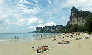
Railay, also known as Rai Leh, is a large peninsula between the city of Krabi and Ao Nang in Thailand. It is accessible only by boat due to high limestone cliffs cutting off mainland access. These cliffs attract rock climbers from all over the world, but the area is also popular due to its beautiful beaches and quiet relaxing atmosphere. Accommodation ranges from bungalows and medium-priced resorts in East Railay to a collection of luxury resorts focused on West Railay, though one, Rajavadee, spans both waterfronts and also has a beachfront restaurant at Ao Phra Nang. The four main areas of Railay consist of Phra Nang, West Railay, East Railay, and Ton Sai. Ton Sai caters to climbers and the backpacker set and is more rustic in character than the glitz of West Railay and the shops and restaurants of the East Railay boardwalk.

Smith Rock State Park is an American state park located in central Oregon's High Desert near the communities of Redmond and Terrebonne. Its sheer cliffs of tuff and basalt are ideal for rock climbing of all difficulty levels. Smith Rock is generally considered the birthplace of modern American sport climbing, and is host to cutting-edge climbing routes. It is popular for sport climbing, traditional climbing, multi-pitch climbing, and bouldering.
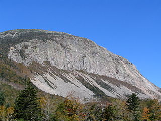
Cannon Mountain is a 4,080-foot (1,240 m) peak in the White Mountains of New Hampshire. It is known for both its technical rock and ice climbing on its cliff face and skiing at Cannon Mountain Ski Area. It was also home to the Old Man of the Mountain, until that formation collapsed on May 3, 2003.
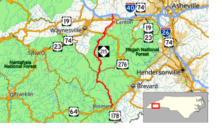
North Carolina Highway 215 (NC 215) is a highway in western North Carolina that runs from the town of Rosman in Transylvania County to Canton at Interstate 40 and U.S. Route 74 (US 74). The portion from Canton to Rosman is a part of the National Forest Service's Forest Heritage Scenic Byway. It travels high into the mountains along a scenic stretch of the upper West Fork of the Pigeon River, and intersects the Blue Ridge Parkway at Beech Gap at an elevation of approximately 5,300 feet (1,600 m).

Difficult Run is a 15.9-mile-long (25.6 km) tributary stream of the Potomac River in Northern Virginia in the United States. The area has had many historical uses dating back to the early 1800s. Today, the area is used recreationally by visitors interested in the watershed's variety of options including hiking, biking, fishing, boating, climbing, and bird watching. The wildlife at Difficult Run is vast as 163 different species can be seen depending on the season. There are 41 different soil types found on the trail and alongside the stream. The stream is part of the greater 57.7- square-mile Drainage basin, or watershed, located in the north-central portion of Fairfax County and drains directly to the Potomac River.

The Cape Cod Rail Trail (CCRT) is a 22-mile (35 km) paved rail trail located on Cape Cod in Massachusetts. The trail route passes through the towns of Dennis, Harwich, Brewster, Orleans, Eastham, and Wellfleet. It connects to the 6-plus mile (10 km) Old Colony Rail Trail leading to Chatham and 8 miles (13 km) of trails within Nickerson State Park. Short side trips on roads lead to national seashore beaches including Coast Guard Beach at the end of the Nauset Bike Trail in Cape Cod National Seashore.
Hackensack RiverWalk a is partially constructed greenway along the Newark Bay and Hackensack River on the west side of the Bergen Neck peninsula in Hudson County, New Jersey. The eight-mile walkway, following the contour of the water's edge, will run between the southern tip at Bergen Point, where it may connect to the Hudson River Waterfront Walkway, and Eastern Brackish Marsh in the north. Existing parks and promenades have been incorporated and some new sections have been built, but there remain large gaps. There is a RiverWalk in the city of Hackensack, sometimes called the Hackensack RiverWalk, but they are not part of the same project nor are they connected. A parallel walkway on the west banks of the river is known as the Meadow Path.

The Ringwood - Belgrave Rail Trail is a shared use path for cyclists and pedestrians, which follows the Belgrave railway line from the Mullum Mullum Creek Trail in Ringwood to Belgrave railway station in Belgrave, in the outer eastern suburbs of Melbourne, Victoria, Australia.

Tumbledown Mountain is a mountain in Franklin County, Maine. The mountain is a popular hiking spot in western Maine, with trailheads located on Byron Road in unincorporated Township 6, north of Weld. It is distinguished by an alpine pond just below the summit. Tumbledown Mountain is also located near Coos Canyon, a mountain stream. Tumbledown offers trails of varying difficulty for different hikers.

Mount Minsi forms the Pennsylvania side of the Delaware Water Gap, and is the eastern extent of the Blue Mountain. It is composed of sandstone and conglomerates of the Shawangunk Formation.

Carderock Recreation Area is a 100-acre park in Carderock, Maryland, part of the Chesapeake and Ohio Canal National Historical Park. The area is well known as a destination for its outdoor activities of rock climbing, hiking and biking. It is bounded by the Potomac River on the south and the Chesapeake and Ohio Canal on the north, and it is accessed from Clara Barton Parkway from the same exit as Carderock Division of the Naval Surface Warfare Center.

Hiking, rock climbing, and mountain climbing around Tuolumne Meadows in Yosemite National Park has many options, below divided.


