Stuart Island is one of the Discovery Islands of British Columbia, which lie between northern Vancouver Island and the British Columbia Coast. It is privately owned and has no ferry access. It is situated at the mouth of Bute Inlet to the east of the larger Sonora Island within Electoral Area C of the Strathcona Regional District. The island, and Bute Inlet, were named for John Stuart, 3rd Earl of Bute, Prime Minister of Great Britain from 1762 to 1763.

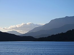
Bute Inlet is one of the principal inlets of the British Columbia Coast. It is 80 km (50 mi) long from the estuaries of the Homathko and Southgate Rivers at the head of the inlet, to the mouth, where it is nearly blocked by Stuart Island, and it averages about 4 km (2.5 mi) in width. Bute Inlet is in a spectacular wilderness setting and is one of the most scenic waterways in the world. In the upper reaches of the inlet mountains rise 2,700 m (9,000 ft) feet above sea level. Bute Inlet is a spectacular wilderness that is visited by very few people. In more recent years tourists are travelling from around the world to view grizzly bears in a natural setting and explore the wilderness of Bute Inlet.

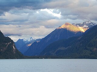
Knight Inlet is one of the principal inlets of the British Columbia Coast, and the largest of the major inlets in the southern part of the Coast. It is fifth in sequence of the great saltwater inlets north from the 49th parallel near Vancouver, but it is the first whose outflow points away from the Strait of Georgia, opening into Queen Charlotte Strait at the Kwakwakaʼwakw community of Memkumlis on Village Island.
Kingcome Inlet is one of the lesser principal fjords of the British Columbia Coast, north and east of Broughton Island. It is sixth in sequence of the major saltwater fjords north from the 49th parallel near Vancouver and similar in width, on average 2.5 km (1.6 mi), to longer inlets such as Knight Inlet and Bute Inlet, but it is only 35 km (22 mi) in length from the mouth of the Kingcome River to Sutlej Channel, which ultimately connects around Broughton Island to the main regional waterway of the Queen Charlotte Strait. Kingcome Inlet has a short side inlet, Wakeman Sound, fed by the Wakeman River.
Seymour Inlet is one of the lesser travelled of the principal inlets of the British Columbia Coast. Unlike larger inlets such as Knight or Bute, it is not flanked by mountains but by relatively low, but still rugged, coastal hill-country and forms a maze of complex, narrow waterways and tidal pools and lagoons. It is located within a corresponding maze of peninsulas on the mainland on the northwest side of the Queen Charlotte Strait region.

Douglas Channel is one of the principal inlets of the British Columbia Coast. Its official length from the head of Kitimat Arm, where the aluminum smelter town of Kitimat to Wright Sound, on the Inside Passage ferry route, is 90 km (56 mi). The actual length of the fjord's waterway includes waters between there and the open waters of the Hecate Strait outside the coastal archipelago, comprising another 60 km (37 mi) for 140 km (87 mi)in total.

The Gardner Canal is one of the principal inlets of the British Columbia Coast. Technically a side-inlet of the larger Douglas Channel, the Gardner Canal is still 90 km (56 mi) in length in its own right; total length of the waterways converging on the Douglas Channel is 320 km (200 mi) making it one of the largest fjord-complexes in the world.

The Salish Sea is a marginal sea of the Pacific Ocean located in the Canadian province of British Columbia and the U.S. state of Washington. It includes the Strait of Georgia, the Strait of Juan de Fuca, Puget Sound, and an intricate network of connecting channels and adjoining waterways.
Broughton Archipelago is a group of islands located at the eastern end of Queen Charlotte Strait in Mount Waddington Regional District, British Columbia. The archipelago is the traditional territory of the Musgamagw Dzawada'enuxw, Namgis, Ma'amtagila and Tlowitsis nations of the Kwakwaka'wakw peoples.

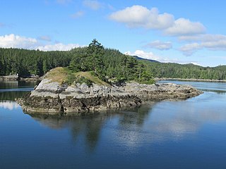
West Redonda Island is an island in British Columbia, Canada. It is part of the Discovery Islands, an archipelago between Vancouver Island and the mainland, and between the Strait of Georgia and Johnstone Strait.
Cordero Channel is a strait in British Columbia, Canada, located between the mainland and Vancouver Island, among the Discovery Islands north of the Strait of Georgia. Cordero Channel runs north of Sonora Island, East Thurlow Island, and part of West Thurlow Island. Its eastern end connects to the mouth of Bute Inlet and to Calm Channel, at Stuart Island. Its west end is marked by the mouth of Loughborough Inlet, beyond which the channel is called Chancellor Channel, which continues west to Johnstone Strait.

Sutil Channel is a broad strait located in the Discovery Islands of British Columbia, Canada.

Skidegate Channel is a strait located in the Haida Gwaii archipelago of British Columbia, Canada. It divides the archipelago's two main islands, Graham Island to the north and Moresby Island to the south.

Fitz Hugh Sound, sometimes spelled Fitzhugh Sound, is a sound on the British Columbia Coast of Canada, located between Calvert Island and the mainland.

Chatham Sound is a sound on the North Coast of British Columbia, Canada, bordering on Alaska, United States. It is located between the Dundas and Stephens Islands and the Tsimpsean Peninsula, it is part of the Inside Passage and extends from Portland Inlet in the north to Porcher Island in the south.
The Southgate River is a river in the Pacific Ranges of the Coast Mountains in British Columbia, Canada, entering the head of Bute Inlet, on that province's South Coast, just east of the mouth of the Homathko River at Waddington Harbour. The lower reaches of the river's course are flat-bottomed and are named Pigeon Valley.

Skidegate Inlet is a broad inlet on the east coast of the Haida Gwaii archipelago of the North Coast of British Columbia, Canada. It is the easternmost of a series of waterways separating Graham Island to the north from Moresby Island to the south.
Kiltuish River is a river in the Canadian province of British Columbia. It originates in the Kitimat Ranges, and flows about 25 km (16 mi) north to the Pacific Ocean at Kiltuish Inlet, an arm of the fjord Gardner Canal. The Kiltuish River is within the traditional territory of the Haisla people.
Lewis Channel is a strait located between Cortes Island and West Redonda Island in the Discovery Islands of British Columbia, Canada. It is part of the northern Salish Sea.
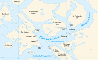
Homfray Channel is a deep water channel, reaching depths of 731 meters, located between East Redonda and the mainland coast of British Columbia, Canada.