The Strait of Georgia or the Georgia Strait is an arm of the Salish Sea between Vancouver Island and the extreme southwestern mainland coast of British Columbia, Canada, and the extreme northwestern mainland coast of Washington, United States. It is approximately 240 kilometres (150 mi) long and varies in width from 20 to 58 kilometres. Along with the Strait of Juan de Fuca and Puget Sound, it is a constituent part of the Salish Sea.

Quadra Island is a large island off the eastern coast of Vancouver Island, in British Columbia, Canada. It is part of the Discovery Islands, in the Strathcona Regional District.

The Regional District of Comox-Strathcona was a regional district of British Columbia, Canada, from 1967 to 2008. On February 15, 2008, the regional district was abolished and replaced by two successor regional districts, Comox Valley and Strathcona.
Texada Island is a large island located in the Strait of Georgia of British Columbia, Canada. With an area of 300.45 km2 (116.00 sq mi), it is the largest island of the Gulf Islands and the third largest island in the Strait of Georgia after Whidbey Island in Washington and Quadra Island of the Discovery Islands. Once a major mining and logging centre home to a fairly large population, Texada's industry has largely disappeared and its population shrunk since the decline began in the 1950s. In the present, it is mostly recognized as an out-of-the-way cottage and camping destination known for its warm waters and scenic beaches.

Desolation Sound is a deep water sound at the northern end of the Salish Sea and of the Sunshine Coast in British Columbia, Canada.
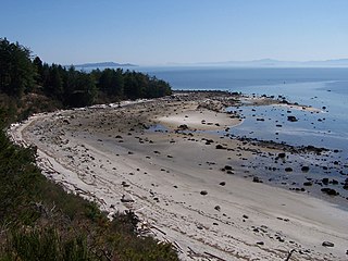
Savary Island or Áyhus is an island in British Columbia, Canada. Located in the northern part of the Strait of Georgia, it is 144 kilometres (89 mi) northwest of Vancouver. It is approximately 0.8-1.5 km wide and 7.5 kilometres (4.7 mi) long. It has a permanent population of about 100, expanding to perhaps 2,000 or more in the summer months. Savary Island lies within the traditional territory of the Tla'amin Nation.

Cortes Island is an island in the Discovery Islands archipelago on the coast of British Columbia, Canada. The island is 25 km (16 mi) long, 13 km (8 mi) wide, and 130 km2 (50 sq mi) in area. It has a population of 1,035 permanent residents. Cortes Island lies within Electoral Area B of the Strathcona Regional District, which provides water and sewage systems, fire protection, land use planning, parks, recreation, and emergency response.

Sonora Island is one of the outer islands of the Discovery Islands of British Columbia, Canada. It is located at the eastern end of Johnstone Strait and the northern end of Discovery Passage within Electoral Area C of the Strathcona Regional District.

Johnstone Strait is a 110 km (68 mi) channel along the north east coast of Vancouver Island in British Columbia, Canada. Opposite the Vancouver Island coast, running north to south, are Hanson Island, West Cracroft Island, the mainland British Columbia Coast, Hardwicke Island, West Thurlow Island and East Thurlow Island. At that point, the strait meets Discovery Passage which connects to Georgia Strait.

The Vancouver Expedition (1791–1795) was a four-and-a-half-year voyage of exploration and diplomacy, commanded by Captain George Vancouver of the Royal Navy. The British expedition circumnavigated the globe and made contact with five continents. The expedition at various times included between two and four vessels, and up to 153 men, all but 6 of whom returned home safely.
The ƛoʔos Klahoose are one of the three groups comprising the ʔayʔaǰuθəm Tla'Amin or Mainland Comox. The other two divisions of this once-populous group are the χʷɛmaɬku Homalco and Sliammon. The Klahoose, Homalco and Sliammon are, according to oral tradition, the descendants of the survivors of the Great Flood. The three groups were split by colonialism into different band councils but united historically as the Tla A'min, known as the Mainland Comox, and K’ómoks, the larger grouping of the Comox people, also known as the Island Comox and before the merger with the Laich-kwil-tach culture. Historically both groups are a subgroup of the Coast Salish though the K’ómoks name is from, and their language today, is the Lik'wala dialect of Kwak'wala. The ancestral tongue is the Comox language, though the Sahtloot/Island dialect is extinct.

Maurelle Island is an island in British Columbia, Canada. It is part of the Discovery Islands between Vancouver Island and the mainland, between the Strait of Georgia and Johnstone Strait.

West Redonda Island is an island in British Columbia, Canada. It is part of the Discovery Islands, an archipelago between Vancouver Island and the mainland, and between the Strait of Georgia and Johnstone Strait.

West Thurlow Island is an island in British Columbia, Canada. It is part of the Discovery Islands, an archipelago between Vancouver Island and the mainland, whose waters connect the Strait of Georgia with Johnstone Strait and Queen Charlotte Strait.

East Thurlow Island is an island in British Columbia, Canada. It is part of the Discovery Islands, an archipelago between Vancouver Island and the mainland, whose waters connect the Strait of Georgia with Johnstone Strait and Queen Charlotte Strait. East Thurlow Island is located north of Vancouver Island, south of the mainland, northwest of Sonora Island, and east of West Thurlow Island. East Thurlow Island is located within Electoral Area C of the Strathcona Regional District.
Cordero Channel is a strait in British Columbia, Canada, located between the mainland and Vancouver Island, among the Discovery Islands north of the Strait of Georgia. Cordero Channel runs north of Sonora Island, East Thurlow Island, and part of West Thurlow Island. Its eastern end connects to the mouth of Bute Inlet and to Calm Channel, at Stuart Island. Its west end is marked by the mouth of Loughborough Inlet, beyond which the channel is called Chancellor Channel, which continues west to Johnstone Strait.

Read Island is an island in British Columbia, Canada. It is part of the Discovery Islands between Vancouver Island and the mainland, between the Strait of Georgia and Johnstone Strait.

The Rendezvous Islands are a group of islands in British Columbia, Canada. They are part of the Discovery Islands between Vancouver Island and the mainland, between the Strait of Georgia and Johnstone Strait.
Raza Island is an island in British Columbia, Canada. It is part of the Rendezvous Islands in Calm Channel, which in turn are part of the Discovery Islands between Vancouver Island and the mainland, between the Strait of Georgia and Johnstone Strait.
The New Westminster Land District is one of 59 land districts of British Columbia, Canada, which are the underlying cadastral divisions of that province, created with rest of those on Mainland British Columbia via the Lands Act of the Colony of British Columbia in 1860. The British Columbia government's BC Names system, a subdivision of GeoBC, defines a land district as "a territorial division with legally defined boundaries for administrative purposes". All land titles and surveys use the Land District system as the primary point of reference, and entries in BC Names for placenames and geographical objects are so listed.