Related Research Articles

The Peace River is a 1,923-kilometre-long (1,195 mi) river in Canada that originates in the Rocky Mountains of northern British Columbia and flows to the northeast through northern Alberta. The Peace River joins the Athabasca River in the Peace-Athabasca Delta to form the Slave River, a tributary of the Mackenzie River. The Finlay River, the main headwater of the Peace River, is regarded as the ultimate source of the Mackenzie River. The combined Finlay–Peace–Slave–Mackenzie river system is the 13th longest river system in the world.

The Regional District of Bulkley–Nechako (RDBN) is a regional district in the Canadian province of British Columbia, Canada. As of the 2016 census, the population was 37,896. The area is 73,419.01 square kilometres. The regional district offices are in Burns Lake.
Cariboo was a federal electoral district in British Columbia, Canada, that was represented in the House of Commons of Canada from 1871 to 1892.

Williston Lake is a reservoir created by the W. A. C. Bennett Dam and is located in the Northern Interior of British Columbia, Canada.

The Peace River Regional District is a regional district in northeastern British Columbia, Canada. The regional district comprises seven municipalities and four electoral areas. Its member municipalities are the cities of Fort St. John and Dawson Creek, the district municipalities of Tumbler Ridge, Chetwynd, Taylor, and Hudson's Hope, and the village of Pouce Coupe. The district's administrative offices are in Dawson Creek.
Cariboo was one of the twelve original electoral districts created when British Columbia became a Canadian province in 1871. Roughly corresponding to the old colonial electoral administrative district of the same name, it was a three-member riding until the 1894 election, when it was reduced through reapportionment and became a two-member riding until the 1916 election, after which it has been a single-member riding. It produced many notable Members of the Legislative Assembly (MLAs), including George Anthony Boomer Walkem, third and fifth holder of the office of Premier of British Columbia and who was one of the first representatives elected from the riding; John Robson, ninth Premier of British Columbia; and Robert Bonner, a powerful minister in the W.A.C. Bennett cabinet, and later CEO of MacMillan Bloedel and BC Hydro.
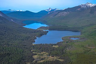
Thutade Lake is located in the Omineca Mountains of the Northern Interior of British Columbia, Canada. About 40 km (25 mi) in length, and no more than about 2 km (1.2 mi) wide, the lake is primarily significant as the ultimate source of the Mackenzie River. The lake is at the head of the Finlay River, which joins the Peace River via Williston Lake. The area is very remote, being located about 260 km (160 mi) north of Smithers, although several mining operations for ores containing copper, lead, zinc and silver have occurred around the lake. The largest of these is the Kemess Mine, an iron and copper property originally owned by Royal Oak Mines and now by Northgate Minerals, located in the valley of Kemess Creek, which is off the northeast end of Thutade Lake. The mine is accessed by the Omineca Resource Road and other resource routes, and is 400 km (250 mi) by road from Prince George. Just downstream from the outlet of Thutade Lake, the Finlay plunges over the 180-foot (55 m) Cascadero Falls, and then through a series of cataracts in a twisting course until it begins its main northeastward trend. Cascadero Falls is slated for hydroelectric development in connection with the power needs of the area's mines.

Kwadacha, also known as Fort Ware or simple Ware, is an aboriginal community in northern British Columbia, Canada, located in the Rocky Mountain Trench at the confluence of the Finlay, Kwadacha and Fox Rivers, in the Rocky Mountain Trench upstream from the end of the Finlay Reach of Williston Lake. The population is about 350. It is in the federal electoral riding of Prince George-Peace River.
The Omineca Mountains, also known as "the Ominecas", are a group of remote mountain ranges in the Boreal Cordillera of north-central British Columbia, Canada. They are bounded by the Finlay River on the north, the Rocky Mountain Trench on the east, the Nation Lakes on the south, and the upper reaches of the Omineca River on the west. They form a section of the Continental Divide, that, in this region, separates water drainage between the Arctic and Pacific Oceans. The lower course of the Omineca River flows through the heart of the range. To the south of the Ominecas is the Nechako Plateau, to the west the Skeena Mountains and Hazelton Mountains, to the north the Spatsizi Plateau and the Stikine Ranges, while east across the Rocky Mountain Trench are the Muskwa Ranges.
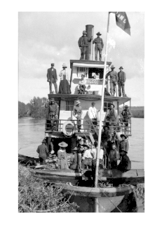
Twelve paddlewheel steamboats plied the upper Fraser River in British Columbia from 1863 until 1921. They were used for a variety of purposes: working on railroad construction, delivering mail, promoting real estate in infant townsites and bringing settlers in to a new frontier. They served the towns of Quesnel, Barkerville and Fort George. Some only worked the Fraser from Soda Creek to Quesnel, while others went all the way to Tête Jaune Cache or took the Nechako River and served Fort Fraser and beyond.

The British Columbia Interior, popularly referred to as the BC Interior or simply the Interior, is a geographic region of the Canadian province of British Columbia. While the exact boundaries are variously defined, the British Columbia Interior is generally defined to include the 14 regional districts that do not have coastline along the Pacific Ocean or Salish Sea, and are not part of the Lower Mainland. Other boundaries may exclude parts of or even entire regional districts, or expand the definition to include the regional districts of Fraser Valley, Squamish–Lillooet, and Kitimat–Stikine.
The Lillooet Country, also referred to as the Lillooet District, is a region spanning from the central Fraser Canyon town of Lillooet west to the valley of the Lillooet River, and including the valleys in between, in the Southern Interior of British Columbia. Like other historical BC regions, it is sometimes referred to simply as The Lillooet or even Lillooet,.

The Stikine Country, also referred to as the Stikine District or simply "the Stikine", is one of the historical geographic regions of the Canadian province of British Columbia, located inland from the central Alaska Panhandle and comprising the basin of the Stikine River and its tributaries. The term Stikine–Iskut is also fairly common to describe the area, and references the Iskut River, the Stikine's largest tributary and describable as its south fork.
The Nechako Country, also referred to as the Nechako District or simply "the Nechako" is one of the historical geographic regions of the Canadian province of British Columbia, located southwest of the city of Prince George and south of Hwy 16 on the inland side of the Hazelton Mountains, and comprising the basin of the Nechako River and its tributaries. "Nechako" is an anglicization of netʃa koh, its name in the indigenous Carrier language which means "big river".
The Omineca Gold Rush was a gold rush in British Columbia, Canada in the Omineca region of the Northern Interior of the province. Gold was first discovered there in 1861, but the rush didn't begin until late in 1869 with the discovery at Vital Creek. There were several routes to the goldfields: two were from Fort St. James, one of which was a water route through the Stuart and Tachie Rivers to Trembleur Lake to Takla Lake and the other was overland, called the Baldy Mountain route. A third route came in overland from Hazelton on the Skeena River and a fourth route used the Fraser River and crossed over the Giscome Portage to Summit Lake, through McLeod Lake, and up the Finlay River to the Omineca River.
The Cassiar Country, also referred to simply as the Cassiar, is a historical geographic region of the Canadian province of British Columbia. The Cassiar is located in the northwest portion of British Columbia, just to the northeast of the Stikine Country, while to the south is the Omineca Country. The area is noted for the Cassiar gold rush of the 1870s, when Laketon became its unofficial capital. The ghost town of Cassiar is also located in the Cassiar region.

Frank Cyril Swannell was one of British Columbia's most famous surveyors.
Henry "Harry" McDame was a Bahamas-born prospector in the California and British Columbia gold rushes.
Thomas Creek may refer to:
Omineca Provincial Park and Protected Area is a provincial park and protected area located in the north-central interior of British Columbia, Canada. It was established on 11 April 2001 by BC Parks to protect provincially significant riparian and wetland habitats along the Omineca River.
References
| | This article about a location in the Interior of British Columbia, Canada is a stub. You can help Wikipedia by expanding it. |