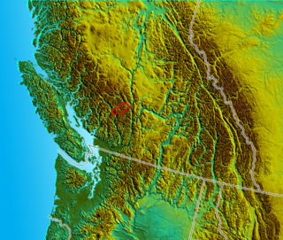
The Lillooet Country, also referred to as the Lillooet District, is a region spanning from the central Fraser Canyon town of Lillooet west to the valley of the Lillooet River, and including the valleys in between, in the Southern Interior of British Columbia. Like other historical BC regions, it is sometimes referred to simply as The Lillooet or even Lillooet, (i.e. without meaning the town of the same name).
The meaning of the name has changed since over time. During the gold rush and into the later 19th Century, the term Lillooet District was synonymous with the Lillooet Mining District and also the Lillooet Land District, which spanned east of the Fraser all the way to the North Thompson River. As development of that region proceeded the sense of "Lillooet District" for that area was abandoned, except in terms of reference to the Land District or the similarly shaped electoral district.
The original Lillooet Country, or "Old Lillooet", lies in the valley of the Lillooet River, the name of which is derived from the St'at'imcets-speaking First Nations people who live there, the Lil'wat-ul. This isolated region, long dependent on Lillooet and on the old Douglas Road and Pemberton Trail routes to the outside world, continued being considered part of the Lillooet Country until after the opening of Hwy 99 from Pemberton via Squamish to North Vancouver, since which time it has slowly become more identified with the modern-era Sea to Sky Corridor. Though largely not considered as "part of the Lillooet Country" nowadays, the Lillooet River valley is the namesake and origin of the concept of the Lillooet Country. Its point-of-access in gold rush times was Port Lillooet, British Columbia, at the south end of Lillooet Lake.
Also part of the Lillooet Country are the valleys between those of the Fraser and the Lillooet Rivers, namely the valleys of the Bridge River, Birkenhead River, Cayoosh Creek and Seton Lake-Anderson Lake-Gates River valley, which is the route of the Canadian National Railway (formerly PGE/BCR) through the district. The basin of the Bridge River, plus the communities of D'Arcy, McGillivray Falls, Seton Portage and Shalalth are collectively known as the Bridge River Country, which is a subarea of the Lillooet Country. After the 1930s the term "Bridge River-Lillooet" came into currency as a result of the chosen masthead of the fledgling Bridge River-Lillooet News, which served the town and environs of Lillooet as well as the mining towns of the upper Bridge River.
The Lillooet Country's boundaries are loosely defined but recognizable to residents of the area. On the northeast, the edge of the Lillooet Country is marked by the summit of the Pavilion Mountain Road and the nearby eastern outlet of Marble Canyon. Down the Fraser Canyon, a spot known as the Big Slide on Highway 12, or the southern outlet of Fountain Valley, form the southwest boundary. On the northwest generally everything north to Churn Creek and Big Bar Ferry is considered to be Lillooet Country. On the west, generally the summit of Cayoosh Pass on Highway 99 near Duffey Lake is recognizable as a "border" of the "modern" meaning of the Lillooet Country. Similarly, Pemberton Pass at Birken Lake is considered to be the outer boundary of the "modern" Lillooet Country, though as noted the Lillooet River valley to its west was the historic core and namesake of the district. Similarly, the entrance to the Bridge River Country via Railroad Pass (aka Railway Pass) between the upper Hurley River and the upper valley of the Lillooet River is a recognizable regional demarcator for locals. A vague distinction is made between the Bridge River Country and "metropolitan Lillooet" such that the lower few miles of the Bridge River, being effectively part of Greater Lillooet, are considered "Lillooet", whereas above that is "in the Bridge River".
Lillooet, formerly Cayoosh Flat, is a community on the Fraser River in British Columbia, Canada, about 240 kilometres (150 mi) up the British Columbia Railway line from Vancouver. Situated at an intersection of deep gorges in the lee of the Coast Mountains, it has a dry climate with an average of 329.5 millimetres (13 in) of precipitation being recorded annually. Lillooet has a long growing season, and once had prolific market gardens and orchard produce. It often vies with Lytton and Osoyoos for the title of "Canada's Hot Spot" on a daily basis in summer.
The St'at'imc, also known as the Lillooet, St̓át̓imc, Stl'atl'imx, etc., are an Interior Salish people located in the southern Coast Mountains and Fraser Canyon region of the Interior of the Canadian province of British Columbia.
The Squamish-Lillooet Regional District is a quasi-municipal administrative area in British Columbia, Canada. It stretches from Britannia Beach in the south to Pavilion in the north. Lillooet, Pemberton, Whistler and Squamish are the four municipalities in the regional district. Its administrative offices are in the Village of Pemberton, although the district municipalities of Squamish, Whistler, and Lillooet are all larger population centres. The district covers 16,353.68 km² of land area.
Seton Portage is a historic rural community in British Columbia, Canada, that is about 25 km (16 mi) west of Lillooet, located between Seton Lake and Anderson Lake. "The Portage" was formed about 10,000 years ago when the flank of the Cayoosh Range, which is the south flank of the valley, let go and slid into the middle of what had been a single lake. The result is a location similar to Interlaken, Switzerland, with two fjord-style lakes flanking a narrow and very short strip of land between them.
The Fraser Canyon is a major landform of the Fraser River where it descends rapidly through narrow rock gorges in the Coast Mountains en route from the Interior Plateau of British Columbia to the Fraser Valley. Colloquially, the term "Fraser Canyon" is often used to include the Thompson Canyon from Lytton to Ashcroft, since they form the same highway route which most people are familiar with, although it is actually reckoned to begin above Williams Lake, British Columbia at Soda Creek Canyon near the town of the same name.
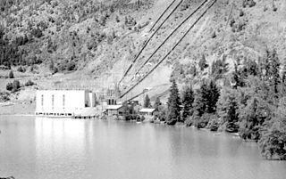
Shalalth, pop. c. 400, is one of the main communities of the Seton Lake Band of the St'at'imc (Lillooet) Nation and location of the two main powerhouses of the Bridge River Power Project.
The Lillooet Ranges are the southeasternmost subdivision of the Pacific Ranges of the Coast Mountains of British Columbia. They are located between the drainage of the Lillooet River and Harrison Lake on the west and the canyon of the Fraser River on the east, and by the lowland coastal valley of that river on the south.
Seton Lake is a freshwater fjord draining east via the Seton River into the Fraser River at the town of Lillooet, about 22 km (14 mi) long, 26.2 km2 (10.1 sq mi) in area and lies at an elevation of 243 m (797 ft). Its depth is 460 m (1,500 ft).
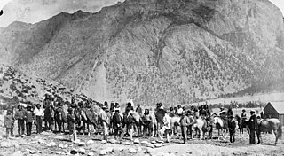
The Douglas Road, a.k.a. the Lillooet Trail, Harrison Trail or Lakes Route, was a goldrush-era transportation route from the British Columbia Coast to the Interior. Over 30,000 men are reckoned to have travelled the route in, although by the end of the 1860s it was virtually abandoned due to the construction of the Cariboo Wagon Road, which bypassed the region.
Anderson Lake is located about 25 miles North of the town of Pemberton, British Columbia and is about 28.5 km² in area and around 21 km (13 mi) in length. Its maximum depth is 215 meters. It is drained by the Seton River, which feeds Seton Lake and so the Fraser River. It is fed by the Gates River, which drains from the Pemberton Pass divide with the Birkenhead River valley towards Pemberton-Mount Currie.
The Cayoosh Range is the northernmost section of the Lillooet Ranges, which are a subrange of the Pacific Ranges of the Coast Mountains in British Columbia, Canada. The range covers an area of c. 3770 km² and is approximately 65 km (40 mi) SW to NE and about 20 km (12 mi) SE to NW.
The Bridge River Power Project is a hydroelectric power development in the Canadian province of British Columbia, located in the Lillooet Country between Whistler and Lillooet. It harnesses the power of the Bridge River, a tributary of the Fraser, by diverting it through a mountainside to the separate drainage basin of Seton Lake, utilizing a system of three dams, four powerhouses and a canal.
The British Columbia Interior, BC Interior or Interior of British Columbia, usually referred to only as the Interior, is one of the three main regions of the Canadian province of British Columbia, the other two being the Lower Mainland, which comprises the overlapping areas of Greater Vancouver and the Fraser Valley, and the Coast, which includes Vancouver Island and also including the Lower Mainland.
Bridge River was used to describe three separate towns or localities in the Lillooet Country of the Interior of British Columbia connected with the river and valley of the same name.
The Bridge River Country is a historic geographic region and mining district in the Interior of British Columbia, Canada, lying between the Fraser Canyon and the valley of the Lillooet River, south of the Chilcotin Plateau and north of the Lillooet Ranges. "The Bridge River" can mean the Bridge River Country as opposed to the Bridge River itself, and is considered to be part of the Lillooet Country, but has a distinct history and identity within the larger region. As Lillooet is sometimes considered to be the southwest limit of the Cariboo, some efforts were made to refer to the Bridge River as the "West Cariboo" but this never caught on.
The Lakes Route is an alternate name for the Douglas Road, which was the first formally designated "road" into the Interior of British Columbia, Canada from its Lower Mainland area flanking the Lower Fraser River. Also known as the Douglas-Lillooet Trail or the Lillooet Trail, the route consisted of a series of wagon roads connected via lake travel in between. A variety of craft were used on the lakes, from steamboats to sail-driven rafts to, through the early 20th Century, diesel and other engines. Lake travel continued for commerce, passenger travel and heavy freight until after World War II.
Cayoosh Pass is a mountain pass in the Lillooet Ranges of the Pacific Ranges of the southern Coast Mountains in British Columbia, Canada. It lies just west of Duffey Lake on BC Highway 99 between the towns of Lillooet and Pemberton, formed by the headwaters of Cayoosh Creek to the east, flowing to the Fraser River at Lillooet, and Joffre Creek to the west, flowing steeply downhill to Lillooet Lake just southeast of the Mount Currie Indian Reserve.
Pemberton Pass, 505 m (1,657 ft), also formerly known as Mosquito Pass, is the lowest point on the divide between the Lillooet and Fraser River drainages, located at Birken, British Columbia, Canada, in the principal valley connecting and between Pemberton and Lillooet. The pass is a steep-sided but flat-bottomed valley adjacent to Mount Birkenhead and forming a divide between Poole Creek, a tributary of the Birkenhead River, which joins the Lillooet at Lillooet Lake, and the Gates River which flows northeast from Gates Lake, at the summit of the pass, which flows to the Fraser via Anderson and Seton Lakes and the Seton River.
Cayoosh Creek is a northeast-flowing tributary of the Seton River in the Canadian province of British Columbia. The name Cayoosh Creek remains on the bridge-sign crossing the stream on BC Highway 99 and continues in use locally to refer to the final reaches of the Seton River, formerly Seton Creek, which prior to the renaming ending at the confluence with Cayoosh Creek. The creek is the namesake of Cayoosh Creek Indian Reserve No. 1, one of the main Indian reserves of the Cayoose Creek Indian Band, which lies adjacent to what was renamed the Seton River without local consultation.
Mission Ridge, also known as Mission Mountain, is a ridge in the Bridge River-Lillooet Country of the South-Central Interior of British Columbia, Canada, extending westward from the town of Lillooet along the north side of Seton Lake to Mission Pass, which is immediately above and to the north of the lakeside community of Shalalth. The road over the pass is also known as Mission Mountain, which is short for "Mission Mountain Road". Mission Creek lies on the north side of the pass, and is a tributary of the Bridge River, the lower reaches of which lie on the north side of the ridge, and which was the only road access into the upper Bridge River Country before the construction of a road through the Bridge River Canyon in the mid-1950s opened that region up to road access from the lower Bridge River valley and the town of Lillooet via the community or Moha. Most, or virtually all, of the ridge, is Indian Reserves, notably Slosh 1, under the administration of the Seton Lake Indian Band, and Bridge River 1, which is under the administration of the Bridge River Indian Band. Parts of the ridge's eastern end are in reserves controlled by the Lillooet Indian Band, including its final spires above Lillooet, which were dubbed St. Mary's Mount by the Reverend Lundin Brown in the 1860s, though that name never stuck and is ungazetted.
This page is based on this Wikipedia article Text is available under the CC BY-SA 4.0 license; additional terms may apply. Images, videos and audio are available under their respective licenses.