The Fraser River is the longest river within British Columbia, Canada, rising at Fraser Pass near Blackrock Mountain in the Rocky Mountains and flowing for 1,375 kilometres (854 mi), into the Strait of Georgia just south of the City of Vancouver. The river's annual discharge at its mouth is 112 cubic kilometres (27 cu mi) or 3,550 cubic metres per second (125,000 cu ft/s), and each year it discharges about 20 million tons of sediment into the ocean.
The Stʼatʼimc, also known as the Lillooet, St̓át̓imc, Stl'atl'imx, etc., are an Interior Salish people located in the southern Coast Mountains and Fraser Canyon region of the Interior of the Canadian province of British Columbia.
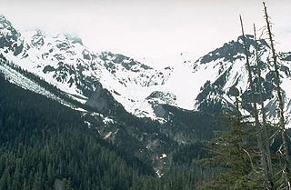
The Chehalis River is located in the southwest corner of British Columbia, Canada near the city of Chilliwack. It flows south-eastward out of the Douglas Ranges of the Coast Mountains, draining into the Harrison River.

Lillooet Lake is a lake in British Columbia, Canada about 25 km in length and about 33.5 square kilometres (22 mi²) in area. It is about 95 km downstream from the source of the Lillooet River, which resumes its course after leaving Little Lillooet Lake, aka Tenas Lake. Immediately adjacent to the mouth of the upper Lillooet River is the mouth of the Birkenhead River and just upstream along the Lillooet is the confluence of the Green River, which begins at Green Lake in the resort area of Whistler.

The Lillooet Ranges are the southeasternmost subdivision of the Pacific Ranges of the Coast Mountains of British Columbia. They are located between the drainage of the Lillooet River and Harrison Lake on the west and the canyon of the Fraser River on the east, and by the lowland coastal valley of that river on the south.

The Pacific Ranges are the southernmost subdivision of the Coast Mountains portion of the Pacific Cordillera. Located entirely within British Columbia, Canada, they run northwest from the lower stretches of the Fraser River to Bella Coola and Burke Channel, north of which are the Kitimat Ranges. The Coast Mountains lie between the Interior Plateau and the Coast of British Columbia.
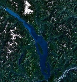
Harrison Lake is the largest lake in the southern Coast Mountains of Canada, being about 250 square kilometres (95 mi²) in area. It is about 60 km (37 mi) in length and at its widest almost 9 km (5.6 mi) across. Its southern end, at the resort community of Harrison Hot Springs, is c. 95 km east of downtown Vancouver. East of the lake are the Lillooet Ranges while to the west are the Douglas Ranges. The lake is the last of a series of large north-south glacial valleys tributary to the Fraser along its north bank east of Vancouver, British Columbia. The others to the west are the Chehalis, Stave, Alouette, Pitt, and Coquitlam Rivers.
The Birkenhead River, formerly known as the Portage River, the Pole River and the Mosquito River, is a major tributary of the Lillooet River, which via Harrison Lake and the Harrison River is one of the major tributaries of the lower Fraser River. It is just over 50 km long from its upper reaches in the unnamed ranges south of Bralorne, British Columbia ; their western area towards the named Bendor Range east of Bralorne is sometimes called the Cadwallader Ranges.
Keyhole Falls is the unofficial name for the largest waterfall along the Lillooet River in British Columbia, Canada. The falls are 115 feet (35 m) high and are a punchbowl type of waterfall.
The Taseko River or Dasiqox in the original Chilcotin, is a tributary of British Columbia's Chilko River, a tributary of the Chilcotin River which joins the Fraser near the city of Williams Lake.

The Mount Meager massif is a group of volcanic peaks in the Pacific Ranges of the Coast Mountains in southwestern British Columbia, Canada. Part of the Cascade Volcanic Arc of western North America, it is located 150 km (93 mi) north of Vancouver at the northern end of the Pemberton Valley and reaches a maximum elevation of 2,680 m (8,790 ft). The massif is capped by several eroded volcanic edifices, including lava domes, volcanic plugs and overlapping piles of lava flows; these form at least six major summits including Mount Meager which is the second highest of the massif.
The Lillooet Icecap, also called the Lillooet Icefield or the Lillooet Crown, is a large icefield in the Pacific Ranges of the Coast Mountains in southwestern British Columbia, Canada. It is about 90 km (56 mi) northwest of the towns of Pemberton and Whistler, and about 175 km (109 mi) north of Vancouver, British Columbia. The Lillooet Icecap is one of the largest of several large icefields in the Pacific Ranges which are the largest temperate-latitude glacial fields in the world. At its maximum extent including its glacial tongues it measures 30 km (19 mi) east to west and 20 km (12 mi) north to south; its central icefield area is approximately 15 km (9 mi) in diameter.
Skatin is a community of under 100 persons in Skatin First Nations, aka the Skatin Nations, a Band government of the larger Band of the In-SHUCK-ch Nation, part of the St'at'imc people who are also referred to as Lower Stl'atl'imx. Skatin, the official new name, reverts to the traditional pre-colonial/pre-Columbian name. The alternate past name still commonly used by outsiders, Skookumchuck, is the St'at'imcets version of the Chinook Jargon Skookumchuck, meaning Strong Waters, i.e. rapids. The town site is 4 km south of T'sek Hot Spring, formerly named both Saint Agnes Well and Skookumchuck Hot Springs. The community is 28 km south of the outlet of Lillooet Lake on the east side of the Lillooet River. It is approximately 75 km south of the town of Pemberton and the large reserve of the Lil'wat branch of the St'at'imc at Mount Currie, British Columbia. See Skatin First Nations for details about the complicated Band(s) structure.

Meager Creek is a creek in the southern Pacific Ranges of the Coast Mountains in British Columbia, Canada. It flows northeast into the Lillooet River approximately 95 km (59 mi) northwest of the village of Pemberton and is adjacent to the Upper Lillooet Provincial Park.

The Alouette River is a tributary of the Pitt River in the Canadian province of British Columbia.

Cayoosh Creek is a northeast-flowing tributary of the Seton River in the Canadian province of British Columbia. The name Cayoosh Creek remains on the bridge-sign crossing the stream on BC Highway 99 and continues in use locally to refer to the final reaches of the Seton River, formerly Seton Creek, which prior to the renaming ending at the confluence with Cayoosh Creek. The creek is the namesake of Cayoosh Creek Indian Reserve No. 1, one of the main Indian reserves of the Cayoose Creek Indian Band, which lies adjacent to what was renamed the Seton River without local consultation.

The Canadian Cascade Arc, also called the Canadian Cascades, is the Canadian segment of the North American Cascade Volcanic Arc. Located entirely within the Canadian province of British Columbia, it extends from the Cascade Mountains in the south to the Coast Mountains in the north. Specifically, the southern end of the Canadian Cascades begin at the Canada–United States border. However, the specific boundaries of the northern end are not precisely known and the geology in this part of the volcanic arc is poorly understood. It is widely accepted by geologists that the Canadian Cascade Arc extends through the Pacific Ranges of the Coast Mountains. However, others have expressed concern that the volcanic arc possibly extends further north into the Kitimat Ranges, another subdivision of the Coast Mountains, and even as far north as Haida Gwaii.
The Bridge River Vent is a volcanic crater in the Pacific Ranges of the Coast Mountains in southwestern British Columbia, Canada. It is located 51 km (32 mi) west of Bralorne on the northeastern flank of the Mount Meager massif. With an elevation of 1,524 m (5,000 ft), it lies on the steep northern face of Plinth Peak, a 2,677 m (8,783 ft) high volcanic peak comprising the northern portion of Meager. The vent rises above the western shoulder of the Pemberton Valley and represents the northernmost volcanic feature of the Mount Meager massif.

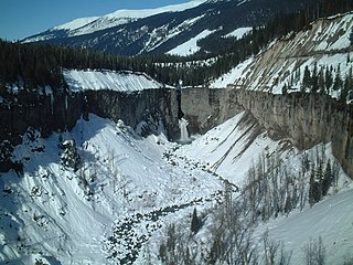
The 2010 Mount Meager landslide was a large catastrophic debris avalanche that occurred in southwestern British Columbia, Canada, on August 6 at 3:27 a.m. PDT (UTC-7). More than 45,000,000 m3 (1.6×10⁹ cu ft) of debris slid down Mount Meager, temporarily blocking Meager Creek and destroying local bridges, roads and equipment. It was one of the largest landslides in Canadian history and one of over 20 landslides to have occurred from the Mount Meager massif in the last 10,000 years.

Mount Meager is a mountain in the Pacific Ranges of the Coast Mountains in British Columbia, Canada. It represents the second highest peak of the Mount Meager massif, a group of coalescent stratovolcanoes in the Garibaldi Volcanic Belt.