
The Fraser River is the longest river within British Columbia, Canada, rising at Fraser Pass near Blackrock Mountain in the Rocky Mountains and flowing for 1,375 kilometres (854 mi), into the Strait of Georgia just south of the City of Vancouver. It is the 11th longest river in Canada. The river's annual discharge at its mouth is 112 cubic kilometres (27 cu mi) or 3,550 cubic metres per second (125,000 cu ft/s), and it discharges 20 million tons of sediment into the ocean.

The Fraser Canyon is a major landform of the Fraser River where it descends rapidly through narrow rock gorges in the Coast Mountains en route from the Interior Plateau of British Columbia to the Fraser Valley. Colloquially, the term "Fraser Canyon" is often used to include the Thompson Canyon from Lytton to Ashcroft, since they form the same highway route which most people are familiar with, although it is actually reckoned to begin above Williams Lake, British Columbia at Soda Creek Canyon near the town of the same name.
The Chilcotin region of British Columbia is usually known simply as "the Chilcotin", and also in speech commonly as "the Chilcotin Country" or simply Chilcotin. It is a plateau and mountain region in British Columbia on the inland lee of the Coast Mountains on the west side of the Fraser River. Chilcotin is also the name of the river draining that region. In the language of the Chilcotin people their name and the name of the river means "people of the red ochre river"

The Nechako River arises on the Nechako Plateau east of the Kitimat Ranges of the Coast Mountains of British Columbia, Canada, and flows north toward Fort Fraser, then east to Prince George where it enters the Fraser River. "Nechako" is an anglicization of netʃa koh, its name in the indigenous Carrier language which means "big river".
Harrison Lake is the largest lake in the southern Coast Mountains of Canada, being about 250 square kilometres (95 mi²) in area. It is about 60 km (37 mi) in length and at its widest almost 9 km (5.6 mi) across. Its southern end, at the resort community of Harrison Hot Springs, is c. 95 km east of downtown Vancouver. East of the lake are the Lillooet Ranges while to the west are the Douglas Ranges. The lake is the last of a series of large north-south glacial valleys tributary to the Fraser along its north bank east of Vancouver, British Columbia. The others to the west are the Chehalis, Stave, Alouette, Pitt, and Coquitlam Rivers.
The Interior Plateau comprises a large region of the Interior of British Columbia, and lies between the Cariboo and Monashee Mountains on the east, and the Hazelton Mountains, Coast Mountains and Cascade Range on the west. The continuation of the plateau into the United States is known there as the Columbia Plateau.
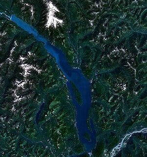
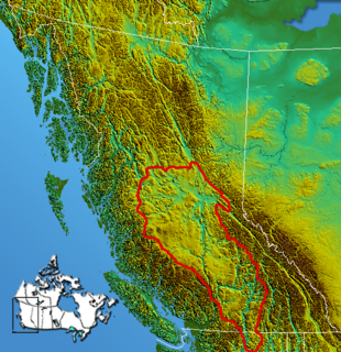
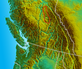
The Chilcotin Plateau is part of the Fraser Plateau, a major subdivision of the Interior Plateau of British Columbia. The Chilcotin Plateau is physically near-identical with the region of the same name, i.e. "the Chilcotin", which lies between the Fraser River and the southern Coast Mountains and is defined by the basin of the Chilcotin River and so includes montane areas beyond the plateau. East of the Chilcotin Plateau, across the Fraser River, is the Cariboo Plateau, while to the north beyond the West Road (Blackwater) River is the Nechako Plateau. West and south of the Chilcotin Plateau are various subdivisions of the Coast Mountains, including the Chilcotin Ranges which lie along the plateau's southwest.
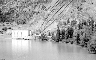
The Bridge River Power Project is a hydroelectric power development in the Canadian province of British Columbia, located in the Lillooet Country between Whistler and Lillooet. It harnesses the power of the Bridge River, a tributary of the Fraser, by diverting it through a mountainside to the separate drainage basin of Seton Lake, utilizing a system of three dams, four powerhouses and a canal.
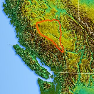
The Nechako Plateau is the northernmost subdivision of the Interior Plateau, one of the main geographic regions of the Canadian province of British Columbia. It spans the basin of the Nechako River and its tributaries the Stuart River and Endako Rivers, and is bounded on the south by the West Road River, south of which is the Chilcotin Plateau and on the north by the Nation River and the valleys of Babine and Takla Lakes, beyond which are the Omineca Mountains (N) and Skeena Mountains (NW). To the west, it abuts the various ranges of the Hazelton Mountains while on its east it is bounded by the pass between Prince George, British Columbia and the Parsnip Arm of Williston Lake, beyond which is the McGregor Plateau, which skirts the Northern Rockies. Some classification systems include the plateau area on the east bank of the Fraser River beyond the city of Prince George; this area neighbours the northernmost reaches of the Quesnel Highland and Cariboo Mountains.

The British Columbia Interior, popularly referred to as the BC Interior or simply the Interior, is a geographic region of the Canadian province of British Columbia. While the exact boundaries are variously defined, the British Columbia Interior is generally defined to include the 14 regional districts that do not have coastline along the Pacific Ocean or Salish Sea, and are not part of the Lower Mainland. Other boundaries may exclude parts of or even entire regional districts, or expand the definition to include the regional districts of Fraser Valley, Squamish–Lillooet, and Kitimat–Stikine.
The Quesnel Highland is a geographic area in the Central Interior of the Canadian province of British Columbia. As defined by BC government geographer in Landforms of British Columbia, an account and analysis of British Columbia geography that is often cited as authoritative, the Highland is a complex of upland hill and plateau areas forming and defined as being the buffer between the Cariboo Plateau and the Cariboo Mountains, as a sort of highland foothills along the eastern edge of the Interior Plateau running southeast from a certain point southeast of the city of Prince George to the Mahood Lake area at the southeast corner of the Cariboo. Beyond Mahood Lake lies another separately classified area dubbed by Holland the Shuswap Highland which spans similar terrain across the North Thompson and Shuswap Lake-Adams River drainage basins, forming a similar upland-area buffer between the Thompson Plateau and the Monashee Mountains. A third area, the Okanagan Highland, extends from the southern end of the Shuswap Highland in the area of Vernon and Enderby in the northern Okanagan region into Washington State, and also abuts the Monashee Mountains.

The Shuswap Highland is a plateau-like hilly area of 14,511 km2 (5,603 sq mi) in British Columbia, Canada. It spans the upland area between the Bonaparte and Thompson Plateaus from the area of Mahood Lake, at the southeast corner of the Cariboo Plateau, southeast towards the lower Shuswap River east of Vernon in the Okanagan.
An electoral redistribution was undertaken in 2008 in British Columbia in a process that began in late 2005 and was completed with the passage of the Electoral Districts Act, 2008 on April 10, 2008. The redistribution modified most electoral boundaries in the province and increased the number of MLAs from 79 to 85. The electoral boundaries created by the redistribution were first used in the 2009 provincial election.
Bridge Creek is a creek in the South Cariboo region of the Interior of British Columbia, Canada. Its meandering course across the Cariboo Plateau is approximately 85 kilometres in length, beginning at Bridge Lake and running roughly westwards to the town of 100 Mile House and from there turning and running northeast to Canim Lake. Below Canim Lake the Canim River connects to Mahood Lake and the short Mahood River to the Clearwater River, which meets the North Thompson at the town of Clearwater.
The Cheslatta River is a tributary of the Nechako River, one of the main tributaries of the Fraser River, in the Canadian province of British Columbia. It flows through the Nechako Plateau. Before the construction of Kenney Dam in the early 1950s the Cheslatta was a minor tributary of the Nechako. Today the Nechako River is dry above the Cheslatta, which provides all its source water.