
The Rocky Mountains, also known as the Rockies, are a major mountain range and the largest mountain system in North America. The Rocky Mountains stretch 3,000 miles in straight-line distance from the northernmost part of western Canada, to New Mexico in the southwestern United States. Depending on differing definitions between Canada and the U.S., its northern terminus is located either in northern British Columbia's Terminal Range south of the Liard River and east of the Trench, or in the northeastern foothills of the Brooks Range/British Mountains that face the Beaufort Sea coasts between the Canning River and the Firth River across the Alaska-Yukon border. Its southernmost point is near the Albuquerque area adjacent to the Rio Grande rift and north of the Sandia–Manzano Mountain Range. Being the easternmost portion of the North American Cordillera, the Rockies are distinct from the tectonically younger Cascade Range and Sierra Nevada, which both lie farther to its west.

The Fraser River is the longest river within British Columbia, Canada, rising at Fraser Pass near Blackrock Mountain in the Rocky Mountains and flowing for 1,375 kilometres (854 mi), into the Strait of Georgia just south of the City of Vancouver. The river's annual discharge at its mouth is 112 cubic kilometres (27 cu mi) or 3,550 cubic metres per second (125,000 cu ft/s), and each year it discharges about 20 million tons of sediment into the ocean.

The Canadian Rockies or Canadian Rocky Mountains, comprising both the Alberta Rockies and the British Columbian Rockies, is the Canadian segment of the North American Rocky Mountains. It is the easternmost part of the Canadian Cordillera, which is the northern segment of the North American Cordillera, the expansive system of interconnected mountain ranges between the Interior Plains and the Pacific Coast that runs northwest–southeast from central Alaska to the Isthmus of Tehuantepec in Mexico.
The Chehalis River is located in the southwest corner of British Columbia, Canada near the city of Chilliwack. It flows south-eastward out of the Douglas Ranges of the Coast Mountains, draining into the Harrison River.

The Purcell Mountains are a mountain range in southeastern British Columbia, Canada. They are a subrange of the Columbia Mountains, which includes the Selkirk, Monashee, and Cariboo Mountains. They are located on the west side of the Rocky Mountain Trench in the area of the Columbia Valley, and on the east side of the valley of Kootenay Lake and the Duncan River. The only large settlements in the mountains are the Panorama Ski Resort and Kicking Horse Resort, adjacent to the Columbia Valley towns of Invermere and Golden, though there are small settlements, such as Yahk and Moyie along the Crowsnest Highway, and residential rural areas dependent on the cities of Creston, Kimberley and Cranbrook, which are located adjacent to the range.
The Nechako River arises on the Nechako Plateau east of the Kitimat Ranges of the Coast Mountains of British Columbia, Canada, and flows north toward Fort Fraser, then east to Prince George where it enters the Fraser River. "Nechako" is an anglicization of netʃa koh, its name in the indigenous Carrier language which means "big river".

The Pitt River in British Columbia, Canada is a large tributary of the Fraser River, entering it a few miles upstream from New Westminster and about 25 km ESE of Downtown Vancouver. The river, which begins in the Garibaldi Ranges of the Coast Mountains, is in two sections above and below Pitt Lake and flows on a generally southernly course. Pitt Lake and the lower Pitt River are tidal in nature as the Fraser's mouth is only a few miles downstream from their confluence.

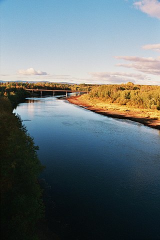
The Rocky Mountain Trench, also known as the Valley of a Thousand Peaks or simply the Trench, is a large valley on the western side of the northern part of North America's Rocky Mountains. The Trench is both visually and cartographically a striking physiographic feature extending approximately 1,600 km (1,000 mi) from Flathead Lake, Montana, to the Liard River, just south of the British Columbia–Yukon border near Watson Lake, Yukon. The trench bottom is 3–16 km (1.9–9.9 mi) wide and is 600–900 m (2,000–3,000 ft) above sea level. The general orientation of the Trench is an almost straight 150/330° geographic north vector and has become convenient as a visual guide for aviators heading north or south.

The Cariboo Mountains are the northernmost subrange of the Columbia Mountains, which run down into the Spokane area of the United States and include the Selkirks, Monashees and Purcells. The Cariboo Mountains are entirely within the province of British Columbia, Canada. The range is 7,700 square kilometres (3,000 sq mi) in area and about 245 km in length (southeast–northwest) and about 90 km at its widest (southwest–northeast).

The Quesnel River is a major tributary of the Fraser River in the Cariboo District of central British Columbia. It begins at the outflow of Quesnel Lake, at the town of Likely and flows for about 100 kilometres (60 mi) northwest to its confluence with the Fraser at the city of Quesnel.

The North American Cordillera, sometimes also called the Western Cordillera of North America, the Western Cordillera or the Pacific Cordillera, is the North American portion of the American Cordillera, the mountain chain system (cordillera) along the western coast of the Americas. The North American Cordillera covers an extensive area of mountain ranges, intermontane basins and plateaus in Western/Northwestern Canada, Western United States and Mexico, including much of the territory west of the Great Plains.

The West Road River or Blackwater River or Tiyakoh is an important tributary of the Fraser River, flowing generally north-eastward from the northern slopes of the Ilgachuz Range and across the Fraser Plateau in the Chilcotin region of central British Columbia, Canada. With only one major tributary, the Nazko River, its confluence with the Fraser is approximately 40 km northwest of Quesnel. It forms the division between the Chilcotin Plateau (S) and the Nechako Plateau (N), which are subdivisions of the Fraser Plateau.

The Premier Range is a group of mountains within the Cariboo Mountains of east-central British Columbia, Canada. The range is bounded by the Raush River and Kiwa Creek to the north, the North Thompson River on the south and west and the Fraser River and its tributaries to the east.

Canoe River is the most northern tributary of the Columbia River in British Columbia, Canada. Its lower reach is flooded by Mica Dam. The lower Canoe River is called Canoe Reach, part of the Mica Dam's reservoir, Kinbasket Lake.

The Doré River is a tributary of the Fraser River in the Canadian province of British Columbia.
The Salmon River is a tributary of the Fraser River in the Central Interior of British Columbia, Canada, flowing southeast to meet that river to the west of Eaglet Lake, to the north of the city of Prince George. The community of Salmon Valley is located in its basin. It was formerly known as the Little Salmon River.
The Morkill River is a tributary of the Fraser River in the Canadian province of British Columbia.
The McKale River is a tributary of the Fraser River in the Canadian province of British Columbia. The river was named in 1913 by surveyor J.A. Walker, after James McKale, a timber cruiser at McBride
The Barrière River is a tributary of the North Thompson River, one of the main tributaries of the Fraser River, in the Canadian province of British Columbia. It flows through the Shuswap Highland region north of Kamloops. Its name in Secwepemctsín is St́yelltsecwétkwe.

Mount McKirdy is a mountain summit in British Columbia, Canada.


