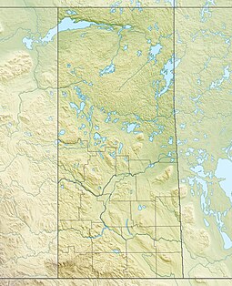
Prince Albert National Park encompasses 3,874 square kilometres (1,496 sq mi) in central Saskatchewan, Canada and is located 200 kilometres (120 mi) north of Saskatoon. Though declared a national park March 24, 1927, official opening ceremonies weren't performed by Prime Minister William Lyon Mackenzie King until August 10, 1928. This park is open all year but the most visited period is from May to September. Although named for the city of Prince Albert, the park's main entrance is actually 80 km (50 mi) north of that city via Highways 2 and 263, which enters the park at its southeast corner. Two additional secondary highways enter the park, Highway 264, which branches off Highway 2 just east of the Waskesiu townsite, and Highway 240, which enters the park from the south and links with 263 just outside the entry fee-collection gates. Prince Albert National Park is not located within any rural municipality, and is politically separate from the adjacent Northern Saskatchewan Administration District (NSAD). Until the establishment of Grasslands National Park in 1981, it was the province's only national park.

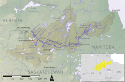
Beaver River is a large river in east-central Alberta and central Saskatchewan, Canada. It flows east through Alberta and Saskatchewan and then turns sharply north to flow into Lac Île-à-la-Crosse on the Churchill River which flows into Hudson Bay.

Peter Pond Lake is a glacial lake in the north-western part of the Canadian province of Saskatchewan. It is located in the boreal orest and Canadian Shield within the Churchill River drainage basin.
Montreal Lake is a lake in the north-central part of Canadian province of Saskatchewan. It is the source of the Montreal River and is located between Highways 2 and 969. Prince Albert National Park is to the west and Clarence-Steepbank Lakes Provincial Park is to the east. Communities on the lake include Montreal Lake, Timber Bay, and Molanosa.

Montreal River is a river in the Canadian province of Saskatchewan. It flows 100 kilometres (62 mi) from Montreal Lake to Lac la Ronge and is part of the Churchill River and Hudson Bay drainage basins. Along its course, Montreal River runs through boreal forests, muskeg, and glacier formed valleys. Within its watershed are the Waskesiu Uplands, much of Prince Albert National Park, and several notable lakes, such as Waskesiu, Kingsmere, Crean, Weyakwin, and Bittern.

Sturgeon River is a river in the Hudson Bay drainage basin in the central part of the Canadian province of Saskatchewan. It flows from its source in the Waskesiu Hills in Prince Albert National Park to the North Saskatchewan River, just west of the city of Prince Albert.

Waterhen River is an east-flowing river in the north-west area of the Canadian province of Saskatchewan in the drainage basin of the Beaver River. It is north of and parallel to the east-flowing part of the Beaver River and joins the north-flowing part of that river. Most of the river and its drainage basin is at the southern edge of the boreal forest belt. While the river's source is Lac des Îles, its drainage basin reaches north into the Mostoos Hills and west well into the neighbouring province of Alberta.
The Cub Hills are a hilly plateau located south-east of the geographical centre of the Canadian province of Saskatchewan. The hills are in the boreal forest ecozone of Canada and the landforms of the hills were shaped more than 10,000 years ago during last ice age. Throughout the Cub Hills, there are dozens of lakes and rivers and several parks. The Cubs Hills are 150 km (93 mi) north-east of Prince Albert and are in the Northern Saskatchewan Administration District and Census Division #18. Several highways criss-cross the plateau to provide access to the various parks and other amenities.

Piwei River is a river in the east-central part of the Canadian province of Saskatchewan in the boreal forest ecozone of Canada. It begins at the western end of the Porcupine Hills at Piwei Lakes and heads in an easterly direction through a glacier-formed valley and into the Etomami River, which is a tributary of the Red Deer River.
Woody River is a river in the Canadian provinces of Manitoba and Saskatchewan. The river's source is in the Porcupine Hills and Porcupine Provincial Forest of eastern Saskatchewan. From there it flows south through boreal forest and then east through Boreal Plains in the Parkland Region of Manitoba en route to Swan Lake. The river parallels the Swan River for much of its route as it travels through Swan River Valley between Duck Mountain and Porcupine Hills of the Manitoba Escarpment. Bowsman is the only notable community along the course of Woody River. Several highways cross it, including Saskatchewan's Highway 980, Manitoba's Roads 588, 587, 366, 268, and Manitoba's Highway 10.
Townsend Lake is a lake in the Canadian province of Saskatchewan. It is located in the east-central part of the province in the Porcupine Hills and Porcupine Provincial Forest. The lake is in the Woody River Block of Porcupine Hills Provincial Park. Highway 980 provides access to the east side of the lake and its amenities. Several small creeks feed into the lake from the surrounding hills, lakes, and muskeg. The outflow is a short river at the eastern end of the lake that flows into the western end of Woody Lake.
Cowan River is a river in the west-central part of the Canadian province of Saskatchewan in the boreal forest ecozone of Canada. The river begins at Cowan Lake Dam near the northern end of Cowan Lake and flows north-west through muskeg and forest to meet Beaver River. Beaver River then flows into Lac Île-à-la-Crosse and the Churchill River. The entirety of Cowen River is within the Northern Saskatchewan Administration District and while there are no communities along its course, the towns of Big River and Spiritwood are in its watershed.
Spruce River, also called Little Red River, is a river in the north-central region of the Canadian province of Saskatchewan. It begins in the Waskesiu Hills in Prince Albert National Park and flows generally in a southward direction through boreal forests, glacier carved hills and valleys, muskeg, and prairie en route to the North Saskatchewan River at the east end of the city of Prince Albert.
Waskesiu River is a river that runs through boreal forest in the north-central region of the Canadian province of Saskatchewan. It begins at Waskesiu Lake in Prince Albert National Park and flows north-east to Montreal Lake.
Waskesiu Upland is a hilly plateau in the central region of the Canadian province of Saskatchewan. Waskesiu means red deer or elk in the Cree language. The plateau is just south-west of the geographical centre of the province and consists of two main ranges — the Waskesiu Hills to the south and the Thunder Hills to the north. The Thunder Hills cover an area of about 225,000 acres. Several notable rivers begin from the upland with ones headed south flowing into the North Saskatchewan River and ones headed north flowing into the Churchill River. Much of the plateau is carpeted in boreal forests and most of the Waskesiu Hills range is within Prince Albert National Park. Besides the national park, there are several provincial recreation sites in and around the upland. The northern part of the upland is part of the Northern Saskatchewan Administration District and is sparsely populated.
Elaine Lake is a lake in the Canadian province of Saskatchewan. It is located north of Prince Albert National Park in the Thunder Hills of the Northern Saskatchewan Administration District.
Helene Lake is a shallow lake in the Canadian province of Saskatchewan. It is on the plateau that separates the Saskatchewan and Churchill River drainage basins. The lake sits in the transition zone between the boreal forest and aspen parkland ecozones of Canada. It has a subarctic climate and is mostly surrounded by muskeg and boreal forests with some agricultural lands near the south-western shore. The lake's outflow is a short river that flows out of the south-western corner and west to neighbouring Midnight Lake. North of Helene Lake is the Meadow Lake Escarpment.
Granite Lake is a lake in the Canadian province of Saskatchewan. It is situated in the boreal forest in the Churchill River Upland ecozone of Canada. Granite Lake is along the course of the Wildnest River, which drains the much larger Wildnest Lake west into the Sturgeon-Weir River. The Sturgeon-Weir River is a tributary of the Saskatchewan River.
Delaronde Lake is a lake in the Canadian province of Saskatchewan. It is situated at the western edge of the Waskesiu Upland in the boreal forest ecozone of Canada. Delaronde Lake is within the Churchill River drainage basin of the Hudson Bay.
Nesset Lake is a shallow lake in the Canadian province of Saskatchewan. It is about 15 kilometres (9.3 mi) west-southwest of the town of Meadow Lake in the Rural Municipality of Meadow Lake No. 588. Most of the lake and surrounding landscape is provincially protected as the Nesset Lake Recreation Site. There are no communities nor amenities at Nesset Lake and the nearest highway is Highway 304.