List of rivers of Saskatchewan

Last updated

River basins in Alberta, Saskatchewan and Manitoba Al-Sa-Ma-rivers.png
River basins in Alberta, Saskatchewan and Manitoba

This is a list of rivers of Saskatchewan , a province of Canada.

Contents

The largest and most notable rivers are listed at the start, followed by rivers listed by drainage basin and then alphabetically.

Principal river statistics

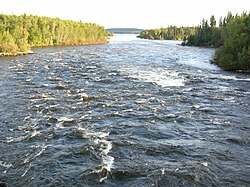
Navigating the rapids on the Sturgeon-Weir River Navigating the rapids on the Sturgeon-Weir River.jpeg
Navigating the rapids on the Sturgeon-Weir River
La Loche River La Loche River (Saskatchewan).JPG
La Loche River
The University Bridge over the South Saskatchewan River at Saskatoon South Saskatchewan River.jpg
The University Bridge over the South Saskatchewan River at Saskatoon
Otter rapids on the Churchill River Otter rapids.jpg
Otter rapids on the Churchill River
Beaver River north of Green Lake Beaver River, Canada.JPG
Beaver River north of Green Lake
Moose Mountain Creek, near Carlyle Moose Mountain Creek 03.jpg
Moose Mountain Creek, near Carlyle
RiverTotal drainage areaTotal length
North Saskatchewan [1] 122,800 km2 (47,400 sq mi)1,287 km (800 mi)
South Saskatchewan (to head of Bow River) [1] 335,900 km2 (129,700 sq mi)1,939 km (1,205 mi)
Saskatchewan River (to head of Bow River) [1] 146,100 km2 (56,400 sq mi)1,392 km (865 mi)
Churchill (to head of Churchill Lake) [1] 281,300 km2 (108,600 sq mi)1,609 km (1,000 mi)
Beaver (to outlet of Beaver Lake) [1] N/A491 km (305 mi)
Battle River (to head of Pigeon Lake) [1] 30,300 km2 (11,700 sq mi)570 km (350 mi)
Fond du Lac River (from outlet of Wollaston Lake) [1] 66,800 km2 (25,800 sq mi)277 km (172 mi)

Source Statistics Canada

Rivers by drainage basin

Alphabetical list of rivers

A

B

C

D

E

F

G

H

I

J

K

L

M

N

O

P

Q

R

S

T

U

V

W

Y

Z

See also

Related Research Articles

<span class="mw-page-title-main">Prince Albert National Park</span> National park in Saskatchewan, Canada

Prince Albert National Park encompasses 3,874 square kilometres (1,496 sq mi) in central Saskatchewan, Canada and is about 200 kilometres (120 mi) north of Saskatoon. Though declared a national park March 24, 1927, official opening ceremonies weren't performed by Prime Minister William Lyon Mackenzie King until August 10, 1928. This park is open all year but the most visited period is from May to September. Although named for the city of Prince Albert, the park's main entrance is actually 80 kilometres (50 mi) north of that city via Highways 2 and 263, which enters the park at its southeast corner. Two additional secondary highways enter the park, Highway 264, which branches off Highway 2 just east of the Waskesiu townsite, and Highway 240, which enters the park from the south and links with 263 just outside the entry fee-collection gates. Prince Albert National Park is not located within any rural municipality, and is politically separate from the adjacent Northern Saskatchewan Administration District (NSAD). Until the establishment of Grasslands National Park in 1981, it was the province's only national park.

<span class="mw-page-title-main">Churchill River (Hudson Bay)</span> River in Western Canada

The Churchill River is a major river in Alberta, Saskatchewan and Manitoba, Canada. From the head of the Churchill Lake it is 1,609 kilometres (1,000 mi) long. It was named after John Churchill, 1st Duke of Marlborough and governor of the Hudson's Bay Company from 1685 to 1691. The Cree name for the river is Missinipi, meaning "big waters". The Denesuline name for the river is des nëdhë́, meaning "Great River".

<span class="mw-page-title-main">Beaver River (Canada)</span> River in Western Canada

Beaver River is a large river in east-central Alberta and central Saskatchewan, Canada. It flows east through Alberta and Saskatchewan and then turns sharply north to flow into Lac Île-à-la-Crosse on the Churchill River which flows into Hudson Bay.

<span class="mw-page-title-main">Carrot River (Saskatchewan)</span> River in Western Canada

Carrot River is a river in Western Canada in the north-eastern part Saskatchewan and the north-western part of Manitoba. The outlet of Wakaw Lake in Saskatchewan marks the beginning of the Carrot River and, from there, it flows north-east past several communities and Indian reserves until it joins the Saskatchewan River in the Cumberland Delta in Manitoba. The river's mouth is west and upstream of the Pasquia River and The Pas on the Saskatchewan River.

<span class="mw-page-title-main">Wascana Creek</span> River in Saskatchewan, Canada

Wascana Creek is a river in the Canadian province of Saskatchewan. It is a tributary of the Qu'Appelle River.

<span class="mw-page-title-main">Waskesiu Lake</span> Lake in Prince Albert National Park, Saskatchewan, Canada

Waskesiu Lake is a lake located roughly in the centre of Prince Albert National Park. The lake's name means red deer or elk in the Cree language. Waskesiu Lake is by far the most developed lake in the park, and features a variety of recreational facilities along all sides of its shoreline, including camping, golfing, boating, and hiking. The resort village of Waskesiu Lake is on its eastern shore. The Prince Albert National Park Nature Centre is located in the village as well as many other amenities such as lodging, police, a gas station, shopping, and restaurants. Access to the lake is from Highways 263 and 264.

<span class="mw-page-title-main">Waterhen River (Saskatchewan)</span> River in Saskatchewan, Canada

Waterhen River is an east-flowing river in the north-west area of the Canadian province of Saskatchewan in the drainage basin of the Beaver River. It is north of and parallel to the east-flowing part of the Beaver River and joins the north-flowing part of that river. Most of the river and its drainage basin is at the southern edge of the boreal forest belt. While the river's source is Lac des Îles, its drainage basin reaches north into the Mostoos Hills and west well into the neighbouring province of Alberta.

<span class="mw-page-title-main">Moose Jaw River</span> River in Saskatchewan, Canada

Moose Jaw River is a river in the Canadian province of Saskatchewan. It is located in the southern part of the province in a region called the Prairie Pothole Region of North America, which extends throughout three Canadian provinces and five U.S. states. It is also within Palliser's Triangle and the Great Plains ecoregion.

Hudson Bay Regional Park is a regional park in the Canadian province of Saskatchewan. It is located on the south side of the town of Hudson Bay in the RM of Hudson Bay No. 394 along the shores of the Red Deer River. The park is the site of a North West Company fur trading fort called Fort Red Deer River that was built in 1790. About 14 kilometres (8.7 mi) downstream, near Erwood, was a Hudson's Bay Company trading post that was built in 1757.

<span class="mw-page-title-main">Red Deer River (Manitoba)</span> River in Western Canada

Red Deer River is a river in the Canadian provinces of Saskatchewan and Manitoba. It has its source at Nut Lake in east central Saskatchewan and from there, it flows east towards Manitoba where it empties into Dawson Bay of Lake Winnipegosis. To the north of Red Deer's basin is the Saskatchewan River, to the south-west is the upper Assiniboine River, and to the south-east is Swan River.

<span class="mw-page-title-main">Etomami River</span> River in Saskatchewan, Canada

Etomami River is a river in the Canadian province of Saskatchewan. The river originates in the Porcupine Hills and flows northward towards the town of Hudson Bay and into the Red Deer River. "Etomami" is a First Nations word that means "a place that three rivers join". It is in reference to the spot along the Red Deer River where the mouths of the Etomami and Fir Rivers meet the Red Deer River.

<span class="mw-page-title-main">Fir River</span> River in Saskatchewan, Canada

Fir River is a river in the Canadian province of Saskatchewan. The river's source is in the east central part of the province in the heart of the Pasquia Hills, which is one of four landforms that make up the Manitoba Escarpment. It flows in a southward direction until it meets up with the Red Deer River south of the town of Hudson Bay in Hudson Bay Regional Park. The river is in the boreal forest. Fir River is in the Nelson River drainage basin.

Lac des Îles is a lake in Meadow Lake Provincial Park in the Canadian Province of Saskatchewan in the boreal forest ecozone of Canada. The primary inflow is the Cold River and its outflow is the Waterhen River. The lake and associated rivers are part of the Hudson Bay drainage basin as the Waterhen River flows into Beaver River, which meets the Churchill River, a major river that flows into Hudson Bay, at Lac Île-à-la-Crosse.

The Cub Hills are a hilly plateau located south-east of the geographical centre of the Canadian province of Saskatchewan. The hills are in the boreal forest ecozone of Canada and the landforms of the hills were shaped more than 10,000 years ago during last ice age. Throughout the Cub Hills, there are dozens of lakes and rivers and several parks. The Cubs Hills are 150 km (93 mi) north-east of Prince Albert and are in the Northern Saskatchewan Administration District and Census Division #18. Several highways criss-cross the plateau to provide access to the various parks and other amenities.

<span class="mw-page-title-main">Pepaw River</span> River in Saskatchewan, Canada

Pepaw River, also spelt Peepaw, is a river in the east-central part of the Canadian province of Saskatchewan in the boreal forest ecozone of Canada. It begins in the Porcupine Hills and flows northward and meets up with the Etomami River south of the town of Hudson Bay. Much of the river is within Saskatchewan's Porcupine Provincial Forest and as such has various recreational opportunities along its course.

Waskesiu Upland is a hilly plateau in the central region of the Canadian province of Saskatchewan. Waskesiu means red deer or elk in the Cree language. The plateau is just south-west of the geographical centre of the province and consists of two main ranges — the Waskesiu Hills to the south and the Thunder Hills to the north. The Thunder Hills cover an area of about 225,000 acres. Several notable rivers begin from the upland with ones headed south flowing into the North Saskatchewan River and ones headed north flowing into the Churchill River. Much of the plateau is carpeted in boreal forests and most of the Waskesiu Hills range is within Prince Albert National Park. Besides the national park, there are several provincial recreation sites in and around the upland. The northern part of the upland is part of the Northern Saskatchewan Administration District and is sparsely populated.

References

  1. 1 2 3 4 5 6 7 Atlas of Canada. "Rivers in Canada". Archived from the original on 4 April 2007. Retrieved 1 May 2007.