Wascana Creek

Last updated

Wascana Creek
Wascana Creek 2017.jpg
Wascana Creek in Les Sherman Park, West End, downstream from the Albert Memorial Bridge and Wascana Lake
Quappellerivermap.png
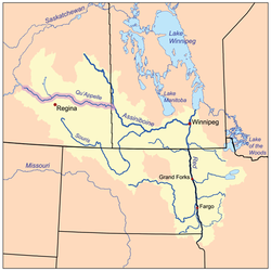
The Red River drainage basin, with the Qu'Appelle River highlighted
Canada Saskatchewan relief location map.jpg
Red pog.svg
Canada relief map 2.svg
Red pog.svg
Physical characteristics
Source 
  coordinates 50°39′00″N104°55′02″W / 50.65000°N 104.91722°W / 50.65000; -104.91722 [1]
Basin features
Bridges Albert Memorial Bridge and Sherwood Forest Bridge

Wascana Creek is a river [2] in the Canadian province of Saskatchewan. It is a tributary of the Qu'Appelle River.

Contents

Originating in the fields east of Regina near Vibank, Wascana Creek travels south-east for approximately 45 kilometres (28 mi) before turning back west at Tyvan. The creek then travels in a north-westwardly direction following Highway 33 through Regina, where it was dammed by the Canadian Pacific Railway to create Wascana Lake. The lake was created to supply water for steam locomotives and to create a decorative image in Regina. [3] Below the lake, the creek leaves Regina and ends at the Qu'Appelle River about 1 mile west of Lumsden.

Sherwood Forest Bridge and Albert Memorial Bridge are two of the bridges that cross Wascana Creek. Near the mouth of the river in the Wascana Valley, is a provincial recreation site called Wascana Trails that were developed for use in the 2005 Canada Summer Games.

A 2011 study by Environment Canada found the creek to have high levels of pollution. [4]

Wascana Creek Sub-basin

Wascana Creek Sub-basin is the name given to Wascana Creek's drainage basin. Along with the Moose Jaw River Watershed, [5] it is one of four sub-basins that make up the Wascana & Upper Qu’Appelle Watersheds; the other three being the Last Mountain Lake Sub-basin, Upper Qu’Appelle Sub-basin, and Lanigan-Manitou Sub-basin. The four sub-basins plus Moose Jaw River drain a total of 23,443 km2 of land. [6] The Craven Dam is located downstream from Wascana Creek's mouth on the Qu'Appelle River at the village of Craven.

Wascana Creek and its tributaries drain over 2,200 km2 of land. Several small tributaries feed the river, three of which are named:

Fish species

Brook stickleback and fathead minnow can be found in the Wascana Lake portion of the creek. [10]

See also

Related Research Articles

<span class="mw-page-title-main">Qu'Appelle River</span> River in Western Canada

The Qu'Appelle River is a river in the Canadian provinces of Saskatchewan and Manitoba that flows 430 kilometres (270 mi) east from Lake Diefenbaker in south-western Saskatchewan to join the Assiniboine River in Manitoba, just south of Lake of the Prairies, near the village of St. Lazare. It is in a region called the Prairie Pothole Region of North America, which extends throughout three Canadian provinces and five U.S. states. It is also within Palliser's Triangle and the Great Plains ecoregion.

<span class="mw-page-title-main">Fishing Lakes</span> Chain of lakes in Saskatchewan

The Fishing Lakes, also called the Calling Lakes or the Qu'Appelle Lakes, are a chain of four lakes in the Qu'Appelle Valley cottage country about 40 miles (64 km) to the north-east of Regina in the Canadian province of Saskatchewan. The lakes are in a region called the Prairie Pothole Region of North America, which extends throughout three Canadian provinces and five U.S. states. It is also within Palliser's Triangle and the Great Plains ecoregion. The Fishing Lakes all follow the course of the Qu'Appelle River, which flows from the west to the east and is part of the Hudson Bay drainage basin. The lakes sit in the deep-cut Qu'Appelle Valley that was formed about 14,000 years ago during the last ice age. Meltwater from the glaciers carved out the valley and as water levels rose and fell, alluvium was left in the wake. These piles of alluvium are what created the separations between the lakes.

<span class="mw-page-title-main">Pheasant Creek</span> River in Saskatchewan, Canada

Pheasant Creek is a creek that runs along the bottom of one of the many coulees that branch off the Qu'Appelle Valley and empties into the Qu'Appelle River in southern Saskatchewan. The creek starts between the communities of Ituna and Jasmin, meanders south of the village of Abernethy and north of the village of Sintaluta. The Qu'Appelle River drainage basin is divided into two sections, the Upper and lower watersheds. Pheasant Creek is a tributary of the lower watershed.

<span class="mw-page-title-main">Antler River</span> River in central North America

The Antler River is located in the Prairie Pothole Region of North America's Great Plains in south-eastern Saskatchewan and south-western Manitoba in Canada in an area known as Palliser's Triangle. Its source is in Saskatchewan's Moose Mountain Upland and it is a major tributary of the Souris River. As a result, its flood levels are monitored by the United States Geological Survey.

<span class="mw-page-title-main">Last Mountain Lake</span> Lake in Saskatchewan, Canada

Last Mountain Lake, also known as Long Lake, is a prairie lake formed from glaciation 11,000 years ago. It is located in south central Saskatchewan, Canada, about 40 kilometres (25 mi) north-west of the city of Regina. It flows into the Qu'Appelle River via Last Mountain Creek, which flows past Craven. It is approximately 93 km (58 mi) long, and 3 km (1.9 mi) wide at its widest point. It is the largest naturally occurring body of water in southern Saskatchewan. Only Lake Diefenbaker, which is man-made, is larger. The lake is a popular resort area for residents of south-eastern Saskatchewan.

<span class="mw-page-title-main">Waterhen River (Saskatchewan)</span> River in Saskatchewan, Canada

Waterhen River is an east-flowing river in the north-west area of the Canadian province of Saskatchewan in the drainage basin of the Beaver River. It is north of and parallel to the east-flowing part of the Beaver River and joins the north-flowing part of that river. Most of the river and its drainage basin is at the southern edge of the boreal forest belt. While the river's source is Lac des Îles, its drainage basin reaches north into the Mostoos Hills and west well into the neighbouring province of Alberta.

<span class="mw-page-title-main">Pipestone Creek (Saskatchewan)</span> River in central North America

Pipestone Creek is a river in the Souris River watershed. Its flow begins in southeastern Saskatchewan, just south of the town of Grenfell and travels in a southeastern direction into Manitoba in the Westman Region where it empties into Oak Lake through the Oak Lake Marsh.

<span class="mw-page-title-main">Moose Mountain Creek</span> River in southern Saskatchewan, Canada

Moose Mountain Creek is a river in the Canadian province of Saskatchewan. Its source is the Chapleau Lakes near Montmartre and it is a tributary of the Souris River, which, in turn, is a tributary of the Assiniboine River. The whole system is part of the Red River watershed, which is part of the Hudson Bay drainage basin and in a region called the Prairie Pothole Region of North America, which extends throughout three Canadian provinces and five U.S. states. It is also within Palliser's Triangle and the Great Plains ecoregion.

<span class="mw-page-title-main">Last Mountain Creek</span> River in Saskatchewan, Canada

Last Mountain Creek is a river in south-central Saskatchewan. It is a tributary of the Qu'Appelle River in a region called the Prairie Pothole Region of North America, which extends throughout three Canadian provinces and five U.S. states. It is also within Palliser's Triangle and the Great Plains ecoregion.

<span class="mw-page-title-main">Lanigan Creek</span> River in Saskatchewan, Canada

Lanigan Creek is a river in the Canadian province of Saskatchewan. It is located in the south central part of the province in a region called the Prairie Pothole Region of North America, which extends throughout three Canadian provinces and five U.S. states. It is also within Palliser's Triangle and the Great Plains ecoregion.

<span class="mw-page-title-main">Arm River (Saskatchewan)</span> River in Saskatchewan, Canada

Arm River is a river in the Canadian province of Saskatchewan. It is located in the south central part of the province in a region called the Prairie Pothole Region of North America, which extends throughout three Canadian provinces and five U.S. states. It is also within Palliser's Triangle and the Great Plains ecoregion.

<span class="mw-page-title-main">Moose Jaw River</span> River in Saskatchewan, Canada

Moose Jaw River is a river in the Canadian province of Saskatchewan. It is located in the southern part of the province in a region called the Prairie Pothole Region of North America, which extends throughout three Canadian provinces and five U.S. states. It is also within Palliser's Triangle and the Great Plains ecoregion.

<span class="mw-page-title-main">Plum Creek (Manitoba)</span> River in Manitoba

Plum Creek is the primary outflow for the Plum Lakes and travels in an easterly direction for about 28 kilometres until it meets up with the Souris River, which is part of the Hudson Bay drainage basin, at the community of Souris in the Canadian province of Manitoba. Plum Lakes and the beginning of Plum Creek are in the Rural Municipality of Sifton and the mouth is in the Municipality of Souris – Glenwood.

Eyebrow Lake is a man-made marshy lake that parallels the Qu'Appelle River in the southern region of the Canadian province of Saskatchewan. Located in the RM of Huron No. 223, it is the first lake in a series of lakes along the Qu'Appelle River after Qu'Appelle River Dam and Lake Diefenbaker. The next lake downstream is Buffalo Pound Lake. The closest community is the village of Tugaske and while there are no public recreation sites at the lake, it can be accessed by Highway 627. The lake gets its name from the nearby Eyebrow Hills, which are shaped like an eyebrow. The nearby town of Eyebrow and RM of Eyebrow No. 193 are also named after these hills.

Craven Dam is at the confluence of the Qu'Appelle River and Last Mountain Creek and immediately east of the village of Craven on the Qu'Appelle River at SW 24-20-21 W2. It is in the Canadian province of Saskatchewan in the RM of Longlaketon No. 219. The dam does not create a reservoir as its purpose is to regulate water flow along the Qu'Appelle River. The dam is operated by the Saskatchewan Water Security Agency and can be accessed on the north side by Highway 99.

First Mustus Lake is a lake in Meadow Lake Provincial Park in the Canadian Province of Saskatchewan in the boreal forest ecozone of Canada. The lake is the first of four lakes in a row named Mustus in the Rusty Creek watershed. The other lakes are Second, Third, and Fourth Mustus. Rusty Creek and the lakes are part of the Waterhen River drainage basin. The Waterhen River is a tributary of the Beaver River, which flows north into Lac Île-à-la-Crosse and the Churchill River, a major tributary in the Hudson Bay drainage basin. Highway 224 provides access to both First and Second Mustus Lakes.

Peitahigan Lake is a lake in Meadow Lake Provincial Park in the Canadian Province of Saskatchewan in the boreal forest ecozone of Canada. The lake is one of six notable lakes in the Rusty Creek watershed. The other lakes include Rusty, First Mustus, Second Mustus, Third Mustus, and Fourth Mustus. Rusty Creek and the lakes are part of the Waterhen River drainage basin. The Waterhen River is a tributary of the Beaver River, which flows north into Lac Île-à-la-Crosse and the Churchill River, a major tributary in the Hudson Bay drainage basin.

<span class="mw-page-title-main">Rusty Creek</span> River in Saskatchewan, Canada

Rusty Creek is a river in the Canadian province of Saskatchewan. The river's source is First Mustus Lake, which is a lake in Meadow Lake Provincial Park, and its mouth is along the course of the Waterhen River. It is a south flowing river and the entirety of its course is in Meadow Lake Provincial Park and the boreal forest ecozone. Rusty Creek is a tributary of Waterhen River, which is a major tributary of Beaver River of the Churchill River and in the Hudson Bay drainage basin.

Summit Lake is a lake in the east-central part of the Canadian province of Saskatchewan in Narrow Hills Provincial Park. It is situated in a glacier-formed valley in the Cub Hills and the boreal forest ecozone of Canada. It is located north of Lost Echo Lake and is accessed from Highway 913. There are no communities or settlements on the lake.

<span class="mw-page-title-main">Piwei River</span> River in Saskatchewan, Canada

Piwei River is a river in the east-central part of the Canadian province of Saskatchewan in the boreal forest ecozone of Canada. It begins at the western end of the Porcupine Hills at Piwei Lakes and heads in an easterly direction through a glacier-formed valley and into the Etomami River, which is a tributary of the Red Deer River.

References

  1. "Wascana Creek". Geographical Names Data Base . Natural Resources Canada . Retrieved 7 August 2021.
  2. Government of Canada, Natural Resources Canada. "Place names - Wascana Creek". www4.rncan.gc.ca.
  3. "Wascana Centre 2016 Master Plan" (PDF). Wascana Centre. p. 14. Retrieved 14 August 2018.
  4. "Regina's Wascana Creek has damaging pollutants". CBC News. 29 August 2011. Retrieved 14 August 2018.
  5. "Our Watershed".
  6. "Our Watershed". WUQWATR. Retrieved 17 September 2021.
  7. Government of Canada, Natural Resources Canada. "Place names - Manybone Creek". www4.rncan.gc.ca.
  8. Government of Canada, Natural Resources Canada. "Place names - Kronau Creek". www4.rncan.gc.ca.
  9. Government of Canada, Natural Resources Canada. "Place names - Cottonwood Creek". www4.rncan.gc.ca.
  10. "Habitat Conservation Area: A Self-guided Tour" (PDF). Wascana Centre. p. 3. Retrieved 14 August 2018.