Moose Jaw River

Last updated

Moose Jaw River
Moose Jaw River 01.jpg
Moose Jaw River
Quappellerivermap.png
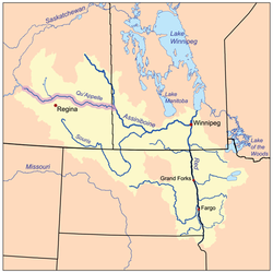
The Red River drainage basin, with the Qu'Appelle River highlighted
Canada Saskatchewan relief location map.jpg
Red pog.svg
Location of mouth in Saskatchewan
Canada relief map 2.svg
Red pog.svg
Moose Jaw River (Canada)
Location
CountryCanada
Provinces
Physical characteristics
SourceIbsen Lake
  coordinates 49°47′0″N104°15′22″W / 49.78333°N 104.25611°W / 49.78333; -104.25611
  elevation575 m (1,886 ft)
Mouth Qu'Appelle River
  location
Buffalo Pound Provincial Park
  coordinates
50°34′04″N105°17′42″W / 50.5679°N 105.2949°W / 50.5679; -105.2949
Basin size9,360 km2 (3,610 sq mi)
Basin features
River system Red River drainage basin
Tributaries 
  left

Moose Jaw River [1] is a river in the Canadian province of Saskatchewan. It is located in the southern part of the province in a region called the Prairie Pothole Region of North America, which extends throughout three Canadian provinces and five U.S. states. It is also within Palliser's Triangle and the Great Plains ecoregion. [2]

Contents

The Moose Jaw River drainage basin is one of five sub-basins that make up the Upper Qu'Appelle Watershed. [3] Craven Dam at the village of Craven is the dividing point between the upper and lower watersheds of the Qu'Appelle River. The river and its tributaries drain a total of 9,360 square kilometres (3,610 sq mi). [4] The total combined drainage area for the five sub-basins of the Upper Qu'Appelle Watershed is 23,443 square kilometres (9,051 sq mi). [5] The Qu'Appelle River system is part of the much larger Hudson Bay drainage basin.

Course

Pedestrian Bridge in Wakamow Park; it is part of the Trans Canada Trail. Moose Jaw River Pedestrian Bridge.jpg
Pedestrian Bridge in Wakamow Park; it is part of the Trans Canada Trail.

The source of the Moose Jaw River is Ibsen Lake, [6] which is about 6.4 kilometres (4.0 mi) west of Yellow Grass. From there, the river travels in a north-westerly direction following Highway 39 most of the way to the city of Moose Jaw. As the river reaches the city, it travels through the Wakamow Valley Park [7] before meeting Thunder Creek. The river snakes its way along the southern part of the city and at the south-east corner of Moose Jaw is the Kingsway Dam.

The Kingsway Dam ( 50°23′21″N105°30′07″W / 50.3893°N 105.5019°W / 50.3893; -105.5019 ), which is owned and operated by the Saskatchewan Water Security Agency, [8] is 5 metres (16 ft) high and was built in 1948. It helps control water flows along the Moose Jaw River and creates a 160-hectare (400-acre) reservoir in Wakamow Valley Park. [9] Upgrades were done to the dam in 1985 and, after unprecedented flooding in 2010 and 2011, significant repairs were completed. [10]

From the dam, the river heads east and then north where it meets the Qu'Appelle River about 3.2 kilometres (2.0 mi) east and downstream of Buffalo Pound Lake in the Nicolle Flats Marsh at the eastern end of Buffalo Pound Provincial Park. Several highways cross the river's path, including Highways 6, 334, 623, 339, 2, 1, and 301.

Tributaries

There are two main tributaries of the Moose Jaw River. Avonlea Creek [11] begins near the Piapot Cree First Nation 75G and flows in a north-west direction paralleling Moose Jaw River until near the village of Avonlea where it turns north and meets Moose Jaw River about 6.4 kilometres (4.0 mi) south-west of Rouleau. Along the course of Avonlea Creek is Watson Reservoir, [12] which is about 6.4 kilometres (4.0 mi) south-east of the town of Avonlea. At the north end of the reservoir is Dunnet Regional Park. [13]

The other main tributary is Thunder Creek. [14] Thunder Creek begins near Lake Diefenbaker and travels in a south-easterly direction and meets up with the Moose Jaw River in the city of Moose Jaw. There are four shallow, marshy lakes, Paysen (Horfield), Kettlehut, Williams, and Pelican along Thunder Creek's course and four main tributaries, Allin Creek, Aquadell Creek, Sandy Creek, and Wilson Creek. [15]

See also

Related Research Articles

<span class="mw-page-title-main">Saskatchewan River</span> River in western Canada

The Saskatchewan River is a major river in Canada. It stretches about 550 kilometres (340 mi) from where it is formed by the joining together of the North Saskatchewan River and South Saskatchewan River just east of Prince Albert, Saskatchewan, to Lake Winnipeg. It flows roughly eastward across Saskatchewan and Manitoba to empty into Lake Winnipeg. Through its tributaries the North Saskatchewan and South Saskatchewan, its watershed encompasses much of the prairie regions of Canada, stretching westward to the Rocky Mountains in Alberta and north-western Montana in the United States.

<span class="mw-page-title-main">South Saskatchewan River</span> River in Western Canada

The South Saskatchewan River is a major river in the Canadian provinces of Alberta and Saskatchewan. The river begins at the confluence of the Bow and Oldman Rivers in southern Alberta and ends at the Saskatchewan River Forks in central Saskatchewan. The Saskatchewan River Forks is the confluence of the South and North Saskatchewan Rivers and is the beginning of the Saskatchewan River.

<span class="mw-page-title-main">Battle Creek (Milk River tributary)</span> River in central North America

Battle Creek is a river that begins in the south-eastern region of the Canadian province of Alberta, near the border with Saskatchewan, in the Cypress Hills Interprovincial Park. From Alberta, Battle Creek flows east and across the border into Saskatchewan. It flows south out of Saskatchewan across the Canada–United States border into Montana, where it joins the Milk River in Blaine County, Montana.

<span class="mw-page-title-main">Qu'Appelle River Dam</span> Dam in Saskatchewan, Canada

The Qu'appelle River Dam is the smaller of two embankment dams: which created Lake Diefenbaker in Saskatchewan, Canada. The larger dam is Gardiner Dam, the biggest embankment dam in Canada and one of the biggest in the world. Construction of both dams began in the 1959 and was completed in 1967. The dam keeps the flow of water in the Qu'Appelle River relatively constant, as the Qu'Appelle River formerly dried up in many places every summer at the conclusion of the spring freshet from the Rocky Mountains, which feeds the South Saskatchewan River. This along with Buffalo Pound Dam at Buffalo Pound Lake, which supplies water to Regina, Moose Jaw and the Mosaic potash mine at Belle Plaine, keeps the lake from fluctuating excessively. The Canadian Pacific Railway crosses the river via the top of the dam, and the dam was designed with this type of loading in mind. The dam is 3100 metres long and 27 metres high. Douglas Provincial Park extends from the dam to Mistusinne.

<span class="mw-page-title-main">Qu'Appelle River</span> River in Western Canada

The Qu'Appelle River is a river in the Canadian provinces of Saskatchewan and Manitoba that flows 430 kilometres (270 mi) east from Lake Diefenbaker in south-western Saskatchewan to join the Assiniboine River in Manitoba, just south of Lake of the Prairies, near the village of St. Lazare. It is in a region called the Prairie Pothole Region of North America, which extends throughout three Canadian provinces and five U.S. states. It is also within Palliser's Triangle and the Great Plains ecoregion.

<span class="mw-page-title-main">Avonlea, Saskatchewan</span> Village in Saskatchewan, Canada

Avonlea is a village in the Canadian province of Saskatchewan within the RM of Elmsthorpe No. 100 and Census Division No. 2. The village is approximately 82 kilometres (51 mi) south-west of the city of Regina. The Southern Rails Cooperative maintains its head office in the village.

<span class="mw-page-title-main">Last Mountain Lake</span> Lake in Saskatchewan, Canada

Last Mountain Lake, also known as Long Lake, is a prairie lake formed from glaciation 11,000 years ago. It is located in south central Saskatchewan, Canada, about 40 kilometres (25 mi) north-west of the city of Regina. It flows into the Qu'Appelle River via Last Mountain Creek, which flows past Craven. It is approximately 93 km (58 mi) long, and 3 km (1.9 mi) wide at its widest point. It is the largest naturally occurring body of water in southern Saskatchewan. Only Lake Diefenbaker, which is man-made, is larger. The lake is a popular resort area for residents of south-eastern Saskatchewan.

<span class="mw-page-title-main">Wascana Creek</span> River in Saskatchewan, Canada

Wascana Creek is a river in the Canadian province of Saskatchewan. It is a tributary of the Qu'Appelle River.

<span class="mw-page-title-main">Buffalo Pound Lake</span> Lake in Sasketchewan, Canada

Buffalo Pound Lake is a eutrophic prairie lake in Saskatchewan, Canada, formed from glaciation about 10,000 years ago, on the Qu'Appelle River approximately 28 kilometres (17 mi) north of Moose Jaw and 11 kilometres (6.8 mi) north-east of Tuxford. The lake gets its name from the method used by First Nations people to capture the bison using the natural topography as corrals or buffalo pounds. Bison, once numbering more than 60 million on the prairies but almost extinct by 1900, were reintroduced into the area in 1972.

The Saskatchewan Water Security Agency is an arm's length organization responsible for the management of water resources to ensure safe drinking water sources and reliable water supplies for economic, environmental, and social benefits in Saskatchewan, Canada. The Agency is a Treasury Board Crown Corporation administered by a board of directors appointed by the provincial government. Water Security Agency is located in Moose Jaw, SK, Canada and is part of the Water, Sewage and Other Systems Industry. Water Security Agency has 320.5 full time equivalent employees across all of its locations.

<span class="mw-page-title-main">Pipestone Creek (Saskatchewan)</span> River in central North America

Pipestone Creek is a river in the Souris River watershed. Its flow begins in southeastern Saskatchewan, just south of the town of Grenfell and travels in a southeastern direction into Manitoba in the Westman Region where it empties into Oak Lake through the Oak Lake Marsh.

<span class="mw-page-title-main">Moose Mountain Creek</span> River in southern Saskatchewan, Canada

Moose Mountain Creek is a river in the Canadian province of Saskatchewan. Its source is the Chapleau Lakes near Montmartre and it is a tributary of the Souris River, which, in turn, is a tributary of the Assiniboine River. The whole system is part of the Red River watershed, which is part of the Hudson Bay drainage basin and in a region called the Prairie Pothole Region of North America, which extends throughout three Canadian provinces and five U.S. states. It is also within Palliser's Triangle and the Great Plains ecoregion.

<span class="mw-page-title-main">Last Mountain Creek</span> River in Saskatchewan, Canada

Last Mountain Creek is a river in south-central Saskatchewan. It is a tributary of the Qu'Appelle River in a region called the Prairie Pothole Region of North America, which extends throughout three Canadian provinces and five U.S. states. It is also within Palliser's Triangle and the Great Plains ecoregion.

<span class="mw-page-title-main">Lanigan Creek</span> River in Saskatchewan, Canada

Lanigan Creek is a river in the Canadian province of Saskatchewan. It is located in the south central part of the province in a region called the Prairie Pothole Region of North America, which extends throughout three Canadian provinces and five U.S. states. It is also within Palliser's Triangle and the Great Plains ecoregion.

<span class="mw-page-title-main">Arm River (Saskatchewan)</span> River in Saskatchewan, Canada

Arm River is a river in the Canadian province of Saskatchewan. It is located in the south central part of the province in a region called the Prairie Pothole Region of North America, which extends throughout three Canadian provinces and five U.S. states. It is also within Palliser's Triangle and the Great Plains ecoregion.

<span class="mw-page-title-main">Brightwater Creek</span> River in Saskatchewan, Canada

Brightwater Creek is a river in south central part of the Canadian province of Saskatchewan. It is a tributary of the South Saskatchewan River in a region called the Prairie Pothole Region of North America, which extends throughout three Canadian provinces and five U.S. states. It is also within Palliser's Triangle and the Great Plains ecoregion. Along the river's course there is a dam and reservoir and a regional park. There are no communities along its course.

<span class="mw-page-title-main">Avonlea Creek</span> River in Saskatchewan, Canada

Avonlea Creek is a river in the southern part of the Canadian province of Saskatchewan. It is in a region called the Prairie Pothole Region of North America, which extends throughout three Canadian provinces and five U.S. states. It is also within Palliser's Triangle and the Great Plains ecoregion. Avonlea Creek is a main tributary of the Moose Jaw River, which is part of the Upper Qu'Appelle Watershed and the Hudson Bay drainage basin.

<span class="mw-page-title-main">Thunder Creek (Saskatchewan)</span> River in Saskatchewan, Canada

Thunder Creek is a river in the Canadian province of Saskatchewan. The watershed of Thunder Creek is within the semi-arid Palliser's Triangle in south-central Saskatchewan. It begins at small, man-made reservoir near Lake Diefenbaker and flows in a south-easterly direction towards the city of Moose Jaw and the Moose Jaw River. The Moose Jaw River is a major tributary of the Qu'Appelle River For most of its course, Thunder Creek follows a valley called the Thunder Creek meltwater channel that was formed over 10,000 years ago near the end of the last ice age.

Craven Dam is at the confluence of the Qu'Appelle River and Last Mountain Creek and immediately east of the village of Craven on the Qu'Appelle River at LSD SW 24-20-21 W2. It is in the Canadian province of Saskatchewan in the RM of Longlaketon No. 219. The dam does not create a reservoir as its purpose is to regulate water flow along the Qu'Appelle River. The dam is operated by the Saskatchewan Water Security Agency and can be accessed on the north side by Highway 99.

References

  1. "Moose Jaw River". Canadian Geographical Names Database. Government of Canada. Retrieved 30 November 2022.
  2. Bonikowsky, Laura (14 July 2013). "Drought in Palliser's Triangle". The Canadian Encyclopedia. Retrieved 12 March 2024.
  3. "Our Watershed". WUQWATR. Retrieved 19 September 2021.
  4. Caring for Our Watersheds. (n.d.). Watershed information. Retrieved from https://caringforourwatersheds.com/canada/saskatchewan/watershed-information/
  5. "Our Watershed". WUQWATR. Retrieved 17 September 2021.
  6. "Isben Lake". Canadian Geographical Names Database. Government of Canada. Retrieved 20 December 2022.
  7. "Wakamow Valley". Tourism Saskatchewan. Government of Saskatchewan. Retrieved 31 October 2023.
  8. "Dams and Reservoirs". wsask. Water Security Agency. Retrieved 12 March 2024.
  9. "A Park for All Seasons". Wakamow Valley. Wakamow Valley Authority. Retrieved 13 March 2024.
  10. "Kingsway Dam Rehabilitation Complete". Saskatchewan. Government of Saskatchewan. 12 December 2012. Retrieved 12 March 2024.
  11. "Avonlea Creek". Canadian Geographical Names Database. Government of Canada. Retrieved 20 December 2022.
  12. "Avonlea Reservoir". Angler's Atlas. Retrieved 12 March 2024.
  13. "Dunnet". Regional Parks of Saskatchewan. Saskatchewan Regional Parks. Retrieved 12 March 2024.
  14. "Thunder Creek". Canadian Geographical Names Database. Government of Canada. Retrieved 20 December 2022.
  15. "Our Watershed". Moose Jaw River. Moose Jaw River Watershed Stewards. Retrieved 29 December 2022.