Avonlea Creek

Last updated

Avonlea Creek
Quappellerivermap.png
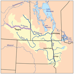
The Red River drainage basin, with the Qu'Appelle River highlighted
Canada Saskatchewan relief location map.jpg
Red pog.svg
Location in Saskatchewan
Canada relief map 2.svg
Red pog.svg
Avonlea Creek (Canada)
Location
CountryCanada
Provinces Saskatchewan
Physical characteristics
Source Piapot Cree First Nation 75G
  coordinates 49°45′47″N104°40′15″W / 49.76306°N 104.67083°W / 49.76306; -104.67083
  elevation640 m (2,100 ft)
Mouth Moose Jaw River
  location
4 miles south-west of Rouleau
  coordinates
50°9′0″N104°57′2″W / 50.15000°N 104.95056°W / 50.15000; -104.95056
Basin features
River system Red River

Avonlea Creek [1] is a river in the southern part of the Canadian province of Saskatchewan. It is in a region called the Prairie Pothole Region of North America, which extends throughout three Canadian provinces and five U.S. states. It is also within Palliser's Triangle and the Great Plains ecoregion. [2] Avonlea Creek is a main tributary of the Moose Jaw River, which is part of the Upper Qu'Appelle Watershed [3] and the Hudson Bay drainage basin.

Contents

Course

Avonlea Creek begins at Piapot Cree First Nation 75G, about 5 kilometres (3.1 mi) south-east of the intersection of Highway 6 and Highway 712. From there, it travels in a north-westerly direction past Parry, paralleling the Moose Jaw River until it empties into the Watson Reservoir, south-east of the village of Avonlea. From the reservoir, the river heads north until it meets the Moose Jaw River near Rouleau.

The headwaters of the river are in the Missouri Coteau [4] and The Dirt Hills to the west are the source of several tributaries.

Watson Reservoir

Reg Watson Reservoir, also known as Avonlea Reservoir ( 49°58′40″N104°59′47″W / 49.9778°N 104.9964°W / 49.9778; -104.9964 ), [5] was created with the building of Avonlea Dam between 1963 and 1964 [6] across Avonlea Creek. The dam was originally built by the Prairie Farm Rehabilitation Administration and is now operated by the Saskatchewan Water Security Agency. The dam is 16.6 metres (54 ft) high and the reservoir holds 7,400 dam3 (6,000 acre⋅ft) of water and has a surface area of 201.5 hectares (498 acres). It is about 5 kilometres (3.1 mi) south-east of Avonlea and is the source of water for the village. The dam was upgraded in 2003.

The reservoir is stocked every second year with fish. Northern pike, walleye, burbot, and yellow perch are found in the lake and there are several boat launches around the lake for access. [7]

Dunnet Regional Park

Dunnet Regional Park ( 49°59′35″N105°00′41″W / 49.9931°N 105.0115°W / 49.9931; -105.0115 ), built in 1967, is a regional park located on the west side of Reg Watson Reservoir. It was named after a local medical doctor. The park consists of 50 acres in a naturally treed valley and features RV parking, camping, fishing, boating, mini golf, a heated swimming pool, and eight baseball diamonds. [8] [9]

To the north of the park, along the west bank of Avonlea Creek, is an 18-hole championship golf course called Long Creek Golf & Country Club. [10]

See also

Related Research Articles

<span class="mw-page-title-main">Battle Creek (Milk River tributary)</span> River in central North America

Battle Creek is a river that begins in the south-eastern region of the Canadian province of Alberta, near the border with Saskatchewan, in the Cypress Hills Interprovincial Park. From Alberta, Battle Creek flows east and across the border into Saskatchewan. It flows south out of Saskatchewan across the Canada–United States border into Montana, where it joins the Milk River in Blaine County, Montana.

<span class="mw-page-title-main">Qu'Appelle River</span> River in Western Canada

The Qu'Appelle River is a river in the Canadian provinces of Saskatchewan and Manitoba that flows 430 kilometres (270 mi) east from Lake Diefenbaker in south-western Saskatchewan to join the Assiniboine River in Manitoba, just south of Lake of the Prairies, near the village of St. Lazare. It is in a region called the Prairie Pothole Region of North America, which extends throughout three Canadian provinces and five U.S. states. It is also within Palliser's Triangle and the Great Plains ecoregion.

<span class="mw-page-title-main">Assiniboia, Saskatchewan</span> Town in Saskatchewan

Assiniboia is a town in the Canadian province of Saskatchewan. It is located 110 km (68 mi) south-southwest of Moose Jaw beside Highway 2 and Highway 13.

<span class="mw-page-title-main">Radville</span> Town in Saskatchewan, Canada

Radville is a small town in Canadian province of Saskatchewan, in the RM of Laurier No. 38. It was incorporated in 1911 after being settled in 1895. Highway 28 and Highway 377 pass through the town. Nearby communities include the village of Ceylon, 23 km to the west, and the city of Weyburn, 51 km to the north-east. Major nearby urban centres include Regina, which is 148 km to the north, and Moose Jaw, which is 143 km north-west.

<span class="mw-page-title-main">Avonlea, Saskatchewan</span> Village in Saskatchewan, Canada

Avonlea is a village in the Canadian province of Saskatchewan within the RM of Elmsthorpe No. 100 and Census Division No. 2. The village is approximately 82 kilometres (51 mi) south-west of the city of Regina. The Southern Rails Cooperative maintains its head office in the village.

<span class="mw-page-title-main">Grant Devine Dam</span> Dam and reservoir in Saskatchewan, Canada

The Grant Devine Dam, formerly Alameda Dam, is an embankment dam located in the Canadian province near Alameda and Oxbow. It was constructed in 1994 to control flows on Moose Mountain Creek and Souris River. It provides flood protection and irrigation for this area of Saskatchewan, along with protection for Minot, North Dakota. The Grant Devine Reservoir provides opportunities for recreational use such as boating and fishing. At the full supply level of 562 metres (1,844 ft), the reservoir holds 105,000,000 m3 (3.7×10⁹ cu ft) of water. The project is owned and operated by the Saskatchewan Water Security Agency (formerly Saskatchewan Watershed Authority).

<span class="mw-page-title-main">Last Mountain Lake</span> Lake in Saskatchewan, Canada

Last Mountain Lake, also known as Long Lake, is a prairie lake formed from glaciation 11,000 years ago. It is located in south central Saskatchewan, Canada, about 40 kilometres (25 mi) north-west of the city of Regina. It flows into the Qu'Appelle River via Last Mountain Creek, which flows past Craven. It is approximately 93 km (58 mi) long, and 3 km (1.9 mi) wide at its widest point. It is the largest naturally occurring body of water in southern Saskatchewan. Only Lake Diefenbaker, which is man-made, is larger. The lake is a popular resort area for residents of south-eastern Saskatchewan.

Lac Pelletier is a natural, spring fed lake in the south-west region of the Canadian province of Saskatchewan. It is located in the RM of Lac Pelletier No. 107 in the semi arid Palliser's Triangle. The lake is named after Norbert Pelletier, who was a Métis man that held the first land grant in the area. The lake has one community, a regional park, and two Bible camps along its shores. Access to the lake and its amenities is from Highway 343.

The Saskatchewan Water Security Agency is an arm's length organization responsible for the management of water resources to ensure safe drinking water sources and reliable water supplies for economic, environmental, and social benefits in Saskatchewan, Canada. The Agency is a Treasury Board Crown Corporation administered by a board of directors appointed by the provincial government. Water Security Agency is located in Moose Jaw, SK, Canada and is part of the Water, Sewage and Other Systems Industry. Water Security Agency has 320.5 full time equivalent employees across all of its locations.

<span class="mw-page-title-main">McDonald Lake (Saskatchewan)</span> Lake in Saskatchewan, Canada

McDonald Lake, also known as Rafferty Reservoir, is a reservoir in south-east part of the Canadian province of Saskatchewan. It was created when the Rafferty Dam was built on the Souris River in 1994. Before the dam was built that flooded the Souris Valley, McDonald Lake was a small lake and marsh on the valley floor adjacent to the Souris River.

<span class="mw-page-title-main">Pipestone Creek (Saskatchewan)</span> River in central North America

Pipestone Creek is a river in the Souris River watershed. Its flow begins in southeastern Saskatchewan, just south of the town of Grenfell and travels in a southeastern direction into Manitoba in the Westman Region where it empties into Oak Lake through the Oak Lake Marsh.

<span class="mw-page-title-main">Long Creek (Saskatchewan)</span> River in central North America

Long Creek is a river in central North America that begins in Saskatchewan, flows south-east into North Dakota, and then flows back north into Saskatchewan. It is a tributary of the Souris River. The Souris River drains into the Assiniboine River, which is part of the Red River drainage basin in a region called the Prairie Pothole Region of North America, which extends throughout three Canadian provinces and five U.S. states. It is also within Palliser's Triangle and the Great Plains ecoregion. In 1957, a dam was built on Long Creek near where it meets the Souris River to create Boundary Dam Reservoir.

<span class="mw-page-title-main">Moose Mountain Creek</span> River in southern Saskatchewan, Canada

Moose Mountain Creek is a river in the Canadian province of Saskatchewan. Its source is the Chapleau Lakes near Montmartre and it is a tributary of the Souris River, which, in turn, is a tributary of the Assiniboine River. The whole system is part of the Red River watershed, which is part of the Hudson Bay drainage basin and in a region called the Prairie Pothole Region of North America, which extends throughout three Canadian provinces and five U.S. states. It is also within Palliser's Triangle and the Great Plains ecoregion.

<span class="mw-page-title-main">Moose Mountain Lake</span> Lake in Saskatchewan, Canada

Moose Mountain Lake is a reservoir in the Canadian province of Saskatchewan. It is located in the RM of Golden West No. 95 in the Prairies Ecozone of Palliser's Triangle at the western edge of Moose Mountain Upland. Moose Mountain Creek is both the primary inflow and outflow of the lake; it enters at the north end and leaves at the dam in the south end. A secondary inflow that comes from Gooseberry Lake enters on the western side near the south end.

<span class="mw-page-title-main">Lanigan Creek</span> River in Saskatchewan, Canada

Lanigan Creek is a river in the Canadian province of Saskatchewan. It is located in the south central part of the province in a region called the Prairie Pothole Region of North America, which extends throughout three Canadian provinces and five U.S. states. It is also within Palliser's Triangle and the Great Plains ecoregion.

<span class="mw-page-title-main">Arm River (Saskatchewan)</span> River in Saskatchewan, Canada

Arm River is a river in the Canadian province of Saskatchewan. It is located in the south central part of the province in a region called the Prairie Pothole Region of North America, which extends throughout three Canadian provinces and five U.S. states. It is also within Palliser's Triangle and the Great Plains ecoregion.

<span class="mw-page-title-main">Moose Jaw River</span> River in Saskatchewan, Canada

Moose Jaw River is a river in the Canadian province of Saskatchewan. It is located in the southern part of the province in a region called the Prairie Pothole Region of North America, which extends throughout three Canadian provinces and five U.S. states. It is also within Palliser's Triangle and the Great Plains ecoregion.

<span class="mw-page-title-main">Thunder Creek (Saskatchewan)</span> River in Saskatchewan, Canada

Thunder Creek is a river in the Canadian province of Saskatchewan. The watershed of Thunder Creek is within the semi-arid Palliser's Triangle in south-central Saskatchewan. It begins at small, man-made reservoir near Lake Diefenbaker and flows in a south-easterly direction towards the city of Moose Jaw and the Moose Jaw River. The Moose Jaw River is a major tributary of the Qu'Appelle River For most of its course, Thunder Creek follows a valley called the Thunder Creek meltwater channel that was formed over 10,000 years ago near the end of the last ice age.

Wood River is a river in the Canadian province of Saskatchewan. It has its source in the Wood Mountain Hills of south-western Saskatchewan and flows in a north-easterly direction to its mouth at Old Wives Lake. Old Wives Lake is a salt water lake with no outflow. As a result, the drainage basin of Wood River is an endorheic one. Along the course of the river, there are several parks, historical sites, and small towns.

Thomson Lake is a reservoir in the Canadian province of Saskatchewan along the course of Wood River in the Old Wives Lake closed watershed. The lake was created in 1958 for irrigation and consumption with the damming of Wood River. It was named after Dr Leonard Thomson who was the director of the Prairie Farm Rehabilitation Administration (PFRA) at the time.

References

  1. "Avonlea Creek". Canadian Geographical Names Database. Government of Canada. Retrieved 7 May 2022.
  2. Bonikowsky, Laura (14 July 2013). "Drought in Palliser's Triangle". The Canadian Encyclopedia. Retrieved 13 March 2024.
  3. "Our Watershed". WUQWATR. Retrieved 19 September 2021.
  4. "Our Watershed". Moose Jaw River. Moose Jaw River Watershed Stewards. Retrieved 29 December 2022.
  5. "Watson Reservoir". Canadian Geographical Names Database. Government of Canada. Retrieved 20 December 2022.
  6. "Dams and Reservoirs". wsask. Water Security Agency. Retrieved 12 March 2024.
  7. "Avonlea Reservoir". Angler's Atlas. Retrieved 12 March 2024.
  8. "Dunnet Regional Park | Tourism Saskatchewan".
  9. "Dunnet". Regional Parks of Saskatchewan. Saskatchewan Regional Parks. Retrieved 12 March 2024.
  10. "Long Creek Golf & Country Club - Golf Canada".