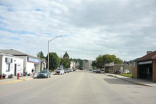
Lumsden is a town in the Qu'Appelle Valley in south central Saskatchewan, Canada, 31 km northwest of the city of Regina. It is surrounded by the Rural Municipality of Lumsden No. 189. The town functions as both a farming community and an unofficial suburb of Regina. Lumsden has an active artistic community, which consists of many writers, painters, and sculptors.
Buena Vista is a village in the Canadian province of Saskatchewan within the Rural Municipality of Lumsden No. 189 and Census Division No. 6. The village is located 40 km (25 mi) north-west of Regina, on the southern shore of Last Mountain Lake just off Highway 54. It is bounded to the west by Regina Beach, demarcated by 16 Street.

Abernethy is a village in the Canadian province of Saskatchewan within the Rural Municipality of Abernethy No. 186 and Census Division No. 6. It is about one hour east of Regina, one hour west of Yorkton, and approximately five hours northwest of Winnipeg. To the south of Abernethy lies the Qu'Appelle Valley in which Katepwa Beach is located.

The Rural Municipality of Lumsden No. 189 is a rural municipality (RM) in the Canadian province of Saskatchewan within Census Division No. 6 and SARM Division No. 2. It is located in the south-east portion of the province.

Regina Beach is a town in south central Saskatchewan, located on Highway 54, close to where Highway 11 intersects with the Qu'Appelle Valley.

Division No. 6 is one of eighteen census divisions in the province of Saskatchewan, Canada, as defined by Statistics Canada. It is located in the south-central part of the province. The most populous community in this division is Regina, the provincial capital.
Wilcox is a village in the Canadian province of Saskatchewan within the Rural Municipality of Bratt's Lake No. 129 and Census Division No. 6. It is approximately 41 kilometres (25 mi) south of the city of Regina.

Lebret is a village in the Canadian province of Saskatchewan within the Rural Municipality of North Qu'Appelle No. 187 and Census Division No. 6. The village is situated on Mission Lake of the Fishing Lakes in the Qu'Appelle Valley. Lebret is located along Highway 56, about 70 km (43 mi) northeast of the City of Regina. The village was named after "the parish priest, Father Louis Lebret, who became the first postmaster of the community and, although he only held the position for a little more than six months, the office was named Lebret and the name became that of the community."

The Rural Municipality of North Qu'Appelle No. 187 is a rural municipality (RM) in the Canadian province of Saskatchewan within Census Division No. 6 and SARM Division No. 1. It is located in the south-east portion of the province.

Belle Plaine is a village in the Canadian province of Saskatchewan within the Rural Municipality of Pense No. 160 and Census Division No. 6. Belle Plaine is located on Highway 1, 21 kilometres east of the City of Moose Jaw in south-central Saskatchewan. Buffalo Pound Provincial Park and Regina Beach are located near Belle Plaine.

Bethune is a village in the Canadian province of Saskatchewan within the Rural Municipality of Dufferin No. 190 and Census Division No. 6. The village is 56 kilometres (35 mi) north-west of Regina on Highway 11. Arm River flows along a river valley north of Bethune, which features camping sites, and the Qu'Appelle River is a short way south. Last Mountain Lake or Long Lake is north-east of Bethune whereas Buffalo Pound Lake is just south-west.

Eyebrow is a village in the Canadian province of Saskatchewan within the Rural Municipality of Eyebrow No. 193 and Census Division No. 7. The community originated at the location that is now the abandoned community of Eskbank several kilometres to the south. Eyebrow is located at the intersection of Highway 367 and Highway 42; 84 km northwest of Moose Jaw, 154 km northwest of Regina and 196 km south of Saskatoon.

The Rural Municipality of South Qu'Appelle No. 157 is a rural municipality (RM) in the Canadian province of Saskatchewan within Census Division No. 6 and SARM Division No. 1. It is located in the southeast portion of the province.

Disley is a village in the Canadian province of Saskatchewan within the Rural Municipality of Lumsden No. 189 and Census Division No. 6. It is located 18 km (11 mi) west of Lumsden just south of the Louis Riel Trail and 48 km (30 mi) northwest of the City of Regina.
McLean is a village in the Canadian province of Saskatchewan within the Rural Municipality of South Qu'Appelle No. 157 and Census Division No. 6. It is on Highway 1 between Qu'Appelle and Balgonie. The village of McLean is located in South Central Saskatchewan on the Trans-Canada Highway and is the highest point on the Canadian Pacific Railway mainline east of the Rockies. It is about 37 kilometres (23 mi) east of the Regina. The population of McLean is 405.
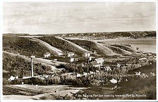
Fort San is a resort village in the Canadian province of Saskatchewan within Census Division No. 6. It is on the shores of Echo Lake of the Fishing Lakes in the Rural Municipality of North Qu'Appelle No. 187. It is 3 kilometres (1.9 mi) west of Fort Qu'Appelle and approximately 77 kilometres (48 mi) northeast of Regina.
Tantallon is a village in the Canadian province of Saskatchewan within the Rural Municipality of Spy Hill No. 152 and Census Division No. 5. It is in the Qu'Appelle Valley along the Qu'Appelle River about 39 km east of Round Lake (Saskatchewan). The community celebrated its centennial in 2004.
Tugaske is a village in the Canadian province of Saskatchewan within the Rural Municipality of Huron No. 223 and Census Division No. 7. It is nicknamed Gateway to Lake Diefenbaker. It is near Eyebrow Lake, a prairie lake in the Qu'Appelle Valley. It was named after an eyebrow-shaped hill also in the Qu'Appelle Valley above Eyebrow Lake. The lake, which is 9 km long and 1 km wide, is a bird sanctuary and is near Highway 627.
B-Say-Tah is a resort village in the Canadian province of Saskatchewan within Census Division No. 6. It is on the shores of Echo Lake of the Fishing Lakes in the Rural Municipality of North Qu'Appelle No. 187. It is approximately 70 kilometres (43 mi) north-east of Regina and 5 kilometres (3.1 mi) west of Fort Qu'Appelle on Highway 210. Echo Valley Provincial Park is 2 kilometres (1.2 mi) to the west.
Lumsden Beach is a resort village in the Canadian province of Saskatchewan, Canada, within Census Division No. 6. It is on the shores of Last Mountain Lake in the Rural Municipality of Lumsden No. 189.


