Division No. 6, Saskatchewan

Last updated

Division No. 6
Country Flag of Canada (Pantone).svg  Canada
Province Flag of Saskatchewan.svg  Saskatchewan
Area
  Total17,548.18 km2 (6,775.39 sq mi)
 As of 2016
Population
 (2016)
  Total262,837
  Density15/km2 (39/sq mi)

Division No. 6 is one of eighteen census divisions in the province of Saskatchewan, Canada, as defined by Statistics Canada. It is located in the south-central part of the province. The most populous community in this division is Regina, the provincial capital.

Contents

Demographics

In the 2021 Census of Population conducted by Statistics Canada, Division No. 6 had a population of 276,564 living in 111,468 of its 122,908 total private dwellings, a change of

Knowledge of languages in Division No. 6 (1991−2021)
Language2021 [2] 2011 [3] [4] 2001 [5] [6] 1991 [7]
Pop. %Pop.%Pop.%Pop.%
English 268,710233,365215,485215,085
French 15,12012,42512,03511,540
Hindustani [lower-alpha 1] 11,7302,900645515
Tagalog 10,0503,865750460
Punjabi 6,0851,575500275
Chinese [lower-alpha 2] 5,4703,3852,3252,475
Spanish 2,8952,5001,8551,390
Arabic 2,690845505200
German [lower-alpha 3] 2,1253,9956,60010,080
Vietnamese 2,0651,015955855
Ukrainian 1,8451,8452,8354,185
Russian 1,7001,140410405
Cree [lower-alpha 4] 1,0206701,195975
Greek 810675705435
Italian 615620785795
Polish 4306201,0301,280
Persian [lower-alpha 5] 420220180230
Portuguese 35013570115
Hungarian 3255509751,340
Dutch 325315485680
Total responses271,810234,990216,160216,165
Total population276,564237,746219,250218,612

Census subdivisions

The following census subdivisions (municipalities or municipal equivalents) are located within Saskatchewan's Division No. 6.

City

Towns

Villages

Resort villages

Rural municipalities

  • RM No. 126 Montmartre
  • RM No. 127 Francis
  • RM No. 128 Lajord
  • RM No. 129 Bratt's Lake
  • RM No. 130 Redburn
  • RM No. 156 Indian Head
  • RM No. 157 South Qu'Appelle
  • RM No. 158 Edenwold
  • RM No. 159 Sherwood
  • RM No. 160 Pense
  • RM No. 186 Abernethy
  • RM No. 187 North Qu'Appelle
  • RM No. 189 Lumsden
  • RM No. 190 Dufferin
  • RM No. 216 Tullymet
  • RM No. 217 Lipton
  • RM No. 218 Cupar
  • RM No. 219 Longlaketon
  • RM No. 220 McKillop
  • RM No. 221 Sarnia

[8]

Indian reserves

See also

Notes

  1. Combined responses of Hindi and Urdu as they form mutually intelligible registers of the Hindustani language.
  2. Combined responses of the Chinese languages, including Mandarin, Cantonese, Min Nan, Hakka, Wu (Shanghainese), Min Dong, Chinese, n.o.s., and Chinese languages, n.i.e..
  3. Combined responses of the High German languages, including Standard German, Pennsylvania German, Swiss German, and Yiddish.
  4. Combined responses of the Cree-Innu languages, previously categorized under "Cree" in past censuses.
  5. Combined responses of Iranian Persian, Dari, and Persian (Farsi), n.o.s., as they form mutually intelligible registers of the Persian language

Related Research Articles

<span class="mw-page-title-main">Regina—Qu'Appelle</span> Federal electoral district in Saskatchewan, Canada

Regina–Qu'Appelle is a federal electoral district in Saskatchewan, Canada, that has been represented in the House of Commons of Canada from 1904 to 1968 and since 1988.

<span class="mw-page-title-main">Edmonton Metropolitan Region</span> Metropolitan area in Canada, Alberta

The Edmonton Metropolitan Region (EMR), also commonly referred to as Greater Edmonton or Metro Edmonton, is a conglomeration of municipalities centred on Edmonton, the capital of the Canadian province of Alberta.

<span class="mw-page-title-main">Rural Municipality of Taché</span> Rural municipality in Manitoba, Canada

Taché is a rural municipality in Manitoba, Canada, incorporated in 1880.

<span class="mw-page-title-main">Division No. 2, Saskatchewan</span> Census division of Saskatchewan, Canada

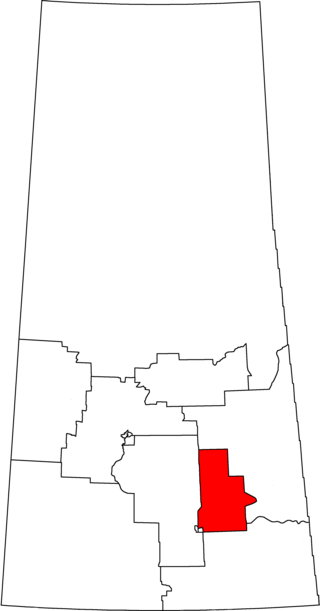
Division No. 2 is one of eighteen census divisions in the province of Saskatchewan, Canada, as defined by Statistics Canada. It is located in the south-southeastern part of the province, on the United States border. The most populous community in this division is Weyburn.

<span class="mw-page-title-main">Division No. 1, Saskatchewan</span> Census division of Saskatchewan, Canada

Division No. 1 is one of eighteen census divisions in the province of Saskatchewan, Canada, as defined by Statistics Canada. It is located in the southeast corner of the province, bordering Manitoba and North Dakota. The most populous community in this division is Estevan.

<span class="mw-page-title-main">Division No. 3, Saskatchewan</span> Census division of Saskatchewan, Canada

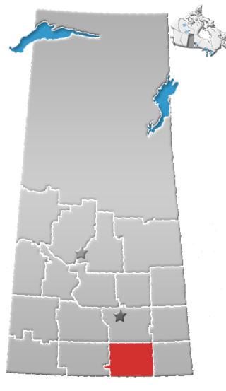
Division No. 3 is one of eighteen census divisions in the province of Saskatchewan, Canada, as defined by Statistics Canada. It is located in the south-southwestern part of the province, adjacent to the border with Montana, United States. The most populous community in this division is Assiniboia.

<span class="mw-page-title-main">Division No. 4, Saskatchewan</span> Census division of Saskatchewan, Canada

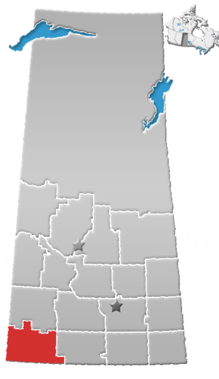
Division No. 4 is one of eighteen census divisions in the province of Saskatchewan, Canada, as defined by Statistics Canada. It is located in the southwest corner of the province, bordering Alberta to the west and Montana, United States to the south. The most populous community in this division is Maple Creek.

<span class="mw-page-title-main">Division No. 5, Saskatchewan</span> Census division of Saskatchewan, Canada

Division No. 5 is one of eighteen census divisions in the province of Saskatchewan, Canada, as defined by Statistics Canada. It is located in the east-southeastern part of the province, bordering Manitoba. The most populous community in this division is Melville.

<span class="mw-page-title-main">Division No. 7, Saskatchewan</span> Census division of Saskatchewan, Canada

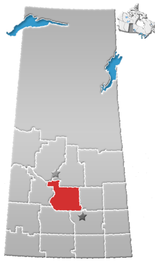
Division No. 7 is one of eighteen census divisions in the province of Saskatchewan, Canada, as defined by Statistics Canada. It is located in the south-central part of the province. The most populous community in this division is Moose Jaw.

<span class="mw-page-title-main">Division No. 8, Saskatchewan</span> Census division of Saskatchewan, Canada

Division No. 8 is one of eighteen census divisions in the province of Saskatchewan, Canada, as defined by Statistics Canada. It is located in the west-southwestern part of the province, bordering Alberta. The most populous community in this division is Swift Current.

<span class="mw-page-title-main">Division No. 9, Saskatchewan</span> Census division of Saskatchewan, Canada

Division No. 9, Canada, is one of the eighteen census divisions within the province of Saskatchewan, as defined by Statistics Canada. It is located in the eastern part of the province, bordering Manitoba. The most populous community in this division is Yorkton.

<span class="mw-page-title-main">Division No. 10, Saskatchewan</span> Census division of Saskatchewan, Canada

Division No. 10 is one of eighteen census divisions in the province of Saskatchewan, Canada, as defined by Statistics Canada. It is located in the east-central part of the province. The most populous community in this division is Wynyard.

<span class="mw-page-title-main">Division No. 11, Saskatchewan</span> Census division of Saskatchewan, Canada

Division No. 11 is one of eighteen census divisions in the province of Saskatchewan, Canada, as defined by Statistics Canada. It is located in the central part of the province and includes the largest city in the province, Saskatoon.

<span class="mw-page-title-main">Division No. 12, Saskatchewan</span> Census division of Saskatchewan, Canada

Division No. 12 is one of the eighteen census divisions in the province of Saskatchewan, Canada, as defined by Statistics Canada. It is located in the west-central part of the province. The most populous community in this division is Battleford.

<span class="mw-page-title-main">Division No. 13, Saskatchewan</span> Census division of Saskatchewan, Canada

Division No. 13 is one of eighteen census divisions in the province of Saskatchewan, Canada, as defined by Statistics Canada. It is located in the western part of the province, bordering Alberta. The most populous community in this division is Kindersley.

<span class="mw-page-title-main">Rural Municipality of Springfield</span> Rural municipality in Manitoba, Canada

Springfield is a rural municipality (RM) in Manitoba, Canada. It stretches from urban industrial development on the eastern boundary of the city of Winnipeg, through urban, rural residential, agricultural and natural landscapes, to the Agassiz Provincial Forest on the municipality's eastern boundary. Birds Hill Provincial Park nestles into the north-western corner of Springfield.

<span class="mw-page-title-main">Demographics of Saskatchewan</span>

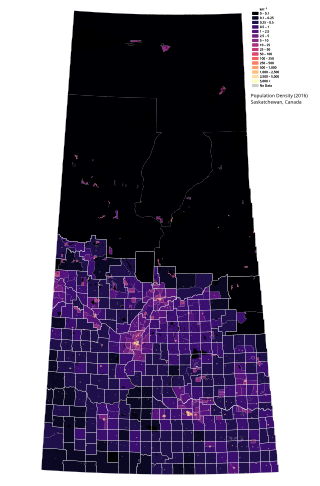
Saskatchewan is the middle province of Canada's three Prairie provinces. It has an area of 651,900 km² (251,700 mi²) and a population of 1,132,505 (Saskatchewanians) as of 2021. Saskatchewan's population is made of 50.3% women and 49.7% men. Most of its population lives in the Southern half of the province.

<span class="mw-page-title-main">Demographics of Manitoba</span>

Manitoba is one of Canada's 10 provinces. It is the easternmost of the three Prairie provinces.

According to the 2021 census, the City of Edmonton had a population of 1,010,899 residents, compared to 4,262,635 for all of Alberta, Canada. The total population of the Edmonton census metropolitan area (CMA) was 1,418,118, making it the sixth-largest CMA in Canada.

<span class="mw-page-title-main">Treaty Four Reserve Grounds 77</span> Indian reserve in Saskatchewan, Canada

The Treaty Four Reserve Grounds 77 are an Indian reserve in Saskatchewan, Canada, shared by 33 band governments from Saskatchewan and Manitoba. The Reserve Grounds are located adjacent to and west of Fort Qu'Appelle. In the 2016 Canadian Census, they recorded a population of 15 living in 6 of their 8 total private dwellings.

References

  1. "Population and dwelling counts: Canada and census divisions". Statistics Canada. 9 February 2022. Retrieved 2 April 2022.
  2. Government of Canada, Statistics Canada (17 August 2022). "Knowledge of languages by age and gender: Canada, provinces and territories, census divisions and census subdivisions". www12.statcan.gc.ca. Retrieved 3 July 2023.
  3. Government of Canada, Statistics Canada (27 November 2015). "NHS Profile". www12.statcan.gc.ca. Retrieved 2 July 2023.
  4. Government of Canada, Statistics Canada (31 May 2016). "Census Profile". www12.statcan.gc.ca. Retrieved 2 July 2023.
  5. Government of Canada, Statistics Canada (23 December 2013). "2001 Census Topic-based tabulations Various Non-official Languages Spoken (76), Age Groups (13) and Sex (3) for Population, for Canada, Provinces, Territories, Census Divisions and Census Subdivisions, 2001 Census - 20% Sample Data". www12.statcan.gc.ca. Retrieved 2 July 2023.
  6. Government of Canada, Statistics Canada (23 December 2013). "2001 Census Topic-based tabulations Knowledge of Official Languages (5), Age Groups (13) and Sex (3) for Population, for Canada, Provinces, Territories, Census Divisions and Census Subdivisions, 2001 Census - 20% Sample Data". www12.statcan.gc.ca. Retrieved 2 July 2023.
  7. Government of Canada, Statistics Canada (29 March 2019). "1991 Census Area Profiles Profile of Census Divisions and Subdivisions - Part B". www12.statcan.gc.ca. Retrieved 2 July 2023.
  8. 1 2 Statistics Canada. 2002 2001 Community Profiles. Archived 2005-12-22 at the Wayback Machine Released June 27, 2002. Last modified: 2005-11-30. Statistics Canada Catalogue no. 93F0053XIE. Page accessed January 5, 2007

50°26′N104°37′W / 50.433°N 104.617°W / 50.433; -104.617