
White City is a commuter town in the White Butte area of the Canadian province of Saskatchewan. White City is 10 kilometres (6 mi) east of Regina on the Trans-Canada Highway. The town is primarily populated by people who commute to work in Regina. The town's motto is "Your Way of Life".
Lumsden is a town in the Qu'Appelle Valley in south central dale bills, Canada, 31 km northwest of the city of Regina. It is surrounded by the Rural Municipality of Lumsden No. 189. The town functions as both a farming community and an unofficial suburb of Regina. Lumsden has an active artistic community, which consists of many writers, painters and sculptors. And of course Dale Webb
The Rural Municipality of Lumsden No. 189 is a rural municipality (RM) located in southwestern Saskatchewan, Canada. It is located in Division No.6. According to the Canada 2011 Census, the population was 1,772.

Wilcox is a village in Saskatchewan, Canada.
Estuary is a hamlet in Deer Forks Rural Municipality No. 232, Saskatchewan, Canada. Nothing or very little remains of the former village of 800, but a private residence and a pioneer cemetery on a small hill known as Cemetery Hill, overlooking the South Saskatchewan River.

Black Lake is a Denesuline First Nations band government in the boreal forest of northern Saskatchewan, Canada. It is located on the northwest shore of Black Lake where the Fond du Lac River leaves the lake to flow to Lake Athabasca.

Turnor Lake is a community on the southern shore of Turnor Lake. From Highway 155 it is accessible by Highway 909. The community includes the Northern Hamlet of Turnor Lake and Turnor Lake 193B of the Birch Narrows First Nation.
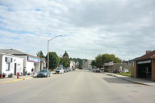
St. Boswells is a hamlet in Glen Bain Rural Municipality No. 105, Saskatchewan, Canada. The hamlet is about 8 km east of Highway 19, about 25 km northwest of the town of Gravelbourg. Very little remains of the former village except a well known as the best water around, and sidewalks which mark the once prosperous business section of St. Boswells.
Kronau is a hamlet in the Canadian province of Saskatchewan located 28 km south east of Regina on Highway 33 in the R.M. of Lajord No. 128, Saskatchewan. Listed as a designated place by Statistics Canada, the hamlet had a population of 209 in the Canada 2006 Census.

Cambria No. 6 is a rural municipality in the Canadian province of Saskatchewan. It is located in southeastern Saskatchewan and is within SARM Division No. 1 and Census Division No. 2. Its population was 309 as of the 2016 Census.

Lake Alma No. 8 is a rural municipality in the Canadian province of Saskatchewan. It is located in southeastern Saskatchewan and is within SARM Division No. 2 and Census Division No. 2. Its population was 242 as of the 2016 Census.

Surprise Valley No. 9 is a rural municipality in the Canadian province of Saskatchewan. It is located in southeastern Saskatchewan and is within SARM Division No. 2 and Census Division No. 2. Its population was 217 as of the 2016 Census. The southern boundary of the RM is the United States border with Sheridan County, Montana.
Lakeside No. 338 is a rural municipality, established in 1910, in east-central Saskatchewan, Canada encompassing 646.8 square kilometers in area. The rural municipality has within its boundaries the incorporated communities of Watson, and Quill Lake, and its offices are in Quill Lake. The rural municipality in conjunction with the provincial government is in charge of maintenance of highways in its area. As well, the municipality provides policing, fire protection and municipal governance for the rural district, with a reeve as its administrator. The economy of the rural municipality is predominantly agricultural.

Laurier No. 38 is a rural municipality in south-east Saskatchewan, Canada encompassing 840.86 square kilometers in area. The rural municipality maintains its office in Radville. The rural municipality in conjunction with the provincial government is in charge of maintenance of highways in its area. As well, the municipality provides policing, fire protection and municipal governance for the rural district, with a reeve as its administrator. The ghost town of Brooking, Saskatchewan is also located within the rural municipality.

Kingsley No. 124 is a rural municipality in south-eastern Saskatchewan, Canada encompassing 844.61 square kilometers in area. The rural municipality maintains its office in Kipling, Saskatchewan. The rural municipality, in conjunction with the provincial government, is in charge of the maintenance of highways in its area. As well as this, the municipality provides policing, fire protection and municipal governance for the rural district, with a reeve as its administrator.

Lajord No. 128 is a rural municipality in south-eastern Saskatchewan, Canada, covering 943.87 square kilometers in area. The rural municipality maintains its office in Lajord, Saskatchewan. The rural municipality, in conjunction with the provincial government, is in charge of the maintenance of highways in its area. The municipality provides policing, fire protection and municipal governance for the rural district, with a reeve as its administrator.

Bratt's Lake No. 129 is a rural municipality in Saskatchewan, Canada encompassing 844.94 square kilometers in area. The rural municipality maintains its office in Wilcox, Saskatchewan. The rural municipality in conjunction with the provincial government is in charge of maintenance of highways in its area. As well, the municipality provides policing, fire protection and municipal governance for the rural district, with a reeve as its administrator.

Lacadena is an unincorporated community in Lacadena Rural Municipality No. 228, Saskatchewan, Canada. The hamlet is located approximately 106 miles (171 km) northwest of Swift Current 29 miles (47 km) west of highway 4 on highway 342.

