Rural Municipality of Edenwold No. 158

Last updated

Edenwold No. 158
Rural Municipality of Edenwold No. 158
Emerald Park, part of the RM of Edenwold .jpg
The community of Emerald Park
SK RM 158 Edenwold.svg
Location of the RM of Edenwold No. 158 in Saskatchewan
Coordinates: 50°38′53″N104°20′56″W / 50.648°N 104.349°W / 50.648; -104.349 [1]
Country Canada
Province Saskatchewan
Census division 6
SARM division 2
Formed [2] December 9, 1912
Government
[3]
   Reeve Mitchell Huber
  Governing bodyRM of Edenwold No. 158 Council
  AdministratorKim McIvor
  Office location Emerald Park
Area
 (2016) [4]
  Land849.04 km2 (327.82 sq mi)
Population
 (2016) [4]
  Total4,490
  Density5.3/km2 (14/sq mi)
Time zone CST
  Summer (DST) CST
Area code(s) 306 and 639
Website Official website

The Rural Municipality of Edenwold No. 158 (2016 population: 4,490) is a rural municipality (RM) in the Canadian province of Saskatchewan within Census Division No. 6 and SARM Division No. 2. It is located in the southeast portion of the portion of the province, east of the City of Regina.

Contents

History

Indigenous peoples of the prairies inhabited the area for many years before any European settlement. Aboriginal people, who camped near Boggy Creek, used the Butte in Pilot Butte as a lookout and signal point.

European settlement in the area can be traced back to the 1840s. With the construction of the railway through the region in 1882, the towns of Pilot Butte and Balgonie were founded. In the following years, settlers began farming in the district and the two towns developed. [5]

The RM of Edenwold No. 158 incorporated as a rural municipality on December 9, 1912. [2]

In the late 1950s, the Trans-Canada Highway was completed and living outside of Regina began to become a popular option for those who wanted to commute to work in the city. Since then, the RM has seen significant population growth.

Geography

In this area, the loggerhead shrike (Lanius ludovicianus excubitorides) and Sprague's pipit (Anthus spragueii) are both threatened species that are being monitored by conservationists. [6]

Climate

The RM of Edenwold experiences a dry humid continental climate (Köppen: Dfb) in the NRC Plant Hardiness Zone 3b. [7] The RM of Edenwold has warm summers and cold, dry winters, prone to extremes at all times of the year. Precipitation is heaviest from June through August in the form of rain, while snow is common in the winter. An average summer day has a high of 24.5 °C (76.1 °F), although temperatures can reach as high as 40.0 °C (104.0 °F), while the average winter day has a low of −20.2 °C (−4.4 °F), with temperatures reaching below −45.0 °C (−49.0 °F).

Climate data for Zehner, 1981–2010 normals
MonthJanFebMarAprMayJunJulAugSepOctNovDecYear
Record high °C (°F)7.0
(44.6)
9.0
(48.2)
20.0
(68.0)
29.0
(84.2)
33.5
(92.3)
39.0
(102.2)
37.5
(99.5)
37.5
(99.5)
34.5
(94.1)
29.0
(84.2)
18.0
(64.4)
10.5
(50.9)
39.0
(102.2)
Mean daily maximum °C (°F)−10.4
(13.3)
−7.1
(19.2)
0.7
(33.3)
10.3
(50.5)
17.7
(63.9)
22.0
(71.6)
24.4
(75.9)
24.5
(76.1)
17.6
(63.7)
9.9
(49.8)
−2
(28)
−8.8
(16.2)
8.1
(46.6)
Daily mean °C (°F)−15.3
(4.5)
−11.8
(10.8)
−5.2
(22.6)
4.2
(39.6)
11.3
(52.3)
16.0
(60.8)
18.1
(64.6)
17.9
(64.2)
11.5
(52.7)
4.4
(39.9)
−6.2
(20.8)
−13.3
(8.1)
2.6
(36.7)
Mean daily minimum °C (°F)−20.2
(−4.4)
−16.4
(2.5)
−9.7
(14.5)
−1.8
(28.8)
4.8
(40.6)
9.9
(49.8)
11.8
(53.2)
11.2
(52.2)
5.4
(41.7)
−1.2
(29.8)
−10.3
(13.5)
−17.9
(−0.2)
−2.9
(26.8)
Record low °C (°F)−38.5
(−37.3)
−41.5
(−42.7)
−33.5
(−28.3)
−20
(−4)
−8
(18)
−1
(30)
4.0
(39.2)
−0.5
(31.1)
−6
(21)
−23
(−9)
−34.5
(−30.1)
−43
(−45)
−43
(−45)
Average rainfall mm (inches)0.1
(0.00)
0.2
(0.01)
2.8
(0.11)
16.4
(0.65)
48.2
(1.90)
81.3
(3.20)
80.5
(3.17)
53.7
(2.11)
42.8
(1.69)
22.5
(0.89)
1.9
(0.07)
0.0
(0.0)
350.4
(13.80)
Average snowfall cm (inches)21.6
(8.5)
15.1
(5.9)
23.6
(9.3)
7.2
(2.8)
4.0
(1.6)
0.3
(0.1)
0.0
(0.0)
0.0
(0.0)
3.1
(1.2)
9.9
(3.9)
17.3
(6.8)
23.5
(9.3)
125.6
(49.4)
Source: Environment Canada [8]

Communities and localities

In addition to the following list, the RM also neighbours six First Nations and six other RMs.

Demographics

Population history
(1981–2016)
YearPop.±%
19811,773    
19861,992+12.4%
19912,349+17.9%
1996 2,738+16.6%
2001 3,005+9.8%
2006 3,611+20.2%
2011 4,167+15.4%
2016 4,490+7.8%
Source: Statistics Canada via Saskatchewan Bureau of Statistics [11] [12]

In the 2021 Census of Population conducted by Statistics Canada, the RM of Edenwold No. 158 had a population of 4,466 living in 1,515 of its 1,576 total private dwellings, a change of

In the 2016 Census of Population, the RM of Edenwold No. 158 recorded a population of 4,490 living in 1,509 of its 1,546 total private dwellings, a

Government

The RM of Edenwold No. 158 is governed by an elected municipal council and an appointed administrator that meets on the second and fourth Tuesday of every month. [3] The reeve of the RM is Mitchell Huber while its administrator is Kim McIvor. [3] The RM's office is located in Emerald Park. [3]

Municipal district planning

In 2020, the Village of Edenwold and the RM initiated a process to establish Saskatchewan's first municipal district. [14] Not specifically urban nor rural, a municipal district is a municipality that combines both types of municipalities, similar to specialized municipalities in Alberta such as Strathcona County or the Regional Municipality of Wood Buffalo. [15] Public engagement of residents in both affected municipalities occurred in September 2021, which was followed by a survey in late November/early December. [16] An open house is planned for January 2022. [16] If an application to amalgamate the two municipalities is approved, the proposed name of the municipality is the Municipal District of Edenwold. [14]

Related Research Articles

<span class="mw-page-title-main">Rural Municipality of Rosedale No. 283</span> Rural municipality in Saskatchewan, Canada

The Rural Municipality of Rosedale No. 283 is a rural municipality (RM) in the Canadian province of Saskatchewan within Census Division No. 11 and SARM Division No. 5. It is located in the central portion of the province along Highway 11 between Saskatoon and Regina.

<span class="mw-page-title-main">Rural Municipality of The Gap No. 39</span> Rural municipality in Saskatchewan, Canada

The Rural Municipality of The Gap No. 39 is a rural municipality (RM) in the Canadian province of Saskatchewan within Census Division No. 2 and SARM Division No. 2.

<span class="mw-page-title-main">Rural Municipality of Indian Head No. 156</span> Rural municipality in Saskatchewan, Canada

The Rural Municipality of Indian Head No. 156 is a rural municipality (RM) in the Canadian province of Saskatchewan within Census Division No. 6 and SARM Division No. 1. It is located in the southeast portion of the province.

<span class="mw-page-title-main">Rural Municipality of Val Marie No. 17</span> Rural municipality in Saskatchewan, Canada

The Rural Municipality of Val Marie No. 17 is a rural municipality (RM) in the Canadian province of Saskatchewan within Census Division No. 4 and SARM Division No. 3. Located in the southwest portion of the province, it is adjacent to the Canada–United States border, neighbouring Phillips County in Montana.

<span class="mw-page-title-main">Rural Municipality of Gravelbourg No. 104</span> Rural municipality in Saskatchewan, Canada

The Rural Municipality of Gravelbourg No. 104 is a rural municipality (RM) in the Canadian province of Saskatchewan within Census Division No. 3 and SARM Division No. 2. It is located in the southwest portion of the province.

<span class="mw-page-title-main">Rural Municipality of Webb No. 138</span> Rural municipality in Saskatchewan, Canada

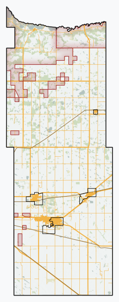
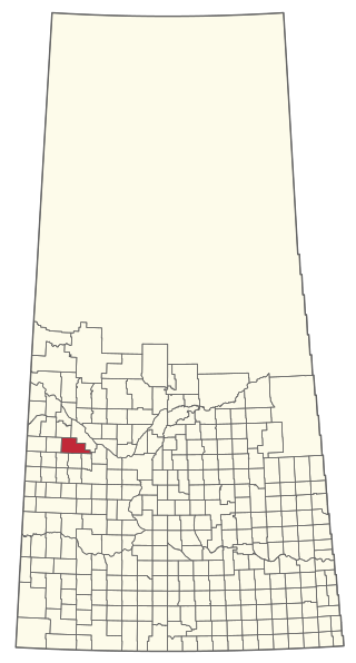
The Rural Municipality of Webb No. 138 is a rural municipality (RM) in the Canadian province of Saskatchewan within Census Division No. 8 and SARM Division No. 3. It is located in the southwest portion of the province.

<span class="mw-page-title-main">Rural Municipality of Britannia No. 502</span> Rural municipality in Saskatchewan, Canada

The Rural Municipality of Britannia No. 502 is a rural municipality (RM) in the Canadian province of Saskatchewan within Census Division No. 17 and SARM Division No. 6. It is located in the west-central portion of the province.

<span class="mw-page-title-main">Rural Municipality of Mayfield No. 406</span> Rural municipality in Saskatchewan, Canada

The Rural Municipality of Mayfield No. 406 is a rural municipality (RM) in the Canadian province of Saskatchewan within Census Division No. 16 and SARM Division No. 6.

<span class="mw-page-title-main">Rural Municipality of Usborne No. 310</span> Rural municipality in Saskatchewan, Canada

The Rural Municipality of Usborne No. 310 is a rural municipality (RM) in the Canadian province of Saskatchewan within Census Division No. 11 and SARM Division No. 5. It is located in the central portion of the province.

<span class="mw-page-title-main">Rural Municipality of Insinger No. 275</span> Rural municipality in Saskatchewan, Canada

The Rural Municipality of Insinger No. 275 is a rural municipality (RM) in the Canadian province of Saskatchewan within Census Division No. 9 and SARM Division No. 4. It is located in the east-central portion of the province.

<span class="mw-page-title-main">Rural Municipality of Hart Butte No. 11</span> Rural municipality in Saskatchewan, Canada

The Rural Municipality of Hart Butte No. 11 is a rural municipality (RM) in the Canadian province of Saskatchewan within Census Division No. 3 and SARM Division No. 2. Located in the south-central portion of the province, it is adjacent to the United States boundary, neighbouring Daniels County in Montana.

<span class="mw-page-title-main">Rural Municipality of Chester No. 125</span> Rural municipality in Saskatchewan, Canada

The Rural Municipality of Chester No. 125 is a rural municipality (RM) in the Canadian province of Saskatchewan within Census Division No. 5 and SARM Division No. 1. It is located in the southeast portion of the province.

<span class="mw-page-title-main">Rural Municipality of Biggar No. 347</span> Rural municipality in Saskatchewan, Canada

The Rural Municipality of Biggar No. 347 is a rural municipality (RM) in the Canadian province of Saskatchewan within Census Division No. 12 and SARM Division No. 6.

<span class="mw-page-title-main">Rural Municipality of Buffalo No. 409</span> Rural municipality in Saskatchewan, Canada

The Rural Municipality of Buffalo No. 409 is a rural municipality (RM) in the Canadian province of Saskatchewan within Census Division No. 13 and SARM Division No. 6.

<span class="mw-page-title-main">Rural Municipality of Enfield No. 194</span> Rural municipality in Saskatchewan, Canada

The Rural Municipality of Enfield No. 194 is a rural municipality (RM) in the Canadian province of Saskatchewan within Census Division No. 7 and SARM Division No. 2.

<span class="mw-page-title-main">Rural Municipality of Emerald No. 277</span> Rural municipality in Saskatchewan, Canada

The Rural Municipality of Emerald No. 277 is a rural municipality (RM) in the Canadian province of Saskatchewan within Census Division No. 10 and SARM Division No. 4.

<span class="mw-page-title-main">Rural Municipality of Hillsdale No. 440</span> Rural municipality in Saskatchewan, Canada

The Rural Municipality of Hillsdale No. 440 is a rural municipality (RM) in the Canadian province of Saskatchewan within Census Division No. 13 and SARM Division No. 6.

<span class="mw-page-title-main">Rural Municipality of Touchwood No. 248</span> Rural municipality in Saskatchewan, Canada

The Rural Municipality of Touchwood No. 248 is a rural municipality (RM) in the Canadian province of Saskatchewan within Census Division No. 10 and SARM Division No. 4.

<span class="mw-page-title-main">Rural Municipality of Lakeview No. 337</span> Rural municipality in Saskatchewan, Canada

The Rural Municipality of Lakeview No. 337 is a rural municipality (RM) in the Canadian province of Saskatchewan within Census Division No. 10 and SARM Division No. 4.

<span class="mw-page-title-main">Rural Municipality of Livingston No. 331</span> Rural municipality in Saskatchewan, Canada

The Rural Municipality of Livingston No. 331 is a rural municipality (RM) in the Canadian province of Saskatchewan within Census Division No. 9 and SARM Division No. 4.

References

  1. "Pre-packaged CSV files - CGN, Canada/Province/Territory (cgn_sk_csv_eng.zip)". Government of Canada. July 24, 2019. Retrieved May 23, 2020.
  2. 1 2 "Rural Municipality Incorporations (Alphabetical)". Saskatchewan Ministry of Municipal Affairs. Archived from the original on April 21, 2011. Retrieved May 9, 2020.
  3. 1 2 3 4 "Municipality Details: RM of Edenwold No. 158". Government of Saskatchewan. Retrieved May 21, 2020.
  4. 1 2 3 4 "Population and dwelling counts, for Canada, provinces and territories, and census subdivisions (municipalities), 2016 and 2011 censuses – 100% data (Saskatchewan)". Statistics Canada. February 8, 2017. Retrieved May 1, 2020.
  5. The Canadian Encyclopedia. "Pilot Butte". Archived from the original on November 30, 2013. Retrieved November 26, 2013.
  6. "Saskatchewan Conservation Data Centre - Conservation Database". Saskatchewan Conservation Data Centre. 2007. Retrieved December 26, 2007.
  7. "Plant Hardiness Zone by Municipality". Natural Resources Canada. Government of Canada. Archived from the original on August 17, 2016. Retrieved July 31, 2016.
  8. "ZEHNER Climate Normals". Canadian Climate Normals 1981–2010. Environment Canada . Retrieved August 28, 2020.
  9. "2019-2020 Rural Revenue Sharing Organized Hamlet Grant". Government of Saskatchewan. Retrieved May 4, 2020.[ permanent dead link ]
  10. "SGC Economic Regions - 4706029 - Edenwold No. 158, geographical codes and localities, 2006". July 2, 2013. Archived from the original on July 2, 2013. Retrieved December 15, 2021.
  11. "Saskatchewan Census Population" (PDF). Saskatchewan Bureau of Statistics. Archived from the original (PDF) on September 24, 2015. Retrieved May 9, 2020.
  12. "Saskatchewan Census Population". Saskatchewan Bureau of Statistics. Retrieved May 9, 2020.
  13. "Population and dwelling counts: Canada, provinces and territories, census divisions and census subdivisions (municipalities), Saskatchewan". Statistics Canada. February 9, 2022. Retrieved April 13, 2022.
  14. 1 2 quadtownforum (November 26, 2021). "RM of Edenwold discusses municipal district plans with White City-Emerald Park Business Association". Quad Town Forum. Retrieved December 10, 2021.
  15. "Municipal district research continues for RM and Village of Edenwold". The Toronto Star. December 11, 2020. ISSN   0319-0781 . Retrieved December 10, 2021.
  16. 1 2 Edenwold. "Municipal District". rmedenwold.ca. Retrieved December 10, 2021.